Polylines in .NET MAUI Maps (SfMaps)
15 Jul 202624 minutes to read
NOTE
Prerequisite: Ensure that the required NuGet package is installed, the necessary namespaces are imported, and the SfMaps control is properly configured in your application. For detailed setup and configuration instructions, refer to the Getting Started guide.
The polyline layer is a sublayer that renders a group of MapPolyline on MapShapeLayer. This section explains how to add and customize polylines.
Adding polylines
The Polylines is a collection of MapPolyline. Every single MapPolyline connects multiple coordinates through a Points property.
<map:SfMaps>
    <map:SfMaps.Layer>
        <map:MapShapeLayer ShapesSource="https://cdn.syncfusion.com/maps/map-data/india.json"
                           ShapeStroke="DarkGray">
            <map:MapShapeLayer.Sublayers>
                <map:MapPolylineLayer>
                    <map:MapPolylineLayer.Polylines>
                        <map:MapPolyline>
                            <map:MapPolyline.Points>
                                <map:MapLatLng Latitude="13.0827"
                                               Longitude="80.2707" />
                                <map:MapLatLng Latitude="13.1746"
                                               Longitude="79.6117" />
                                <map:MapLatLng Latitude="13.6373"
                                               Longitude="79.5037" />
                                <map:MapLatLng Latitude="14.4673"
                                               Longitude="78.8242" />
                                <map:MapLatLng Latitude="14.9091"
                                               Longitude="78.0092" />
                                <map:MapLatLng Latitude="16.2160"
                                               Longitude="77.3566" />
                                <map:MapLatLng Latitude="17.1557"
                                               Longitude="76.8697" />
                                <map:MapLatLng Latitude="18.0975"
                                               Longitude="75.4249" />
                                <map:MapLatLng Latitude="18.5204"
                                               Longitude="73.8567" />
                                <map:MapLatLng Latitude="19.0760"
                                               Longitude="72.8777" />
                            </map:MapPolyline.Points>
                        </map:MapPolyline>
                    </map:MapPolylineLayer.Polylines>
                </map:MapPolylineLayer>
            </map:MapShapeLayer.Sublayers>
        </map:MapShapeLayer>
    </map:SfMaps.Layer>
</map:SfMaps>
SfMaps maps = new SfMaps();
MapShapeLayer layer = new MapShapeLayer();
layer.ShapesSource = MapSource.FromUri(new Uri("https://cdn.syncfusion.com/maps/map-data/india.json"));
layer.ShapeStroke = Brush.DarkGray;
MapPolylineLayer mapPolylineLayer = new MapPolylineLayer();
MapPolyline polyline = new MapPolyline();
polyline.Points = new ObservableCollection<MapLatLng>()
{
new MapLatLng(13.0827, 80.2707),
new MapLatLng(13.1746, 79.6117),
new MapLatLng(13.6373, 79.5037),
new MapLatLng(14.4673, 78.8242),
new MapLatLng(14.9091, 78.0092),
new MapLatLng(16.2160, 77.3566),
new MapLatLng(17.1557, 76.8697),
new MapLatLng(18.0975, 75.4249),
new MapLatLng(18.5204, 73.8567),
new MapLatLng(19.0760, 72.8777),
};
mapPolylineLayer.Polylines.Add(polyline);
layer.Sublayers.Add(mapPolylineLayer);
maps.Layer = layer;
this.Content = maps;
Stroke
You can apply a color to each MapPolyline in the Polylines collection using the individual MapPolyline.Stroke property. When MapPolyline.Stroke is not set, the default stroke color is applied.
<map:SfMaps>
    <map:SfMaps.Layer>
        <map:MapShapeLayer ShapesSource="https://cdn.syncfusion.com/maps/map-data/india.json"
                           ShapeStroke="DarkGray">
            <map:MapShapeLayer.Sublayers>
                <map:MapPolylineLayer>
                    <map:MapPolylineLayer.Polylines>
                        <map:MapPolyline Stroke="#993fad">
                            <map:MapPolyline.Points>
                                <map:MapLatLng Latitude="13.0827"
                                               Longitude="80.2707" />
                                <map:MapLatLng Latitude="13.1746"
                                               Longitude="79.6117" />
                                <map:MapLatLng Latitude="13.6373"
                                               Longitude="79.5037" />
                                <map:MapLatLng Latitude="14.4673"
                                               Longitude="78.8242" />
                                <map:MapLatLng Latitude="14.9091"
                                               Longitude="78.0092" />
                                <map:MapLatLng Latitude="16.2160"
                                               Longitude="77.3566" />
                                <map:MapLatLng Latitude="17.1557"
                                               Longitude="76.8697" />
                                <map:MapLatLng Latitude="18.0975"
                                               Longitude="75.4249" />
                                <map:MapLatLng Latitude="18.5204"
                                               Longitude="73.8567" />
                                <map:MapLatLng Latitude="19.0760"
                                               Longitude="72.8777" />
                            </map:MapPolyline.Points>
                        </map:MapPolyline>
                    </map:MapPolylineLayer.Polylines>
                </map:MapPolylineLayer>
            </map:MapShapeLayer.Sublayers>
        </map:MapShapeLayer>
    </map:SfMaps.Layer>
</map:SfMaps>
SfMaps maps = new SfMaps();
MapShapeLayer layer = new MapShapeLayer();
layer.ShapesSource = MapSource.FromUri(new Uri("https://cdn.syncfusion.com/maps/map-data/india.json"));
layer.ShapeStroke = Brush.DarkGray;
MapPolylineLayer mapPolylineLayer = new MapPolylineLayer();
MapPolyline polyline = new MapPolyline();
polyline.Points = new ObservableCollection<MapLatLng>()
{
new MapLatLng(13.0827, 80.2707),
new MapLatLng(13.1746, 79.6117),
new MapLatLng(13.6373, 79.5037),
new MapLatLng(14.4673, 78.8242),
new MapLatLng(14.9091, 78.0092),
new MapLatLng(16.2160, 77.3566),
new MapLatLng(17.1557, 76.8697),
new MapLatLng(18.0975, 75.4249),
new MapLatLng(18.5204, 73.8567),
new MapLatLng(19.0760, 72.8777),
};
polyline.Stroke = Color.FromRgb(153, 63, 173);
mapPolylineLayer.Polylines.Add(polyline);
layer.Sublayers.Add(mapPolylineLayer);
maps.Layer = layer;
this.Content = maps;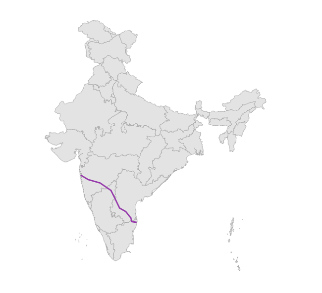
Stroke thickness
You can apply different stroke thickness values to each MapPolyline in the Polylines collection using the individual MapPolyline.StrokeThickness property. The default value of the MapPolyline.StrokeThickness property is 2, measured in device-independent units.
<map:SfMaps>
    <map:SfMaps.Layer>
        <map:MapShapeLayer ShapesSource="https://cdn.syncfusion.com/maps/map-data/india.json"
                           ShapeStroke="DarkGray">
            <map:MapShapeLayer.Sublayers>
                <map:MapPolylineLayer>
                    <map:MapPolylineLayer.Polylines>
                        <map:MapPolyline Stroke="DarkGray"
                                         StrokeThickness="3" >
                            <map:MapPolyline.Points>
                                <map:MapLatLng Latitude="13.0827"
                                               Longitude="80.2707" />
                                <map:MapLatLng Latitude="13.1746"
                                               Longitude="79.6117" />
                                <map:MapLatLng Latitude="13.6373"
                                               Longitude="79.5037" />
                                <map:MapLatLng Latitude="14.4673"
                                               Longitude="78.8242" />
                                <map:MapLatLng Latitude="14.9091"
                                               Longitude="78.0092" />
                                <map:MapLatLng Latitude="16.2160"
                                               Longitude="77.3566" />
                                <map:MapLatLng Latitude="17.1557"
                                               Longitude="76.8697" />
                                <map:MapLatLng Latitude="18.0975"
                                               Longitude="75.4249" />
                                <map:MapLatLng Latitude="18.5204"
                                               Longitude="73.8567" />
                                <map:MapLatLng Latitude="19.0760"
                                               Longitude="72.8777" />
                            </map:MapPolyline.Points>
                        </map:MapPolyline>
                    </map:MapPolylineLayer.Polylines>
                </map:MapPolylineLayer>
            </map:MapShapeLayer.Sublayers>
        </map:MapShapeLayer>
    </map:SfMaps.Layer>
</map:SfMaps>
SfMaps maps = new SfMaps();
MapShapeLayer layer = new MapShapeLayer();
layer.ShapesSource = MapSource.FromUri(new Uri("https://cdn.syncfusion.com/maps/map-data/india.json"));
layer.ShapeStroke = Brush.DarkGray;
MapPolylineLayer mapPolylineLayer = new MapPolylineLayer();
MapPolyline polyline = new MapPolyline();
polyline.Points = new ObservableCollection<MapLatLng>()
{
new MapLatLng(13.0827, 80.2707),
new MapLatLng(13.1746, 79.6117),
new MapLatLng(13.6373, 79.5037),
new MapLatLng(14.4673, 78.8242),
new MapLatLng(14.9091, 78.0092),
new MapLatLng(16.2160, 77.3566),
new MapLatLng(17.1557, 76.8697),
new MapLatLng(18.0975, 75.4249),
new MapLatLng(18.5204, 73.8567),
new MapLatLng(19.0760, 72.8777),
};
polyline.Stroke = Brush.DarkGray;
polyline.StrokeThickness = 3;
mapPolylineLayer.Polylines.Add(polyline);
layer.Sublayers.Add(mapPolylineLayer);
maps.Layer = layer;
this.Content = maps;
Stroke cap
You can apply different stroke cap styles to each MapPolyline in the Polylines collection using the individual MapPolyline.StrokeLineCap property. The default value of the MapPolyline.StrokeLineCap property is LineCap.Butt. The available values are Butt, Round, and Square, from the Microsoft.Maui.Graphics.LineCap enum. In XAML, the enum member name is set as a string (for example, StrokeLineCap="Round"), and in C#, the LineCap enum value is used (for example, polyline.StrokeLineCap = LineCap.Round;).
<map:SfMaps>
    <map:SfMaps.Layer>
        <map:MapShapeLayer ShapesSource="https://cdn.syncfusion.com/maps/map-data/india.json"
                           ShapeStroke="DarkGray">
            <map:MapShapeLayer.Sublayers>
                <map:MapPolylineLayer>
                    <map:MapPolylineLayer.Polylines>
                        <map:MapPolyline Stroke="DarkGray"
                                         StrokeThickness="5"
                                         StrokeLineCap="Round">
                            <map:MapPolyline.Points>
                                <map:MapLatLng Latitude="13.0827"
                                               Longitude="80.2707" />
                                <map:MapLatLng Latitude="13.1746"
                                               Longitude="79.6117" />
                                <map:MapLatLng Latitude="13.6373"
                                               Longitude="79.5037" />
                                <map:MapLatLng Latitude="14.4673"
                                               Longitude="78.8242" />
                                <map:MapLatLng Latitude="14.9091"
                                               Longitude="78.0092" />
                                <map:MapLatLng Latitude="16.2160"
                                               Longitude="77.3566" />
                                <map:MapLatLng Latitude="17.1557"
                                               Longitude="76.8697" />
                                <map:MapLatLng Latitude="18.0975"
                                               Longitude="75.4249" />
                                <map:MapLatLng Latitude="18.5204"
                                               Longitude="73.8567" />
                                <map:MapLatLng Latitude="19.0760"
                                               Longitude="72.8777" />
                            </map:MapPolyline.Points>
                        </map:MapPolyline>
                    </map:MapPolylineLayer.Polylines>
                </map:MapPolylineLayer>
            </map:MapShapeLayer.Sublayers>
        </map:MapShapeLayer>
    </map:SfMaps.Layer>
</map:SfMaps>
SfMaps maps = new SfMaps();
MapShapeLayer layer = new MapShapeLayer();
layer.ShapesSource = MapSource.FromUri(new Uri("https://cdn.syncfusion.com/maps/map-data/india.json"));
layer.ShapeStroke = Brush.DarkGray;
MapPolylineLayer mapPolylineLayer = new MapPolylineLayer();
MapPolyline polyline = new MapPolyline();
polyline.Points = new ObservableCollection<MapLatLng>()
{
new MapLatLng(13.0827, 80.2707),
new MapLatLng(13.1746, 79.6117),
new MapLatLng(13.6373, 79.5037),
new MapLatLng(14.4673, 78.8242),
new MapLatLng(14.9091, 78.0092),
new MapLatLng(16.2160, 77.3566),
new MapLatLng(17.1557, 76.8697),
new MapLatLng(18.0975, 75.4249),
new MapLatLng(18.5204, 73.8567),
new MapLatLng(19.0760, 72.8777),
};
polyline.Stroke = Brush.DarkGray;
polyline.StrokeThickness = 5;
polyline.StrokeLineCap = LineCap.Round;
mapPolylineLayer.Polylines.Add(polyline);
layer.Sublayers.Add(mapPolylineLayer);
maps.Layer = layer;
this.Content = maps;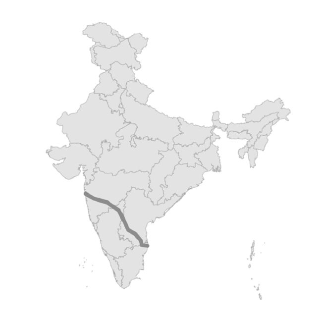
Dash array
You can apply dash support for the polyline using the MapPolyline.StrokeDashArray property.
A sequence of dashes and gaps is rendered based on the values in this list. Once all the values in the list are rendered, the sequence repeats until the end of the polyline. When MapPolyline.StrokeDashArray is not set, a solid line is rendered. The values are specified in device-independent units that match the StrokeThickness coordinate space.
<map:SfMaps>
    <map:SfMaps.Layer>
        <map:MapShapeLayer ShapesSource="https://cdn.syncfusion.com/maps/map-data/india.json"
                           ShapeStroke="DarkGray">
            <map:MapShapeLayer.Sublayers>
                <map:MapPolylineLayer>
                    <map:MapPolylineLayer.Polylines>
                        <map:MapPolyline Stroke="#52a8ef">
                            <map:MapPolyline.Points>
                                <map:MapLatLng Latitude="13.0827"
                                               Longitude="80.2707" />
                                <map:MapLatLng Latitude="13.1746"
                                               Longitude="79.6117" />
                                <map:MapLatLng Latitude="13.6373"
                                               Longitude="79.5037" />
                                <map:MapLatLng Latitude="14.4673"
                                               Longitude="78.8242" />
                                <map:MapLatLng Latitude="14.9091"
                                               Longitude="78.0092" />
                                <map:MapLatLng Latitude="16.2160"
                                               Longitude="77.3566" />
                                <map:MapLatLng Latitude="17.1557"
                                               Longitude="76.8697" />
                                <map:MapLatLng Latitude="18.0975"
                                               Longitude="75.4249" />
                                <map:MapLatLng Latitude="18.5204"
                                               Longitude="73.8567" />
                                <map:MapLatLng Latitude="19.0760"
                                               Longitude="72.8777" />
                            </map:MapPolyline.Points>
                            <map:MapPolyline.StrokeDashArray>
                                <DoubleCollection>
                                    <x:Double>4</x:Double>
                                    <x:Double>2</x:Double>
                                    <x:Double>1</x:Double>
                                    <x:Double>2</x:Double>
                                </DoubleCollection>
                            </map:MapPolyline.StrokeDashArray>
                        </map:MapPolyline>
                    </map:MapPolylineLayer.Polylines>
                </map:MapPolylineLayer>
            </map:MapShapeLayer.Sublayers>
        </map:MapShapeLayer>
    </map:SfMaps.Layer>
</map:SfMaps>
SfMaps maps = new SfMaps();
MapShapeLayer layer = new MapShapeLayer();
layer.ShapesSource = MapSource.FromUri(new Uri("https://cdn.syncfusion.com/maps/map-data/india.json"));
layer.ShapeStroke = Brush.DarkGray;
MapPolylineLayer mapPolylineLayer = new MapPolylineLayer();
MapPolyline polyline = new MapPolyline();
polyline.Points = new ObservableCollection<MapLatLng>()
{
new MapLatLng(13.0827, 80.2707),
new MapLatLng(13.1746, 79.6117),
new MapLatLng(13.6373, 79.5037),
new MapLatLng(14.4673, 78.8242),
new MapLatLng(14.9091, 78.0092),
new MapLatLng(16.2160, 77.3566),
new MapLatLng(17.1557, 76.8697),
new MapLatLng(18.0975, 75.4249),
new MapLatLng(18.5204, 73.8567),
new MapLatLng(19.0760, 72.8777),
};
polyline.Stroke = Color.FromRgb(82, 168, 239);
polyline.StrokeDashArray = new double[] { 4, 2, 1, 2 };
mapPolylineLayer.Polylines.Add(polyline);
layer.Sublayers.Add(mapPolylineLayer);
maps.Layer = layer;
this.Content = maps;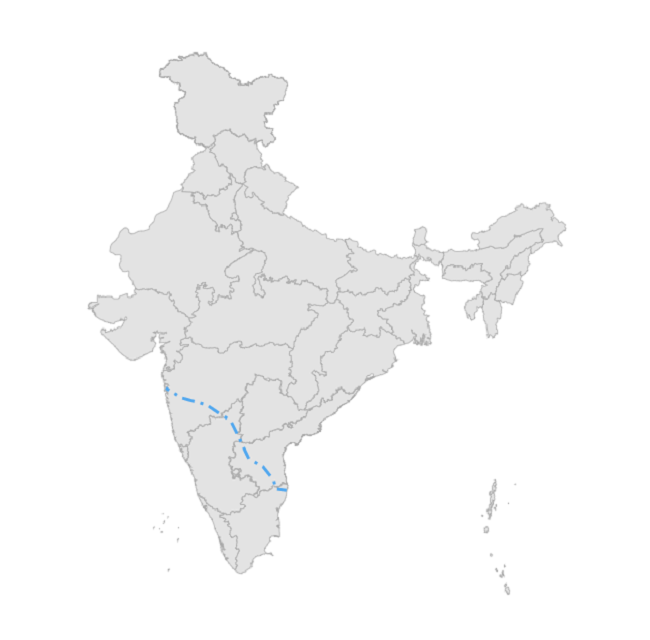
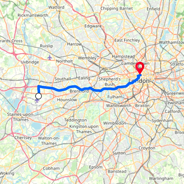
Animation
You can apply animation for the MapPolyline using the MapPolylineLayer.AnimationDuration and MapPolylineLayer.AnimationEasing properties. MapPolylineLayer.AnimationDuration is specified in milliseconds. The available AnimationEasing values are the members of the Microsoft.Maui.Easing enum (for example, Easing.SinInOut, Easing.CubicInOut, Easing.Linear).
By default, animation is disabled.
<map:SfMaps>
    <map:SfMaps.Layer>
        <map:MapTileLayer UrlTemplate="https://tile.openstreetmap.org/{z}/{x}/{y}.png">
            <map:MapTileLayer.Center>
                <map:MapLatLng>
                    <x:Arguments>
                        <x:Double>51.4700</x:Double>
                        <x:Double>-0.2843</x:Double>
                    </x:Arguments>
                </map:MapLatLng>
            </map:MapTileLayer.Center>
            <map:MapTileLayer.ZoomPanBehavior>
                <map:MapZoomPanBehavior ZoomLevel="10"
                                        MinZoomLevel="9"
                                        MaxZoomLevel="12" />
            </map:MapTileLayer.ZoomPanBehavior>
            <map:MapTileLayer.Sublayers>
                <map:MapPolylineLayer AnimationDuration="3000"
                                      AnimationEasing="{x:Static Easing.SinInOut}">
                    <map:MapPolylineLayer.Polylines>
                        <map:MapPolyline x:Name="polyline"
                                         Stroke="#0066FF"
                                         StrokeThickness="6" />
                    </map:MapPolylineLayer.Polylines>
                </map:MapPolylineLayer>
            </map:MapTileLayer.Sublayers>
        </map:MapTileLayer>
    </map:SfMaps.Layer>
</map:SfMaps>
SfMaps maps = new SfMaps();
MapTileLayer tileLayer = new MapTileLayer();
tileLayer.UrlTemplate = "https://tile.openstreetmap.org/{z}/{x}/{y}.png";
tileLayer.Center = new MapLatLng(51.4700, -0.2843);
tileLayer.ZoomPanBehavior = new MapZoomPanBehavior()
{
ZoomLevel = 10,
MinZoomLevel = 9,
MaxZoomLevel = 12,
};
MapPolylineLayer polylineLayer = new MapPolylineLayer();
polylineLayer.AnimationDuration = 3000;
polylineLayer.AnimationEasing = Easing.SinInOut;
MapPolyline polyline = new MapPolyline();
polyline.Stroke = Color.FromRgb(0, 102, 255);
polyline.StrokeThickness = 6;
// Assign the polyline points from your data source (for example, a JSON/GeoJSON file or an in-memory collection).
polyline.Points = new ObservableCollection<MapLatLng>()
{
// code omitted for brevity
};
polylineLayer.Polylines.Add(polyline);
tileLayer.Sublayers.Add(polylineLayer);
maps.Layer = tileLayer;
this.Content = maps;