Markers in .NET MAUI Maps
20 Jul 202624 minutes to read
Markers can be used to denote locations. It is possible to use the built-in symbols or display a custom control at a specific latitude and longitude on a map.
NOTE
Prerequisite: Ensure that the required NuGet package is installed, the necessary namespaces are imported, and the SfMaps control is properly configured in your application. For detailed setup and configuration instructions, refer to the Getting Started guide.
To learn more about the .NET MAUI Maps markers, you can check the following video.
Adding markers
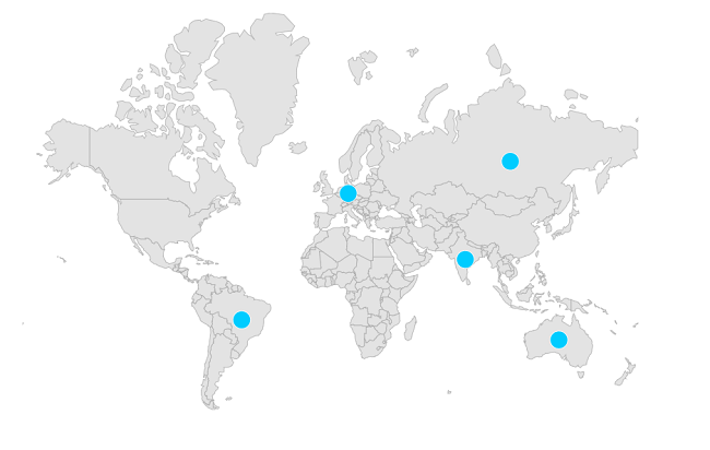
Shape layer
You can show markers at any position on the map by providing latitude and longitude position to the MapMarker, which is from the Markers collection.
<map:SfMaps>
    <map:SfMaps.Layer>
        <map:MapShapeLayer ShapesSource = "https://cdn.syncfusion.com/maps/map-data/world-map.json"
                           ShapeStroke = "DarkGrey">

            <map:MapShapeLayer.Markers>
                <map:MapMarkerCollection>
                    <map:MapMarker Latitude = "-14.235004"
                                   IconWidth = "15"
                                   IconHeight = "15"
                                   IconFill = "#00ccff"
                                   IconType = "Circle"
                                   Longitude = "-51.92528" />
                    <map:MapMarker Latitude = "51.16569"
                                   IconWidth = "15"
                                   IconHeight = "15"
                                   IconFill = "#00ccff"
                                   IconType = "Circle"
                                   Longitude = "10.451526" />
                    <map:MapMarker Latitude = "-25.274398"
                                   IconWidth = "15"
                                   IconHeight = "15"
                                   IconFill = "#00ccff"
                                   IconType = "Circle"
                                   Longitude = "133.775136" />
                    <map:MapMarker Latitude = "20.593684"
                                   IconWidth = "15"
                                   IconHeight = "15"
                                   IconFill = "#00ccff"
                                   IconType = "Circle"
                                   Longitude = "78.96288" />
                    <map:MapMarker Latitude = "61.52401"
                                   IconWidth = "15"
                                   IconHeight = "15"
                                   IconType = "Circle"
                                   IconFill = "#00ccff"
                                   Longitude = "105.318756" />
                </map:MapMarkerCollection>
            </map:MapShapeLayer.Markers>
        </map:MapShapeLayer>
    </map:SfMaps.Layer>
</map:SfMaps>
public MarkerTool()
{
InitializeComponent();
MapShapeLayer layer = new MapShapeLayer();
layer.ShapesSource = MapSource.FromUri(new Uri("https://cdn.syncfusion.com/maps/map-data/world-map.json"));
MapMarker mapMarker = new MapMarker();
mapMarker.Latitude = -14.235004;
mapMarker.Longitude = -51.92528;
mapMarker.IconHeight = 15;
mapMarker.IconWidth = 15;
mapMarker.IconType = MapIconType.Circle;
mapMarker.IconFill = new SolidColorBrush(Color.FromRgb(0, 204, 255));
MapMarker mapMarker1 = new MapMarker();
mapMarker1.Latitude = 51.16569;
mapMarker1.Longitude = 10.451526;
mapMarker1.IconHeight = 20;
mapMarker1.IconWidth = 20;
mapMarker1.IconType = MapIconType.Circle;
mapMarker1.IconFill = new SolidColorBrush(Color.FromRgb(0, 204, 255));
MapMarker mapMarker2 = new MapMarker();
mapMarker2.Latitude = -25.274398;
mapMarker2.Longitude = 133.775136;
mapMarker2.IconHeight = 15;
mapMarker2.IconWidth = 15;
mapMarker2.IconType = MapIconType.Circle;
mapMarker2.IconFill = new SolidColorBrush(Color.FromRgb(0, 204, 255));
MapMarker mapMarker3 = new MapMarker();
mapMarker3.Latitude = 20.593684;
mapMarker3.Longitude = 78.96288;
mapMarker3.IconHeight = 15;
mapMarker3.IconWidth = 15;
mapMarker3.IconType = MapIconType.Circle;
mapMarker3.IconFill = new SolidColorBrush(Color.FromRgb(0, 204, 255));
MapMarker mapMarker4 = new MapMarker();
mapMarker4.Latitude = 61.52401;
mapMarker4.Longitude = 105.318756;
mapMarker4.IconHeight = 15;
mapMarker4.IconWidth = 15;
mapMarker4.IconType = MapIconType.Circle;
mapMarker4.IconFill = new SolidColorBrush(Color.FromRgb(0, 204, 255));
MapMarkerCollection mapMarkers = new MapMarkerCollection();
mapMarkers.Add(mapMarker);
mapMarkers.Add(mapMarker1);
mapMarkers.Add(mapMarker2);
mapMarkers.Add(mapMarker3);
mapMarkers.Add(mapMarker4);
layer.Markers = mapMarkers;
SfMaps map = new SfMaps();
map.Layer = layer;
map.Margin = new Thickness(0, 50, 0, 0);
this.Content = map;
}
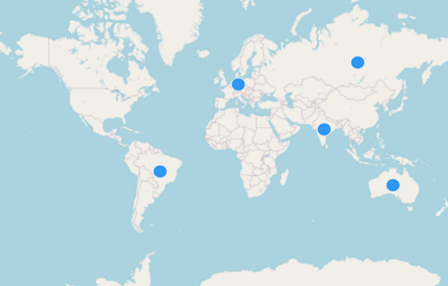
Tile layer
You can show markers at any position on the map by providing latitude and longitude position to the MapMarker, which is from the Markers collection.
<map:SfMaps>
    <map:SfMaps.Layer>
        <map:MapTileLayer UrlTemplate = "https://tile.openstreetmap.org/{z}/{x}/{y}.png" >
           <map:MapTileLayer.Markers>
                <map:MapMarkerCollection>
                        <map:MapMarker Latitude = "-14.235004"
                                       IconWidth = "15"
                                       IconHeight = "15"
                                       IconFill = "#2f98f3"
                                       IconType = "Circle"
                                       Longitude = "-51.92528" />
                        <map:MapMarker Latitude = "51.16569"
                                       IconWidth = "15"
                                       IconHeight = "15"
                                       IconFill = "#2f98f3"
                                       IconType = "Circle"
                                       Longitude = "10.451526" />
                        <map:MapMarker Latitude = "-25.274398"
                                       IconWidth = "15"
                                       IconHeight = "15"
                                       IconFill = "#2f98f3"
                                       IconType = "Circle"
                                       Longitude = "133.775136" />
                        <map:MapMarker Latitude = "20.593684"
                                       IconWidth = "15"
                                       IconHeight = "15"
                                       IconFill = "#2f98f3"
                                       IconType = "Circle"
                                       Longitude = "78.96288" />
                        <map:MapMarker Latitude = "61.52401"
                                       IconWidth = "15"
                                       IconHeight = "15"
                                       IconType = "Circle"
                                       IconFill = "#2f98f3"
                                       Longitude = "105.318756" />
                    </map:MapMarkerCollection>
            </map:MapTileLayer.Markers>
        </map:MapTileLayer>
    </map:SfMaps.Layer>
</map:SfMaps>
public MarkerTool()
{
InitializeComponent();
SfMaps map = new SfMaps();
MapTileLayer tileLayer = new MapTileLayer();
tileLayer.UrlTemplate = "https://tile.openstreetmap.org/{z}/{x}/{y}.png";
MapMarker mapMarker = new MapMarker();
mapMarker.Latitude = -14.235004;
mapMarker.Longitude = -51.92528;
mapMarker.IconHeight = 15;
mapMarker.IconWidth = 15;
mapMarker.IconType = MapIconType.Circle;
mapMarker.IconFill = new SolidColorBrush(Color.FromRgb(47, 152, 243));
MapMarker mapMarker1 = new MapMarker();
mapMarker1.Latitude = 51.16569;
mapMarker1.Longitude = 10.451526;
mapMarker1.IconHeight = 20;
mapMarker1.IconWidth = 20;
mapMarker1.IconType = MapIconType.Circle;
mapMarker1.IconFill = new SolidColorBrush(Color.FromRgb(47, 152, 243));
MapMarker mapMarker2 = new MapMarker();
mapMarker2.Latitude = -25.274398;
mapMarker2.Longitude = 133.775136;
mapMarker2.IconHeight = 15;
mapMarker2.IconWidth = 15;
mapMarker2.IconType = MapIconType.Circle;
mapMarker2.IconFill = new SolidColorBrush(Color.FromRgb(47, 152, 243));
MapMarker mapMarker3 = new MapMarker();
mapMarker3.Latitude = 20.593684;
mapMarker3.Longitude = 78.96288;
mapMarker3.IconHeight = 15;
mapMarker3.IconWidth = 15;
mapMarker3.IconType = MapIconType.Circle;
mapMarker3.IconFill = new SolidColorBrush(Color.FromRgb(47, 152, 243));
MapMarker mapMarker4 = new MapMarker();
mapMarker4.Latitude = 61.52401;
mapMarker4.Longitude = 105.318756;
mapMarker4.IconHeight = 15;
mapMarker4.IconWidth = 15;
mapMarker4.IconType = MapIconType.Circle;
mapMarker4.IconFill = new SolidColorBrush(Color.FromRgb(47, 152, 243));
MapMarkerCollection mapMarkers = new MapMarkerCollection();
mapMarkers.Add(mapMarker);
mapMarkers.Add(mapMarker1);
mapMarkers.Add(mapMarker2);
mapMarkers.Add(mapMarker3);
mapMarkers.Add(mapMarker4);
tileLayer.Markers = mapMarkers;
map.Layer = tileLayer;
map.Margin = new Thickness(0, 50, 0, 0);
this.Content = map;
}
NOTE
- Refer to the
MapMarkerCollection, for collection ofMapMarker.
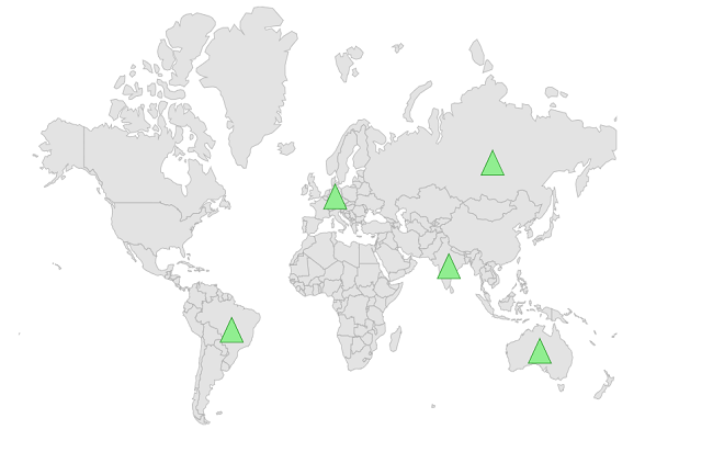
Appearance customization
You can customize the built-in markers appearance using the IconType, IconFill, IconStroke, IconStrokeThickness, IconWidth, and IconHeight properties of the MapMarker.
-
Alignment - You can change the position of the marker from the given coordinate using the
HorizontalAlignmentandVerticalAlignmentproperties. The default value isMapAlignment.Center. The available alignment options areCenter,Start, andEnd. -
Offset - You can adjust the marker position from the given coordinate using the
Offsetproperty. The default value of theOffsetproperty isPoint.Zero.
NOTE
- The default value of the
IconTypeisMapIconType.Circle.- The default value of the
IconStrokeThicknessis1.0.- The default value of the
IconFillisColor.FromRgb(138, 69, 175).- The default value of the
IconWidthandIconHeightis8.0.
<map:SfMaps>
    <map:SfMaps.Layer>
        <map:MapShapeLayer ShapesSource = "https://cdn.syncfusion.com/maps/map-data/world-map.json"
                           ShapeStroke = "DarkGrey">
            <map:MapShapeLayer.Markers>
                <map:MapMarkerCollection>
                    <map:MapMarker Latitude = "-14.235004"
                                   IconWidth = "20"
                                   IconHeight = "20"
                                   IconFill = "LightGreen"
                                   IconType = "Triangle"
                                   Longitude = "-51.92528" />
                    <map:MapMarker Latitude = "51.16569"
                                   IconWidth = "20"
                                   IconHeight = "20"
                                   IconFill = "LightGreen"
                                   IconStroke = "Green"
                                   IconType = "Triangle"
                                   Longitude = "10.451526" />
                    <map:MapMarker Latitude = "-25.274398"
                                   IconWidth = "20"
                                   IconHeight = "20"
                                   IconFill = "LightGreen"
                                   IconStroke = "Green"
                                   IconType = "Triangle"
                                   Longitude = "133.775136" />
                    <map:MapMarker Latitude = "20.593684"
                                   IconWidth = "20"
                                   IconHeight = "20"
                                   IconFill = "LightGreen"
                                   IconStroke = "Green"
                                   IconType = "Triangle"
                                   Longitude = "78.96288" />
                    <map:MapMarker Latitude = "61.52401"
                                   IconWidth = "20"
                                   IconHeight = "20"
                                   IconType = "Triangle"
                                   IconFill = "LightGreen"
                                   IconStroke = "Green"
                                   Longitude = "105.318756" />
                </map:MapMarkerCollection>
            </map:MapShapeLayer.Markers>
        </map:MapShapeLayer>
    </map:SfMaps.Layer>
</map:SfMaps>
public MarkerTool()
{
InitializeComponent();
MapShapeLayer layer = new MapShapeLayer();
layer.ShapesSource = MapSource.FromUri(new Uri("https://cdn.syncfusion.com/maps/map-data/world-map.json"));
MapMarker mapMarker = new MapMarker();
mapMarker.Latitude = -14.235004;
mapMarker.Longitude = -51.92528;
mapMarker.IconHeight = 20;
mapMarker.IconWidth = 20;
mapMarker.IconType = MapIconType.Triangle;
mapMarker.IconFill = new SolidColorBrush(Colors.LightGreen);
mapMarker.IconStroke = new SolidColorBrush(Colors.Green);
mapMarker.IconStrokeThickness = 3;
MapMarker mapMarker1 = new MapMarker();
mapMarker1.Latitude = 51.16569;
mapMarker1.Longitude = 10.451526;
mapMarker1.IconHeight = 20;
mapMarker1.IconWidth = 20;
mapMarker1.IconType = MapIconType.Triangle;
mapMarker1.IconFill = new SolidColorBrush(Colors.LightGreen);
mapMarker1.IconStroke = new SolidColorBrush(Colors.Green);
mapMarker1.IconStrokeThickness = 3;
MapMarker mapMarker2 = new MapMarker();
mapMarker2.Latitude = -25.274398;
mapMarker2.Longitude = 133.775136;
mapMarker2.IconHeight = 20;
mapMarker2.IconWidth = 20;
mapMarker2.IconType = MapIconType.Triangle;
mapMarker2.IconFill = new SolidColorBrush(Colors.LightGreen);
mapMarker2.IconStroke = new SolidColorBrush(Colors.Green);
mapMarker2.IconStrokeThickness = 3;
MapMarker mapMarker3 = new MapMarker();
mapMarker3.Latitude = 20.593684;
mapMarker3.Longitude = 78.96288;
mapMarker3.IconHeight = 20;
mapMarker3.IconWidth = 20;
mapMarker3.IconType = MapIconType.Triangle;
mapMarker3.IconFill = new SolidColorBrush(Colors.LightGreen);
mapMarker3.IconStroke = new SolidColorBrush(Colors.Green);
mapMarker3.IconStrokeThickness = 3;
MapMarker mapMarker4 = new MapMarker();
mapMarker4.Latitude = 61.52401;
mapMarker4.Longitude = 105.318756;
mapMarker4.IconHeight = 20;
mapMarker4.IconWidth = 20;
mapMarker4.IconType = MapIconType.Triangle;
mapMarker4.IconFill = new SolidColorBrush(Colors.LightGreen);
mapMarker4.IconStroke = new SolidColorBrush(Colors.Green);
mapMarker4.IconStrokeThickness = 3;
MapMarkerCollection mapMarkers = new MapMarkerCollection();
mapMarkers.Add(mapMarker);
mapMarkers.Add(mapMarker1);
mapMarkers.Add(mapMarker2);
mapMarkers.Add(mapMarker3);
mapMarkers.Add(mapMarker4);
layer.Markers = mapMarkers;
SfMaps map = new SfMaps();
map.Layer = layer;
map.Margin = new Thickness(0, 50, 0, 0);
this.Content = map;
}
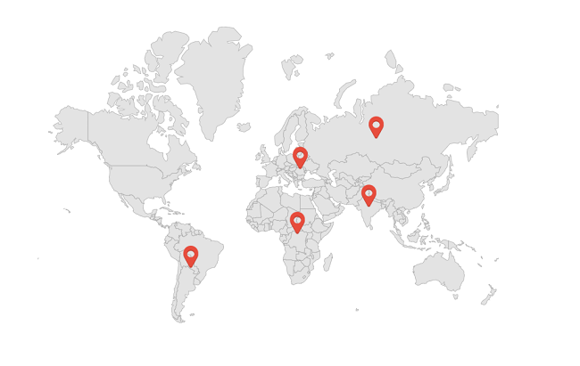
Adding custom markers
You can show custom markers using the MarkerTemplate property of the MapShapeLayer which returns the template to customize markers.
NOTE
The
map.pngimage used in the marker template must be added to your project (for example, in theResources/Images/folder) and referenced asSource = "map.png".
<ContentPage.Resources>
    <ResourceDictionary>
        <DataTemplate x:Key = "LowPopulationTemplate">
            <VerticalStackLayout HorizontalOptions = "StartAndExpand"
                         VerticalOptions = "Center">
                <Image Source = "map.png"
                       HeightRequest = "30"
                       WidthRequest = "30" />
            </VerticalStackLayout>
        </DataTemplate>
    </ResourceDictionary>
</ContentPage.Resources>

<map:SfMaps>
    <map:SfMaps.Layer>
        <map:MapShapeLayer ShapesSource = "https://cdn.syncfusion.com/maps/map-data/world-map.json"
                           ShapeStroke = "DarkGrey"
                           MarkerTemplate = "{StaticResource LowPopulationTemplate}"
                           ShowMarkerTooltip = "True">

            <map:MapShapeLayer.Markers>
                <map:MapMarkerCollection>
                    <map:MapMarker Latitude = "20.5595"
                                   Longitude = "22.9375"
                                   HorizontalAlignment = "Center"
                                   VerticalAlignment = "Start" />
                    <map:MapMarker Latitude = "21.7679"
                                   Longitude = "78.8718"
                                   HorizontalAlignment = "Center"
                                   VerticalAlignment = "Start" />
                    <map:MapMarker Latitude = "-25.2744"
                                   Longitude = "133.7751"
                                   HorizontalAlignment = "Center"
                                   VerticalAlignment = "Start" />
                    <map:MapMarker Latitude = "60.2551"
                                   Longitude = "84.5260"
                                   HorizontalAlignment = "Center"
                                   VerticalAlignment = "Start" />
                    <map:MapMarker Latitude = "-15.4915"
                                   Longitude = "-50.7832"
                                   HorizontalAlignment = "Center"
                                   VerticalAlignment = "Start" />
                </map:MapMarkerCollection>
            </map:MapShapeLayer.Markers>
        </map:MapShapeLayer>
    </map:SfMaps.Layer>
</map:SfMaps>
public MainPage()
{
InitializeComponent();
MapShapeLayer layer = new MapShapeLayer();
layer.ShapesSource = MapSource.FromUri(new Uri("https://cdn.syncfusion.com/maps/map-data/world-map.json"));
MapMarker mapMarker = new MapMarker();
mapMarker.Latitude = 20.5595;
mapMarker.Longitude = 22.9375;
MapMarker mapMarker1 = new MapMarker();
mapMarker1.Latitude = 21.7679;
mapMarker1.Longitude = 78.8718;
MapMarker mapMarker2 = new MapMarker();
mapMarker2.Latitude = -25.2744;
mapMarker2.Longitude = 133.7751;
MapMarker mapMarker3 = new MapMarker();
mapMarker3.Latitude = 60.2551;
mapMarker3.Longitude = 84.5260;
MapMarker mapMarker4 = new MapMarker();
mapMarker4.Latitude = -15.4915;
mapMarker4.Longitude = -50.7832;
MapMarkerCollection mapMarkers = new MapMarkerCollection();
mapMarkers.Add(mapMarker);
mapMarkers.Add(mapMarker1);
mapMarkers.Add(mapMarker2);
mapMarkers.Add(mapMarker3);
mapMarkers.Add(mapMarker4);
layer.Markers = mapMarkers;
layer.MarkerTemplate = CreateDataTemplate();
SfMaps map = new SfMaps();
map.Layer = layer;
map.Margin = new Thickness(0, 50, 0, 0);
this.Content = map;
}
private DataTemplate CreateDataTemplate()
{
return new DataTemplate(() =>
{
var stackLayout = new VerticalStackLayout();
var image = new Image
{
Source = "map.png",
WidthRequest = 20,
HeightRequest = 20
};
stackLayout.Add(image);
return stackLayout;
});
}
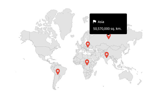
Customizing data templates in marker tooltip
A data template can be used to customize the marker tooltip using the MarkerTooltipTemplate property. The following code example shows the usage of DataTemplate.
<ContentPage.Resources>
    <ResourceDictionary>
        <DataTemplate x:Key = "MapMarkerTemplate">
            <VerticalStackLayout HorizontalOptions = "StartAndExpand"
                         VerticalOptions = "Center">
                <Image Source = "map.png"
                       HeightRequest = "30"
                       WidthRequest = "30" />
            </VerticalStackLayout>
        </DataTemplate>
    </ResourceDictionary>
</ContentPage.Resources>

<map:SfMaps>
    <map:SfMaps.Layer>
        <map:MapShapeLayer ShapesSource = "https://cdn.syncfusion.com/maps/map-data/world-map.json"
                           ShapeStroke = "DarkGrey"
                           ShapeHoverFill = "Transparent"
                           ShapeHoverStroke = "Transparent"
                           MarkerTemplate = "{StaticResource MapMarkerTemplate}"
                           ShowMarkerTooltip = "True">

            <map:MapShapeLayer.Markers>
                <map:MapMarkerCollection>
                    <local:CustomMarker Name = "South africa"
                                        Area = "38,570,000 sq. km."
                                        Latitude = "20.5595"
                                        Longitude = "22.9375" />
                    <local:CustomMarker Name = "India"
                                        Area = "30,370,000 sq. km."
                                        Latitude = "21.7679"
                                        Longitude = "78.8718" />
                    <local:CustomMarker Name = "Europe"
                                        Area = "20,370,000 sq. km."
                                        Latitude = "-25.2744"
                                        Longitude = "133.7751" />
                    <local:CustomMarker Name = "Asia"
                                        Area = "50,570,000 sq. km."
                                        Latitude = "60.2551"
                                        Longitude = "84.5260" />
                    <local:CustomMarker Name = "South America"
                                        Area = "30,370,000 sq. km."
                                        Latitude = "-15.4915"
                                        Longitude = "-50.7832" />
                </map:MapMarkerCollection>
            </map:MapShapeLayer.Markers>

            <map:MapShapeLayer.MarkerTooltipTemplate>
                <DataTemplate>
                    <Grid Padding = "10"
                          WidthRequest = "150">
                        <Grid.RowDefinitions>
                            <RowDefinition Height = "Auto" />
                            <RowDefinition Height = "Auto" />
                            <RowDefinition Height = "Auto" />
                        </Grid.RowDefinitions>
                        <Grid.ColumnDefinitions>
                            <ColumnDefinition Width = "10" />
                            <ColumnDefinition Width = "Auto" />
                        </Grid.ColumnDefinitions>
                        <Image Source = "flag.png"
                               Grid.Column = "0"
                               Grid.Row = "0"
                               WidthRequest = "20"
                               HeightRequest = "20" />
                        <Label Text = "{Binding Name}"
                               TextColor = "White"
                               Grid.Column = "1"
                               Grid.Row = "0"
                               Padding = "10" />
                        <Label Grid.Row = "2"
                               Grid.ColumnSpan = "2"
                               Text = "{Binding Area}"
                               TextColor = "White" />
                    </Grid>
                </DataTemplate>
            </map:MapShapeLayer.MarkerTooltipTemplate>

        </map:MapShapeLayer>
    </map:SfMaps.Layer>
</map:SfMaps>
public MainPage()
{
InitializeComponent();
MapShapeLayer layer = new MapShapeLayer();
layer.ShapesSource = MapSource.FromUri(new Uri("https://cdn.syncfusion.com/maps/map-data/world-map.json"));
layer.ShapeHoverFill = Colors.Transparent;
layer.ShapeHoverStroke = Colors.Transparent;
CustomMarker customMarker = new CustomMarker();
customMarker.Latitude = 20.5595;
customMarker.Longitude = 22.9375;
customMarker.Name = "South africa";
customMarker.Area = "38,570,000 sq. km.";
CustomMarker customMarker1 = new CustomMarker();
customMarker1.Latitude = 21.7679;
customMarker1.Longitude = 78.8718;
customMarker1.Name = "India";
customMarker1.Area = "30,370,000 sq. km.";
CustomMarker customMarker2 = new CustomMarker();
customMarker2.Latitude = -25.2744;
customMarker2.Longitude = 133.7751;
customMarker2.Name = "Europe";
customMarker2.Area = "20,370,000 sq. km.";
CustomMarker customMarker3 = new CustomMarker();
customMarker3.Latitude = 60.2551;
customMarker3.Longitude = 84.5260;
customMarker3.Name = "Asia";
customMarker3.Area = "50,570,000 sq. km.";
CustomMarker customMarker4 = new CustomMarker();
customMarker4.Latitude = -15.4915;
customMarker4.Longitude = -50.7832;
customMarker4.Name = "South America";
customMarker4.Area = "30,370,000 sq. km.";
MapMarkerCollection mapMarkers = new MapMarkerCollection();
mapMarkers.Add(customMarker);
mapMarkers.Add(customMarker1);
mapMarkers.Add(customMarker2);
mapMarkers.Add(customMarker3);
mapMarkers.Add(customMarker4);
layer.Markers = mapMarkers;
layer.MarkerTemplate = CreateDataTemplate();
layer.MarkerTooltipTemplate = CreateToolTip();
layer.ShowMarkerTooltip = true;
SfMaps map = new SfMaps();
map.Layer = layer;
map.Margin = new Thickness(0, 50, 0, 0);
this.Content = map;
}
private DataTemplate CreateDataTemplate()
{
return new DataTemplate(() =>
{
var stackLayout = new VerticalStackLayout();
var image = new Image
{
Source = "map.png",
WidthRequest = 20,
HeightRequest = 20
};
stackLayout.Add(image);
return stackLayout;
});
}
private DataTemplate CreateToolTip()
{
return new DataTemplate(() =>
{
var grid = new Grid()
{
RowDefinitions =
{
new RowDefinition(),
new RowDefinition(),
new RowDefinition()
},
ColumnDefinitions =
{
new ColumnDefinition(),
new ColumnDefinition(),
}
};
var image = new Image
{
Source = "flag.png",
WidthRequest = 20,
HeightRequest = 20
};
grid.SetRow(image, 0);
grid.SetColumn(image, 0);
var label = new Label
{
FontAttributes = FontAttributes.Bold,
TextColor = Colors.White,
Padding = 5,
Text = "Asia"
};
Binding binding = new Binding();
binding.Path = nameof(CustomMarker.Name);
label.SetBinding(Label.TextProperty, binding);
grid.SetRow(label, 0);
grid.SetColumn(label, 1);
var areaLabel = new Label
{
FontAttributes = FontAttributes.Bold,
Text = "10,180,000 sq. km.",
TextColor = Colors.White
};
Binding binding1 = new Binding();
binding1.Path = nameof(CustomMarker.Area);
areaLabel.SetBinding(Label.TextProperty, binding1);
grid.SetRow(areaLabel, 2); grid.SetColumnSpan(areaLabel, 2);
grid.Children.Add(image);
grid.Children.Add(label);
grid.Children.Add(areaLabel);
return new ViewCell { View = grid };
});
}
public class CustomMarker : MapMarker
{
public string Name { get; set; }
public string Area { get; set; }
}
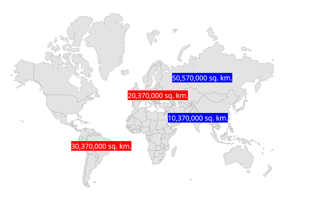
Customizing data templates selector in markers
A data template selector can also be used to customize the appearance of each item with different templates based on specific constraints. You can choose a DataTemplate for each item at runtime based on the value of the data-bound property using DataTemplateSelector in the MarkerTooltipTemplate property.
<ContentPage.Resources>
        <ResourceDictionary>
            <DataTemplate x:Key = "MarkerTemplate1">
                <VerticalStackLayout IsClippedToBounds = "false"
                         HorizontalOptions = "StartAndExpand"
                         VerticalOptions = "Center"
                         HeightRequest = "30">
                    <Label Text = "{Binding Latitude}"
                           Scale = "1"
                           TextColor = "White"
                           BackgroundColor = "Blue"
                           HorizontalOptions = "StartAndExpand"
                           VerticalOptions = "Center" />
                </VerticalStackLayout>
            </DataTemplate>

            <DataTemplate x:Key = "MarkerTemplate2">
                <VerticalStackLayout IsClippedToBounds = "false"
                         HorizontalOptions = "StartAndExpand"
                         VerticalOptions = "Center"
                         HeightRequest = "30">
                    <Label Text = "{Binding Latitude}"
                           Scale = "1"
                           TextColor = "White"
                           BackgroundColor = "Red"
                           HorizontalOptions = "StartAndExpand"
                           VerticalOptions = "Center" />
                </VerticalStackLayout>
            </DataTemplate>

			<local:MarkerTemplateSelector x:Key = "MarkerTemplateSelector"
										  Template1 = "{StaticResource MarkerTemplate1}"
										  Template2 = "{StaticResource MarkerTemplate2}" />

        </ResourceDictionary>
    </ContentPage.Resources>

	<map:SfMaps>
        <map:SfMaps.Layer>
            <map:MapShapeLayer ShapesSource = "https://cdn.syncfusion.com/maps/map-data/world-map.json"
                               ShapeStroke = "DarkGrey"
                               MarkerTemplate = "{StaticResource MarkerTemplateSelector}">

                <map:MapShapeLayer.Markers>
                    <map:MapMarkerCollection>
                        <local:CustomMarker1 Latitude = "21.7679"
                                             Longitude = "78.8718"
                                             Area = "10,370,000 sq. km."
                                             Population = "15" />
                        <local:CustomMarker1 Latitude = "-25.2744"
                                             Longitude = "133.7751"
                                             Area = "20,370,000 sq. km."
                                             Population = "31" />
                        <local:CustomMarker1 Latitude = "60.2551"
                                             Longitude = "84.5260"
                                             Area = "50,570,000 sq. km."
                                             Population = "26" />
                        <local:CustomMarker1 Latitude = "-15.4915"
                                             Longitude = "-50.7832"
                                             Area = "30,370,000 sq. km."
                                             Population = "40" />
                    </map:MapMarkerCollection>
                </map:MapShapeLayer.Markers>

            </map:MapShapeLayer>
        </map:SfMaps.Layer>
    </map:SfMaps>
public class MarkerTemplateSelector : DataTemplateSelector
{
public DataTemplate Template1 { get; set; }
public DataTemplate Template2 { get; set; }
protected override DataTemplate OnSelectTemplate(object item, BindableObject container)
{
return (double)((CustomMarker1)item).Population < 30 ? Template1 : Template2;
}
}
public class CustomMarker1 : MapMarker
{
public string Area { get; set; }
public double Population { get; set; }
}
Marker selection
The .NET MAUI Maps control allows users to interact with markers. When a marker is selected, developers can handle the interaction using command-based binding, enabling seamless integration with MVVM architecture.
Marker selected command
The MarkerSelectedCommand property allows you to bind a command that is executed when a marker is selected. This eliminates the need for event handlers in code-behind and promotes clean architecture practices.
You can also pass a custom parameter using the MarkerSelectedCommandParameter property. If no parameter is specified, the selected marker instance is passed to the command by default.
<map:SfMaps>
     <map:SfMaps.Layer>
         <map:MapShapeLayer ShapesSource = "https://cdn.syncfusion.com/maps/map-data/world-map.json"
                            MarkerSelectedCommand = "{Binding MarkerSelectedCommand}"
                            MarkerSelectedCommandParameter = "{Binding SelectionContext}"
                            ShapeStroke = "DarkGrey">

             <map:MapShapeLayer.Markers>
                 <map:MapMarkerCollection>
                     <!-- code omitted for brevity -->
                 </map:MapMarkerCollection>
             </map:MapShapeLayer.Markers>
         </map:MapShapeLayer>
     </map:SfMaps.Layer>
 </map:SfMaps>
public class MapViewModel
{
// Command for marker selection
public ICommand MarkerSelectedCommand { get; }
// Custom parameter (bound from XAML)
public string SelectionContext { get; set; }
public MapViewModel()
{
// Initialize parameter
SelectionContext = "Default Context";
// Initialize command
MarkerSelectedCommand = new Command<object>(OnMarkerSelected);
}
private void OnMarkerSelected(object parameter)
{
// code omitted for brevity
}
}NOTE
You can refer to our .NET MAUI Maps feature tour page for its groundbreaking feature representations. You can also explore our .NET MAUI Maps Markers example that shows how to configure a Maps in .NET MAUI.