Data Labels in .NET MAUI Maps (SfMaps)
15 Jul 202611 minutes to read
NOTE
Prerequisite: Ensure that the required NuGet package is installed, the necessary namespaces are imported, and the Maps control is properly configured in your application. For detailed setup and configuration instructions, refer to the Getting Started guide.
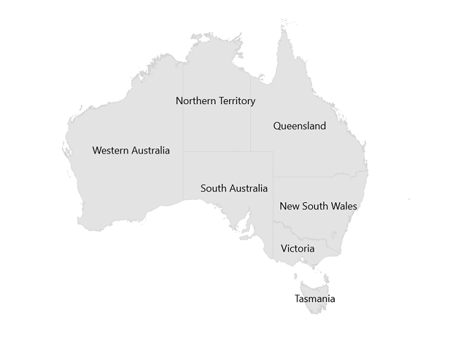
Data labels provide identification for the shapes by displaying their names. You can trim or hide the labels if they exceed the shape bounds.
To learn more about the .NET MAUI Maps data labels, you can check the following video.
Show data labels
You can show data labels on the map using the ShowDataLabels and DataLabelPath properties. The ShowDataLabels property is used to control the visibility of data labels, and the DataLabelPath property is used to decide which underlying property has to be displayed as data labels. The default value of ShowDataLabels is false.
IMPORTANT
Line breaks in the data label string (using
\n) are supported and will render as multiline labels within the shape.
<map:SfMaps>
    <map:SfMaps.Layer>
        <map:MapShapeLayer ShapesSource="https://cdn.syncfusion.com/maps/map-data/australia.json"
                           DataSource="{Binding Data}"
                           PrimaryValuePath="State"
                           ShapeDataField="STATE_NAME"
                           ShowDataLabels="True">

            <map:MapShapeLayer.DataLabelSettings>
                <map:MapDataLabelSettings DataLabelPath="DisplayName" />
            </map:MapShapeLayer.DataLabelSettings>
        </map:MapShapeLayer>
    </map:SfMaps.Layer>
</map:SfMaps>
public MainPage()
{
InitializeComponent();
ViewModel viewModel = new ViewModel();
this.BindingContext = viewModel;
MapShapeLayer layer = new MapShapeLayer();
layer.ShapesSource = MapSource.FromUri(new Uri("https://cdn.syncfusion.com/maps/map-data/australia.json"));
layer.DataSource = viewModel.Data;
layer.PrimaryValuePath = "State";
layer.ShapeDataField = "STATE_NAME";
layer.ShowDataLabels = true;
layer.DataLabelSettings = new MapDataLabelSettings()
{
DataLabelPath = "DisplayName",
};
SfMaps maps = new SfMaps();
maps.Layer = layer;
this.Content = maps;
}
public class ViewModel
{
public ObservableCollection<Model> Data { get; set; }
public ViewModel()
{
Data = new ObservableCollection<Model>();
Data.Add(new Model("New South Wales", "New\nSouth Wales"));
Data.Add(new Model("Queensland", "Queensland"));
Data.Add(new Model("Northern Territory", "Northern\nTerritory"));
Data.Add(new Model("Victoria", "Victoria"));
Data.Add(new Model("Tasmania", "Tasmania"));
Data.Add(new Model("Western Australia", "Western Australia"));
Data.Add(new Model("South Australia", "South Australia"));
}
}
public class Model
{
public string State { get; set; }
public string DisplayName { get; set; }
public Model(string state, string displayName)
{
State = state;
DisplayName = displayName;
}
}
Overflow mode of data labels
You can trim or hide the data labels when a data label overflows the shape bounds, using the OverflowMode property. The possible values are None, Trim, and Hide. The default value of the OverflowMode property is MapLabelOverflowMode.None.
- None - The data labels will render even if they overflow the shape bounds.
- Trim - The data labels are truncated with an ellipsis when they exceed the shape bounds.
- Hide - The data labels that exceed the shape bounds are not rendered.
<map:SfMaps>
    <map:SfMaps.Layer>
        <map:MapShapeLayer ShapesSource="https://cdn.syncfusion.com/maps/map-data/australia.json"
                           DataSource="{Binding Data}"
                           PrimaryValuePath="State"
                           ShapeDataField="STATE_NAME"
                           ShowDataLabels="True">

            <map:MapShapeLayer.DataLabelSettings>
                <map:MapDataLabelSettings OverflowMode="Trim"
                                          DataLabelPath="DisplayName" />
            </map:MapShapeLayer.DataLabelSettings>
        </map:MapShapeLayer>
    </map:SfMaps.Layer>
</map:SfMaps>
public MainPage()
{
InitializeComponent();
ViewModel viewModel = new ViewModel();
this.BindingContext = viewModel;
MapShapeLayer layer = new MapShapeLayer();
layer.ShapesSource = MapSource.FromUri(new Uri("https://cdn.syncfusion.com/maps/map-data/australia.json"));
layer.DataSource = viewModel.Data;
layer.PrimaryValuePath = "State";
layer.ShapeDataField = "STATE_NAME";
layer.ShowDataLabels = true;
layer.DataLabelSettings = new MapDataLabelSettings()
{
DataLabelPath = "DisplayName",
OverflowMode = MapLabelOverflowMode.Trim,
};
SfMaps maps = new SfMaps();
maps.Layer = layer;
this.Content = maps;
}
//code omitted for brevity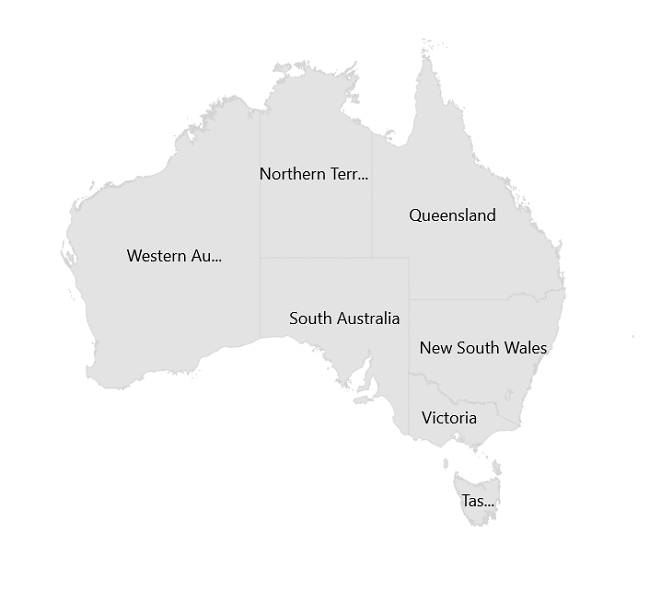
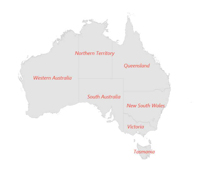
Appearance customization of data labels
You can customize the data labels using the DataLabelStyle property. The following MapLabelStyle properties are available to customize the data label appearance: FontSize, FontAttributes, FontFamily, TextColor, Margin, and Padding.
<map:SfMaps>
    <map:SfMaps.Layer>
        <map:MapShapeLayer ShapesSource="https://cdn.syncfusion.com/maps/map-data/australia.json"
                           DataSource="{Binding Data}"
                           PrimaryValuePath="State"
                           ShapeDataField="STATE_NAME"
                           ShowDataLabels="True">

            <map:MapShapeLayer.DataLabelSettings>
                <map:MapDataLabelSettings OverflowMode="Trim"
                                          DataLabelPath="DisplayName">
                        <map:MapDataLabelSettings.DataLabelStyle>
                                <map:MapLabelStyle FontSize="12"
                                                   TextColor="#ff4e41"
                                                   FontAttributes="Italic" />
                        </map:MapDataLabelSettings.DataLabelStyle>
                </map:MapDataLabelSettings>
            </map:MapShapeLayer.DataLabelSettings>

        </map:MapShapeLayer>
    </map:SfMaps.Layer>
</map:SfMaps>
public MainPage()
{
InitializeComponent();
ViewModel viewModel = new ViewModel();
this.BindingContext = viewModel;
MapShapeLayer layer = new MapShapeLayer();
layer.ShapesSource = MapSource.FromUri(new Uri("https://cdn.syncfusion.com/maps/map-data/australia.json"));
layer.DataSource = viewModel.Data;
layer.PrimaryValuePath = "State";
layer.ShapeDataField = "STATE_NAME";
layer.ShowDataLabels = true;
layer.DataLabelSettings = new MapDataLabelSettings()
{
DataLabelPath = "DisplayName",
OverflowMode = MapLabelOverflowMode.Trim,
DataLabelStyle = new MapLabelStyle()
{
FontSize = 12,
FontAttributes = FontAttributes.Italic,
TextColor = Color.FromRgb(255, 78, 65)
},
};
SfMaps maps = new SfMaps();
maps.Layer = layer;
this.Content = maps;
}
//code omitted for brevity