Flutter Maps Markers (SfMaps)
16 Apr 202624 minutes to read
Markers can be used to denote specific locations on a map. You can use built-in symbols or display custom widgets at specific latitude and longitude coordinates on the map.
Adding markers
Shape layer
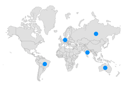
You can show markers at any position on the map by providing latitude and longitude coordinates to the MapMarker, which is returned from the markerBuilder property.
The markerBuilder callback will be called a number of times equal to the value specified in the initialMarkersCount property. The default value of the initialMarkersCount property is null.
late List<Model> _data;
late MapShapeSource _dataSource;

@override
void initState() {
  _data = const <Model>[
    Model('Brazil', -14.235004, -51.92528),
    Model('Germany', 51.16569, 10.451526),
    Model('Australia', -25.274398, 133.775136),
    Model('India', 20.593684, 78.96288),
    Model('Russia', 61.52401, 105.318756)
  ];

  _dataSource = MapShapeSource.asset(
    'assets/world_map.json',
    shapeDataField: 'name',
    dataCount: _data.length,
    primaryValueMapper: (index) => _data[index].country,
  );
  super.initState();
}

@override
Widget build(BuildContext context) {
  return Scaffold(
    body: Center(
        child: Padding(
      padding: EdgeInsets.only(left: 15, right: 15),
      child: SfMaps(
        layers: <MapLayer>[
          MapShapeLayer(
            source: _dataSource,
            initialMarkersCount: 5,
            markerBuilder: (BuildContext context, int index) {
              return MapMarker(
                latitude: _data[index].latitude,
                longitude: _data[index].longitude,
                iconColor: Colors.blue,
              );
            },
          ),
        ],
      ),
    )),
  );
}

class Model {
  const Model(this.country, this.latitude, this.longitude);

  final String country;
  final double latitude;
  final double longitude;
}
NOTE
- Refer to the
markerBuilderdocumentation for returning theMapMarker.- Refer to the
controllerdocumentation for dynamically updating the markers.
Tile layer
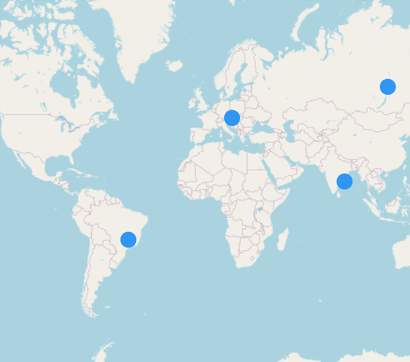
You can show markers at any position on the map by providing latitude and longitude coordinates to the MapMarker, which is returned from the MapTileLayer.markerBuilder property.
The markerBuilder callback will be called a number of times equal to the value specified in the initialMarkersCount property. The default value of the initialMarkersCount property is null.
late List<Model> _data;

@override
void initState() {
  _data = const <Model>[
    Model('Brazil', -14.235004, -51.92528),
    Model('Germany', 51.16569, 10.451526),
    Model('Australia', -25.274398, 133.775136),
    Model('India', 20.593684, 78.96288),
    Model('Russia', 61.52401, 105.318756)
  ];

  super.initState();
}

@override
Widget build(BuildContext context) {
  return Scaffold(
    body: Center(
      child: SfMaps(
        layers: <MapLayer>[
          MapTileLayer(
            urlTemplate: 'https://tile.openstreetmap.org/{z}/{x}/{y}.png',
            initialMarkersCount: 5,
            markerBuilder: (BuildContext context, int index) {
              return MapMarker(
                latitude: _data[index].latitude,
                longitude: _data[index].longitude,
                iconColor: Colors.blue,
              );
            },
          ),
        ],
      ),
    ),
  );
}

class Model {
  const Model(this.country, this.latitude, this.longitude);

  final String country;
  final double latitude;
  final double longitude;
}
NOTE
- Refer to the
markerBuilderdocumentation for returning theMapMarker.- Refer to the
controllerdocumentation for dynamically updating the markers.
Appearance customization
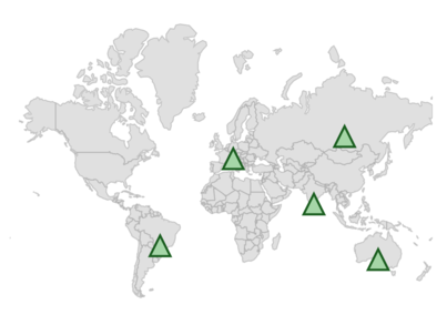
You can customize the built-in markers appearance using the iconType, iconColor, iconStrokeColor, iconStrokeWidth, and size properties of the MapMarker.
-
Alignment - You can change the position of the marker from the given coordinate using the
alignmentproperty. The default value isAlignment.center. The available alignment options aretopLeft,topRight,topCenter,centerLeft,center,centerRight,bottomLeft,bottomCenter,bottomRight. -
Offset - You can adjust the marker position from the given coordinate using the
offsetproperty. The default value of theoffsetproperty isOffset.zero.
NOTE
- The default value of the
iconTypeisMapIconType.circle.- The default value of the
iconStrokeWidthis1.0.- The default value of the
iconColorisColors.blue.- The default value of the
sizeisSize(14.0, 14.0).
late List<Model> _data;
late MapShapeSource _dataSource;

@override
void initState() {
  _data = <Model>[
    Model(-14.235004, -51.92528),
    Model(51.16569, 10.451526),
    Model(-25.274398, 133.775136),
    Model(20.593684, 78.96288),
    Model(61.52401, 105.318756)
  ];

  _dataSource = MapShapeSource.asset(
    'assets/world_map.json',
    shapeDataField: 'name',
  );
  super.initState();
}

@override
Widget build(BuildContext context) {
  return Scaffold(
    body: Center(
        child: Padding(
      padding: EdgeInsets.only(left: 15, right: 15),
      child: SfMaps(
        layers: <MapLayer>[
          MapShapeLayer(
            source: _dataSource,
            initialMarkersCount: 5,
            markerBuilder: (BuildContext context, int index) {
              return MapMarker(
                latitude: _data[index].latitude,
                longitude: _data[index].longitude,
                iconType: MapIconType.triangle,
                size: Size(18, 18),
                alignment: Alignment.center,
                offset: Offset(0, 9),
                iconColor: Colors.green[200],
                iconStrokeColor: Colors.green[900],
                iconStrokeWidth: 2,
              );
            },
          ),
        ],
      ),
    )),
  );
}

class Model {
  Model(this.latitude, this.longitude);

  final double latitude;
  final double longitude;
}
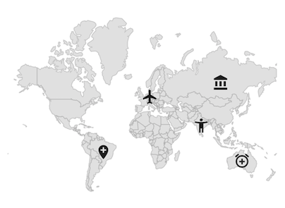
Adding custom markers
You can show custom markers using the child property of the MapMarker which is returned from the markerBuilder.
late List<Model> _data;
late List<Widget> _iconsList;
late MapShapeSource _dataSource;

@override
void initState() {
  _data = <Model>[
    Model(-14.235004, -51.92528),
    Model(51.16569, 10.451526),
    Model(-25.274398, 133.775136),
    Model(20.593684, 78.96288),
    Model(61.52401, 105.318756)
  ];

  _iconsList = <Widget>[
    Icon(Icons.add_location),
    Icon(Icons.airplanemode_active),
    Icon(Icons.add_alarm),
    Icon(Icons.accessibility_new),
    Icon(Icons.account_balance)
  ];

  _dataSource = MapShapeSource.asset(
    'assets/world_map.json',
    shapeDataField: 'name',
  );
  super.initState();
}

@override
Widget build(BuildContext context) {
  return Scaffold(
    body: Center(
        child: Padding(
      padding: EdgeInsets.only(left: 15, right: 15),
      child: SfMaps(
        layers: <MapLayer>[
          MapShapeLayer(
            source: _dataSource,
            initialMarkersCount: 5,
            markerBuilder: (BuildContext context, int index) {
              return MapMarker(
                latitude: _data[index].latitude,
                longitude: _data[index].longitude,
                child: _iconsList[index],
              );
            },
          ),
        ],
      ),
    )),
  );
}

class Model {
  Model(this.latitude, this.longitude);

  final double latitude;
  final double longitude;
}
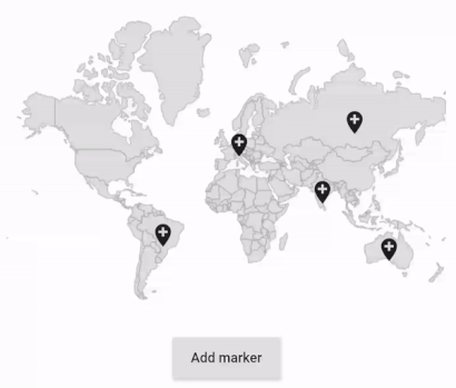
Adding markers dynamically
You can add markers dynamically using the insertMarker method. The markerBuilder will be called for the respective index once the insertMarker method is called. The controller property of MapShapeLayer must be set with a new instance of MapShapeLayerController.
A marker will be inserted at the given index if the index value is less than or equal to the current available index. The marker will be added as the last item if the index value is greater than the current available index.
NOTE
You can get the current markers count from
MapShapeLayerController.markersCount.
For shape layer
late List<Model> _data;
late MapShapeLayerController _controller;
late MapShapeSource _dataSource;
late Random random;

@override
void initState() {
  _data = <Model>[
    Model(-14.235004, -51.92528),
    Model(51.16569, 10.451526),
    Model(-25.274398, 133.775136),
    Model(20.593684, 78.96288),
    Model(61.52401, 105.318756)
  ];

  _dataSource = MapShapeSource.asset(
    'assets/world_map.json',
    shapeDataField: 'name',
  );
  _controller = MapShapeLayerController();
  random = Random();
  super.initState();
}

@override
Widget build(BuildContext context) {
  return Scaffold(
    body: Center(
        child: Container(
      height: 350,
      child: Padding(
        padding: EdgeInsets.only(left: 15, right: 15),
        child: Column(
          children: [
            SfMaps(
              layers: <MapLayer>[
                MapShapeLayer(
                  source: _dataSource,
                  initialMarkersCount: 5,
                  markerBuilder: (BuildContext context, int index) {
                    return MapMarker(
                      latitude: _data[index].latitude,
                      longitude: _data[index].longitude,
                      child: Icon(Icons.add_location),
                    );
                  },
                  controller: _controller,
                ),
              ],
            ),
            ElevatedButton(
              child: Text('Add marker'),
              onPressed: () {
                _data.add(Model(-180 + random.nextInt(360).toDouble(),
                    -55 + random.nextInt(139).toDouble()));
                _controller.insertMarker(5);
              },
            ),
          ],
        ),
      ),
    )),
  );
}

class Model {
  Model(this.latitude, this.longitude);

  final double latitude;
  final double longitude;
}
For Tile layer
late List<Model> _data;
late MapTileLayerController _controller;
late Random random;

@override
void initState() {
  _data = <Model>[
    Model(-14.235004, -51.92528),
    Model(51.16569, 10.451526),
    Model(-25.274398, 133.775136),
    Model(20.593684, 78.96288),
    Model(61.52401, 105.318756)
  ];
  _controller = MapTileLayerController();
  random = Random();
  super.initState();
}

@override
Widget build(BuildContext context) {
  return Scaffold(
    body: Center(
        child: Container(
      height: 350,
      child: Padding(
        padding: EdgeInsets.only(left: 15, right: 15),
        child: Column(
          children: [
            SfMaps(
              layers: <MapLayer>[
                MapTileLayer(
                  urlTemplate: 'https://tile.openstreetmap.org/{z}/{x}/{y}.png',
                  initialMarkersCount: 5,
                  markerBuilder: (BuildContext context, int index) {
                    return MapMarker(
                      latitude: _data[index].latitude,
                      longitude: _data[index].longitude,
                      child: Icon(Icons.add_location),
                    );
                  },
                  controller: _controller,
                ),
              ],
            ),
            ElevatedButton(
              child: Text('Add marker'),
              onPressed: () {
                _data.add(Model(-180 + random.nextInt(360).toDouble(),
                    -55 + random.nextInt(139).toDouble()));
                _controller.insertMarker(5);
              },
            ),
          ],
        ),
      ),
    )),
  );
}

class Model {
  Model(this.latitude, this.longitude);

  final double latitude;
  final double longitude;
}
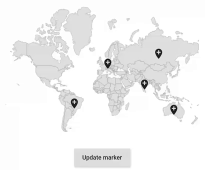
Updating the existing markers
You can update multiple markers at the same time by passing indices to the updateMarkers method in the MapShapeLayerController. The markerBuilder will be called again for the respective indices once the updateMarkers method is called.
NOTE
- You can get the current markers count from
MapShapeLayerController.markersCount.- You can refer to this
snippetto update the markers dynamically for tile layer.
late List<Model> _data;
late MapShapeLayerController _controller;
late Widget _markerWidget;
late MapShapeSource _dataSource;

@override
void initState() {
    _data = <Model>[
      Model(-14.235004, -51.92528),
      Model(51.16569, 10.451526),
      Model(-25.274398, 133.775136),
      Model(20.593684, 78.96288),
      Model(61.52401, 105.318756)
    ];

    _dataSource = MapShapeSource.asset(
       'assets/world_map.json',
        shapeDataField: 'name',
    );

    _controller = MapShapeLayerController();
    _markerWidget =  Icon(Icons.add_location);
    super.initState();
}

@override
Widget build(BuildContext context) {
    return Scaffold(
      body: Center(
          child: Container(
            height: 350,
            child: Padding(
              padding: EdgeInsets.only(left: 15, right: 15),
              child: Column(
                children: [
                  SfMaps(
                    layers: <MapLayer>[
                      MapShapeLayer(
                        source: _dataSource,
                        initialMarkersCount: 5,
                        markerBuilder: (BuildContext context, int index){
                          return MapMarker(
                            latitude: _data[index].latitude,
                            longitude: _data[index].longitude,
                            child: _markerWidget,
                          );
                        },
                        controller: _controller,
                      ),
                    ],
                  ),
                  ElevatedButton(
                    child: Text('Update marker'),
                    onPressed: () {
                      List<int> updateList = <int>[1, 2];
                      _markerWidget = Icon(Icons.people);
                      _controller.updateMarkers(updateList);
                    },
                  ),
                ],
              ),
            ),
          )
      ),
   );
}

class Model {
  Model(this.latitude, this.longitude);

  final double latitude;
  final double longitude;
}
Deleting a marker
You can remove a marker at any index using the removeMarkerAt method.
NOTE
- You can get the current markers count from
MapShapeLayerController.markersCount.- You can refer to this
snippetto update the markers dynamically for tile layer.
late List<Model> _data;
late MapShapeLayerController _controller;
late MapShapeSource _dataSource;

@override
void initState() {
    _data = <Model>[
      Model(-14.235004, -51.92528),
      Model(51.16569, 10.451526),
      Model(-25.274398, 133.775136),
      Model(20.593684, 78.96288),
      Model(61.52401, 105.318756)
    ];

    _dataSource = MapShapeSource.asset(
       'assets/world_map.json',
       shapeDataField: 'name',
    );
    _controller = MapShapeLayerController();
    super.initState();
}

@override
Widget build(BuildContext context) {
    return Scaffold(
      body: Center(
          child: Container(
            height: 350,
            child: Padding(
              padding: EdgeInsets.only(left: 15, right: 15),
              child: Column(
                children: [
                  SfMaps(
                    layers: <MapLayer>[
                      MapShapeLayer(
                        source: _dataSource,
                        initialMarkersCount: 5,
                        markerBuilder: (BuildContext context, int index){
                          return MapMarker(
                            latitude: _data[index].latitude,
                            longitude: _data[index].longitude,
                            child: Icon(Icons.add_location),
                          );
                        },
                        controller: _controller,
                      ),
                    ],
                  ),
                  ElevatedButton(
                    child: Text('Remove marker'),
                    onPressed: () {
                      _controller.removeMarkerAt(4);
                    },
                  ),
                ],
              ),
            ),
          )
      ),
   );
}

class Model {
  Model(this.latitude, this.longitude);

  final double latitude;
  final double longitude;
}
Clearing the markers
You can clear all markers using the clearMarkers method.
NOTE
- You can get the current markers count from
MapShapeLayerController.markersCount.- You can refer to this
snippetto update the markers dynamically for tile layer.
late List<Model> _data;
late MapShapeLayerController _controller;
late MapShapeSource _dataSource;

@override
void initState() {
    _data = <Model>[
      Model(-14.235004, -51.92528),
      Model(51.16569, 10.451526),
      Model(-25.274398, 133.775136),
      Model(20.593684, 78.96288),
      Model(61.52401, 105.318756)
    ];

    _dataSource = MapShapeSource.asset(
       'assets/world_map.json',
        shapeDataField: 'name',
    );
    _controller = MapShapeLayerController();
    super.initState();
}

@override
Widget build(BuildContext context) {
    return Scaffold(
      body: Center(
          child: Container(
            height: 350,
            child: Padding(
              padding: EdgeInsets.only(left: 15, right: 15),
              child: Column(
                children: [
                  SfMaps(
                    layers: <MapLayer>[
                      MapShapeLayer(
                        source: _dataSource,
                        initialMarkersCount: 5,
                        markerBuilder: (BuildContext context, int index){
                          return MapMarker(
                            latitude: _data[index].latitude,
                            longitude: _data[index].longitude,
                            child: Icon(Icons.add_location),
                          );
                        },
                        controller: _controller,
                      ),
                    ],
                  ),
                  ElevatedButton(
                    child: Text('Clear marker'),
                    onPressed: () {
                      _controller.clearMarkers();
                    },
                  ),
                ],
              ),
            ),
          )
      ),
   );
}

class Model {
  Model(this.latitude, this.longitude);

  final double latitude;
  final double longitude;
}
Marker controller
You can position a marker at the tapped position by converting the touch pixel point into coordinates using the pixelToLatLng method of MapTileLayerController in the MapTileLayer and the MapShapeLayerController in the MapShapeLayer.
NOTE
This is applicable for both tile layer and shape layer.
Shape layer
late MapLatLng _markerPosition;
late _CustomZoomPanBehavior _mapZoomPanBehavior;
late MapShapeLayerController _controller;
late MapShapeSource _mapSource;

@override
void initState() {
   _controller = MapShapeLayerController();
   _mapZoomPanBehavior = _CustomZoomPanBehavior()
      ..zoomLevel = 1
      ..onTap = updateMarkerChange;
   _mapSource = MapShapeSource.asset(
      'assets/world_map.json',
      shapeDataField: 'continent',
   );
   super.initState();
}

void updateMarkerChange(Offset position) {
  _markerPosition = _controller.pixelToLatLng(position);

  /// Removed [MapShapeLayer.initialMarkersCount] property and updated
  /// markers only when the user taps.
  if (_controller.markersCount > 0) {
    _controller.clearMarkers();
   }
  _controller.insertMarker(0);
}

@override
Widget build(BuildContext context) {
  return Scaffold(
     body: Center(
        child: Container(
          height: 400,
          width: 400,
          child: MapShapeLayer(
            source: _mapSource,
            zoomPanBehavior: _mapZoomPanBehavior,
            controller: _controller,
            markerBuilder: (BuildContext context, int index) {
              return MapMarker(
                latitude: _markerPosition.latitude,
                longitude: _markerPosition.longitude,
                child: Icon(
                  Icons.location_on,
                  color: Colors.red,
                  size: 20,
                ),
              );
            },
          ),
        ),
      ),
   );
}

class _CustomZoomPanBehavior extends MapZoomPanBehavior {
  _CustomZoomPanBehavior();
  late MapTapCallback onTap;

  @override
  void handleEvent(PointerEvent event) {
    if (event is PointerUpEvent) {
      onTap(event.localPosition);
    }
    super.handleEvent(event);
  }
}

typedef MapTapCallback = void Function(Offset position);
Tile layer
late MapLatLng _markerPosition;
late _CustomZoomPanBehavior _mapZoomPanBehavior;
late MapTileLayerController _controller;

@override
void initState() {
   _controller = MapTileLayerController();
   _mapZoomPanBehavior = _CustomZoomPanBehavior()
      ..onTap = updateMarkerChange;
   super.initState();
}

void updateMarkerChange(Offset position) {
  _markerPosition = _controller.pixelToLatLng(position);

  /// Removed [MapTileLayer.initialMarkersCount] property and updated
  /// markers only when the user taps.
  if (_controller.markersCount > 0) {
    _controller.clearMarkers();
  }
  _controller.insertMarker(0);
}

@override
Widget build(BuildContext context) {
  return Scaffold(
     body: Center(
        child: Container(
          height: 400,
          width: 400,
          child: MapTileLayer(
            urlTemplate: 'https://tile.openstreetmap.org/{z}/{x}/{y}.png',
            zoomPanBehavior: _mapZoomPanBehavior,
            controller: _controller,
            markerBuilder: (BuildContext context, int index) {
              return MapMarker(
                  latitude: _markerPosition.latitude,
                  longitude: _markerPosition.longitude,
                  child: Icon(
                    Icons.location_on,
                    color: Colors.red,
                    size: 20,
                  ));
            },
          ),
        ),
      ),
   );
}

class _CustomZoomPanBehavior extends MapZoomPanBehavior {
  _CustomZoomPanBehavior();
  late MapTapCallback onTap;

  @override
  void handleEvent(PointerEvent event) {
    if (event is PointerUpEvent) {
      onTap(event.localPosition);
    }
    super.handleEvent(event);
  }
}

typedef MapTapCallback = void Function(Offset position);
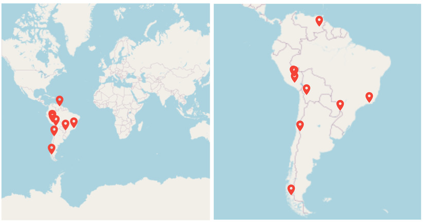
Zoom markers to fit bounds
You can visualize a specific area on the map by specifying the northeast and southwest coordinate points to the initialLatLngBounds property in the MapTileLayer and MapShapeLayer. It renders the map by calculating the center coordinate and zoom level depending on the initialLatLngBounds value.
The initialLatLngBounds property can be set at load time alone. You can use the latLngBounds property of MapZoomPanBehavior to dynamically update the map bounds.
late List<_TouristPlaceDetails> _touristPlaces;
late MapZoomPanBehavior _zoomPanBehavior;
bool _canFitMarkers = false;

@override
void initState() {
  _zoomPanBehavior = MapZoomPanBehavior();
  _touristPlaces = <_TouristPlaceDetails>[
    const _TouristPlaceDetails(
        MapLatLng(-25.6953, -54.4367), 'Iguazu Falls, Argentina'),
    const _TouristPlaceDetails(MapLatLng(-50.9423, -73.4068),
        'Torres del Paine National Park, Patagonia, Chile'),
    const _TouristPlaceDetails(
        MapLatLng(-15.9254, -69.3354), 'Lake Titicaca, Bolivia'),
    const _TouristPlaceDetails(
        MapLatLng(-13.1631, -72.5450), 'Machu Picchu, Peru'),
    const _TouristPlaceDetails(
        MapLatLng(-0.1862504, -78.5706247), 'The Amazon via Quito, Ecuador'),
    const _TouristPlaceDetails(
        MapLatLng(5.9701, -62.5362), 'Angel Falls, Venezuela'),
    const _TouristPlaceDetails(
        MapLatLng(-14.0875, -75.7626), 'Huacachina, Peru'),
    const _TouristPlaceDetails(
        MapLatLng(-22.7953, -67.8361), 'Laguna Verde, Bolivia'),
    const _TouristPlaceDetails(
        MapLatLng(-50.5025092, -73.1997346), 'Perito Moreno, Venezuela'),
    const _TouristPlaceDetails(
        MapLatLng(-22.9068, -43.1729), 'Rio de Janeiro, Brazil'),
    const _TouristPlaceDetails(
        MapLatLng(5.1765, -59.4808), 'Kaieteur Falls, Guyana'),
    const _TouristPlaceDetails(
        MapLatLng(-33.4489, -70.6693), 'Santiago, Chile'),
    const _TouristPlaceDetails(
        MapLatLng(4.7110, -74.0721), 'Bogota, Colombia'),
    const _TouristPlaceDetails(
        MapLatLng(-1.3928, -78.4269), 'Banos, Ecuador'),
  ];
  super.initState();
}

@override
Widget build(BuildContext context) {
  return Scaffold(
    body: Column(
      children: [
        SfMaps(
          layers: <MapLayer>[
            MapTileLayer(
              urlTemplate: 'https://tile.openstreetmap.org/{z}/{x}/{y}.png',
              zoomPanBehavior: _zoomPanBehavior,
              initialMarkersCount: _touristPlaces.length,
              markerBuilder: (BuildContext context, int index) {
                return MapMarker(
                  latitude: _touristPlaces[index].latLng.latitude,
                  longitude: _touristPlaces[index].latLng.longitude,
                  child: const Icon(
                    Icons.location_on,
                    color: Colors.red,
                    size: 20,
                  ),
                );
              },
            ),
          ],
        ),
        SizedBox(height: 10),
        Container(
          width: 300,
          padding: EdgeInsets.zero,
          child: CheckboxListTile(
            activeColor: Colors.blue,
            value: _canFitMarkers,
            title: Text('Zoom marker to fit bounds'),
            onChanged: (bool? value) {
              _canFitMarkers = value!;
              setState(() {
                if (_canFitMarkers) {
                  // South America bounds.
                  _zoomPanBehavior.latLngBounds = const MapLatLngBounds(
                      MapLatLng(12.434375, -34.80546874999999),
                      MapLatLng(-55.891699218750006, -91.654150390625));
                } else {
                  // World bounds.
                  _zoomPanBehavior.latLngBounds = const MapLatLngBounds(
                      MapLatLng(-90.0, -180.0), MapLatLng(90.0, 180.0));
                }
              });
            },
          ),
        ),
      ],
    ),
  );
}

class _TouristPlaceDetails {
  const _TouristPlaceDetails(this.latLng, this.place);
  final MapLatLng latLng;
  final String place;
}
NOTE
You can refer to our Flutter Maps feature tour page for its groundbreaking feature representations. You can also explore our Flutter Maps Markers example that shows how to configure a Maps in Flutter.