Data Labels in Flutter Maps (SfMaps)
28 Jul 202514 minutes to read
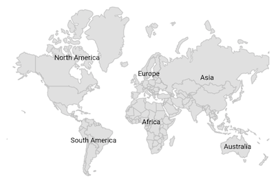
Data labels provide identification for the shapes by displaying their names. You can trim or hide the labels if they exceed the shape bounds.
Show data labels
You can show data labels on the map using the MapShapeLayer.showDataLabels property. By default, the data labels are rendered based on the value of shapeDataField property. The default value of the showDataLabels property is false.
late MapShapeSource dataSource;

@override
void initState() {
   dataSource = MapShapeSource.asset(
     "assets/world_map.json",
      shapeDataField: "continent",
   );
   super.initState();
}

@override
  Widget build(BuildContext context) {
    return Scaffold(
      body: Center(
        child: Padding(
          padding: EdgeInsets.only(left: 15, right: 15),
          child: SfMaps(
            layers: [
              MapShapeLayer(
                source: dataSource,
                showDataLabels: true,
              ),
            ],
        ),
      ),
    ),
  );
}
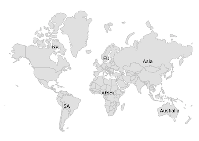
Text customization
You can customize text of the data labels using the MapShapeSource.dataLabelMapper property.
late List<Model> data;
late MapShapeSource dataSource;

@override
void initState() {
    super.initState();
    data = const <Model>[
      Model('Asia', 'Asia'),
      Model('Europe', 'EU'),
      Model('North America', 'NA'),
      Model('South America', 'SA'),
      Model('Australia', 'Australia'),
      Model('Africa', 'Africa')
    ];

    dataSource = MapShapeSource.asset(
       "assets/world_map.json",
       shapeDataField: "continent",
       dataCount: data.length,
       primaryValueMapper: (int index) => data[index].continent,
       dataLabelMapper: (int index) => data[index].code,
    );
}

@override
Widget build(BuildContext context) {
  return Scaffold(
    body: Center(
      child: Padding(
        padding: EdgeInsets.only(left: 15, right: 15),
        child: SfMaps(
          layers: [
            MapShapeLayer(
              source: dataSource,
              showDataLabels: true,
            ),
          ],
        ),
      ),
    ),
  );
}

class Model {
  const Model(this.continent, this.code);

  final String continent;
  final String code;
}
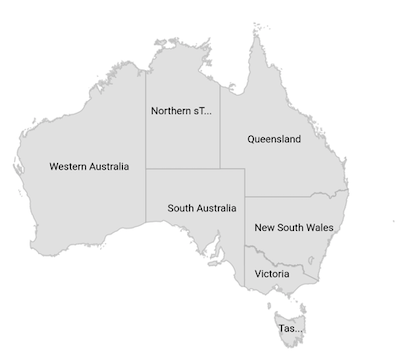
Overflow mode
You can trim or remove the data label when it is overflowed from the shape using the MapDataLabelSettings.overflowMode property. The possible values are visible, ellipsis, and hide. The default value of the overflowMode property is MapLabelOverflow.visible.
By default, the data labels will render even if they overflows from the shape.
late List<Model> data;
late MapShapeSource dataSource;

@override
void initState() {
    data = <Model>[
      Model('New South Wales', 'New South Wales'),
      Model('Queensland', 'Queensland'),
      Model('Northern Territory', 'Northern sTerritory'),
      Model('Victoria', 'Victoria'),
      Model('South Australia', 'South Australia'),
      Model('Western Australia', 'Western Australia'),
      Model('Tasmania', 'Tasmania'),
    ];

    dataSource = MapShapeSource.asset(
      'assets/australia.json',
      shapeDataField: 'STATE_NAME',
      dataCount: data.length,
      primaryValueMapper: (int index) => data[index].state,
      dataLabelMapper: (int index) => data[index].dataLabel,
    );
    super.initState();
}

@override
Widget build(BuildContext context) {
  return Scaffold(
    body: Center(
      child: Padding(
        padding: EdgeInsets.only(left: 15, right: 15),
        child: SfMaps(
          layers: [
            MapShapeLayer(
              source: dataSource,
              showDataLabels: true,
              dataLabelSettings: MapDataLabelSettings(
                overflowMode: MapLabelOverflow.ellipsis,
              ),
            ),
          ],
        ),
      ),
    ),
  );
}

class Model {
  Model(this.state, this.dataLabel);

  String state;
  String dataLabel;
}
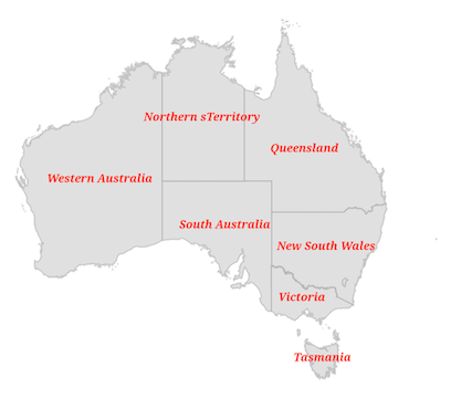
Appearance customization
You can customize the data labels using the MapDataLabelSettings.textStyle property.
late List<Model> data;
late MapShapeSource dataSource;

@override
void initState() {
    data = <Model>[
      Model('New South Wales', 'New South Wales'),
      Model('Queensland', 'Queensland'),
      Model('Northern Territory', 'Northern sTerritory'),
      Model('Victoria', 'Victoria'),
      Model('South Australia', 'South Australia'),
      Model('Western Australia', 'Western Australia'),
      Model('Tasmania', 'Tasmania'),
    ];

    dataSource = MapShapeSource.asset(
      'assets/australia.json',
      shapeDataField: 'STATE_NAME',
      dataCount: data.length,
      primaryValueMapper: (int index) => data[index].state,
      dataLabelMapper: (int index) => data[index].dataLabel,
    );
    super.initState();
}

@override
Widget build(BuildContext context) {
  return Scaffold(
    body: Center(
      child: Padding(
        padding: EdgeInsets.only(left: 15, right: 15),
        child: SfMaps(
          layers: [
            MapShapeLayer(
              source: dataSource,
              showDataLabels: true,
              dataLabelSettings: MapDataLabelSettings(
                textStyle: const TextStyle(
                    color: Colors.red,
                    fontSize: 12,
                    fontWeight: FontWeight.bold,
                    fontStyle: FontStyle.italic,
                    fontFamily: 'Times'),
              ),
            ),
          ],
        ),
      ),
    ),
  );
}

class Model {
  Model(this.state, this.dataLabel);

  String state;
  String dataLabel;
}
Using SfMapsTheme
You can also customize the data labels using the SfMapsThemeData.dataLabelTextStyle property in SfMapsTheme.
NOTE
You must import the
theme.dartlibrary from theCorepackage to useSfMapsTheme.
late List<Model> data;
late MapShapeSource dataSource;

@override
void initState() {
    data = <Model>[
      Model('New South Wales', 'New South Wales'),
      Model('Queensland', 'Queensland'),
      Model('Northern Territory', 'Northern sTerritory'),
      Model('Victoria', 'Victoria'),
      Model('South Australia', 'South Australia'),
      Model('Western Australia', 'Western Australia'),
      Model('Tasmania', 'Tasmania'),
    ];

    dataSource = MapShapeSource.asset(
       'assets/australia.json',
       shapeDataField: 'STATE_NAME',
       dataCount: data.length,
       primaryValueMapper: (int index) => data[index].state,
       dataLabelMapper: (int index) => data[index].dataLabel,
    );
    super.initState();
}

@override
Widget build(BuildContext context) {
  return Scaffold(
    body: Center(
      child: Padding(
        padding: EdgeInsets.only(left: 15, right: 15),
        child: SfMapsTheme(
          data: SfMapsThemeData(
            dataLabelTextStyle: TextStyle(
                color: Colors.red,
                fontSize: 12,
                fontWeight: FontWeight.bold,
                fontStyle: FontStyle.italic,
                fontFamily: 'Times'),
          ),
          child: SfMaps(
            layers: [
              MapShapeLayer(
                source: dataSource,
                showDataLabels: true,
              ),
            ],
          ),
        ),
      ),
    ),
  );
}

class Model {
   Model(this.state, this.dataLabel);

   String state;
   String dataLabel;
}