Layers in WPF Maps (SfMap)
9 Jul 202624 minutes to read
The WPF Maps control is maintained through Layers, a map can accommodate one or more layers.
The maps control consists of the following two layers:
-
Imagery layer
-
Shape file layer
Imagery layer
The MapsProvider section explains about the imagery layer.
Shape file layer
Using shape file layer, custom shape files can be rendered and the shapes can be customized.
Shape settings
This section defines how to customize the shapes in a map.
You can customize a shape’s fill, stroke, and stroke thickness using the ShapeFill, ShapeStroke, and ShapeStrokeThickness properties.
Refer to the following code sample for customizing shapes.
<maps:SfMap>
            <maps:SfMap.Layers >
                <maps:ShapeFileLayer Uri="GettingStarted.ShapeFiles.usa_state.shp" >
                    <maps:ShapeFileLayer.ShapeSettings>
                        <maps:ShapeSetting  ShapeFill="LightBlue" ShapeStroke="Black" ShapeStrokeThickness="1" >
                        </maps:ShapeSetting>
                    </maps:ShapeFileLayer.ShapeSettings>
                </maps:ShapeFileLayer>
            </maps:SfMap.Layers>
        </maps:SfMap>
SfMap maps = new SfMap();
ShapeFileLayer shapeLayer = new ShapeFileLayer();
shapeLayer.Uri = "GettingStarted.ShapeFiles.usa_state.shp";
ShapeSetting shapeSetting = new ShapeSetting();
shapeSetting.ShapeFill = new SolidColorBrush(Colors.LightBlue);
shapeSetting.ShapeStroke = new SolidColorBrush(Colors.Black);
shapeSetting.ShapeStrokeThickness = 1;
shapeLayer.ShapeSettings = shapeSetting;
maps.Layers.Add(shapeLayer);
this.Content = maps;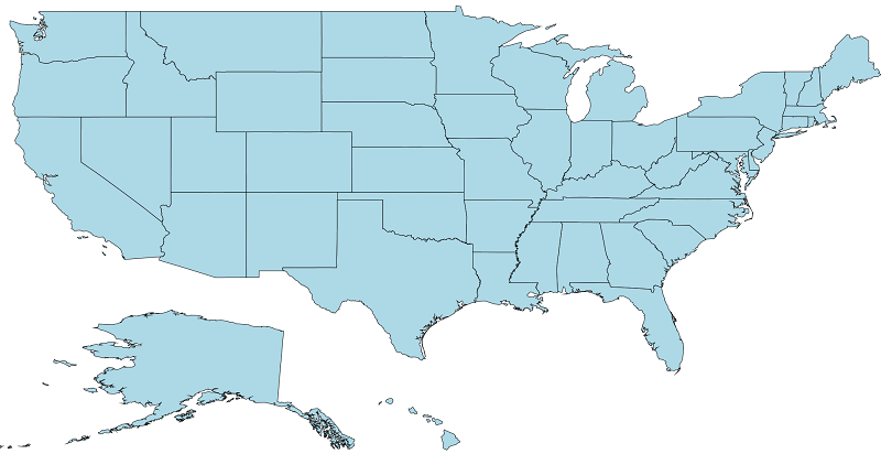
Customize selected shapes
The shape selection is enabled when the EnableSelection property is set to true. To customize the selected shapes alone, use the following properties:
SelectedShapeColor: Sets the color for selected shapes in a map.
SelectedShapeStroke: Sets the border color for selected shapes in a map.
SelectedShapeStrokeThickness: Sets the border thickness for selected shapes in a map.
<syncfusion:SfMap >
            <syncfusion:SfMap.Layers>
                <syncfusion:ShapeFileLayer EnableSelection="True"  Uri="GettingStarted.ShapeFiles.usa_state.shp">
                    <syncfusion:ShapeFileLayer.ShapeSettings>
                        <syncfusion:ShapeSetting  SelectedShapeColor="Green" SelectedShapeStroke="Black" ShapeStrokeThickness="1" >
                        </syncfusion:ShapeSetting>
                    </syncfusion:ShapeFileLayer.ShapeSettings>
                </syncfusion:ShapeFileLayer>
            </syncfusion:SfMap.Layers>
        </syncfusion:SfMap>
SfMap maps = new SfMap();
ShapeFileLayer shapeLayer = new ShapeFileLayer();
shapeLayer.EnableSelection = true;
shapeLayer.Uri = "GettingStarted.ShapeFiles.usa_state.shp";
ShapeSetting shapeSetting = new ShapeSetting();
shapeSetting.SelectedShapeColor = new SolidColorBrush(Colors.Green);
shapeSetting.SelectedShapeStroke = new SolidColorBrush(Colors.Black);
shapeSetting.SelectedShapeStrokeThickness = 1;
shapeLayer.ShapeSettings = shapeSetting;
maps.Layers.Add(shapeLayer);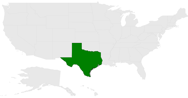
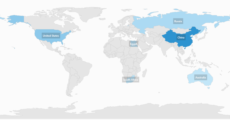
Appearance customization
ItemsTemplate is a type of DataTemplate that is used to override the default template for map items. Data is the property that holds the object for a map item.
<syncfusion:SfMap>
            <syncfusion:SfMap.Layers>
                <syncfusion:ShapeFileLayer Background="White" ItemsSource="{Binding Countries}"
                                           ShapeIDPath="Name" ShapeIDTableField="NAME"
                                           Uri="DataMarkers.ShapeFiles.world1.shp">
                    <syncfusion:ShapeFileLayer.ItemsTemplate>
                        <DataTemplate>
                            <Grid Background="#332D2D2D">
                                <TextBlock Margin="5" Foreground="White" Opacity="1" FontSize="12"
                                           FontWeight="SemiBold" FontFamily="Segoe UI"
                                           Text="{Binding Data.Name}"/>
                            </Grid>
                        </DataTemplate>
                    </syncfusion:ShapeFileLayer.ItemsTemplate>
                    <syncfusion:ShapeFileLayer.ShapeSettings>
                        <syncfusion:ShapeSetting ShapeFill="#E5E5E5" ShapeStroke="#C1C1C1"
                                                 ShapeStrokeThickness="0.5" ShapeValuePath="Population"
                                                 ShapeColorValuePath="Population" >
                            <syncfusion:ShapeSetting.FillSetting>
                                <syncfusion:ShapeFillSetting AutoFillColors="False">
                                    <syncfusion:ShapeFillSetting.ColorMappings>
                                        <syncfusion:RangeColorMapping To="1500000000" From="750000000" Color="#2A91CF"/>
                                        <syncfusion:RangeColorMapping To="750000000" From="1000" Color="#3D9FD8"/>
                                        <syncfusion:RangeColorMapping From="0" To="1000" Color="#C7E9FA"/>
                                    </syncfusion:ShapeFillSetting.ColorMappings>
                                </syncfusion:ShapeFillSetting>
                            </syncfusion:ShapeSetting.FillSetting>
                        </syncfusion:ShapeSetting>
                    </syncfusion:ShapeFileLayer.ShapeSettings>
                </syncfusion:ShapeFileLayer>
            </syncfusion:SfMap.Layers>
        </syncfusion:SfMap>
public class Country
{
private string name;
public string Name
{
get { return name; }
set { name = value; }
}
private double population;
public double Population
{
get { return population; }
set { population = value; }
}
}
public class ViewModel
{
private ObservableCollection<Country> countries;
public ObservableCollection<Country> Countries
{
get { return countries; }
set { countries = value; }
}
public ViewModel()
{
Countries = new ObservableCollection<Country>
{
new Country { Name = "Russia", Population = 143228300},
new Country { Name = "China", Population = 1347350000 },
new Country { Name = "Australia", Population = 22789701 },
new Country { Name = "South Africa", Population = 50586757},
new Country { Name = "United States", Population = 314623000 },
new Country { Name = "Egypt", Population = 82724000},
};
}
}
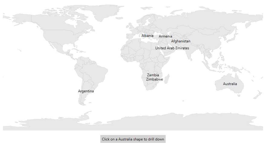
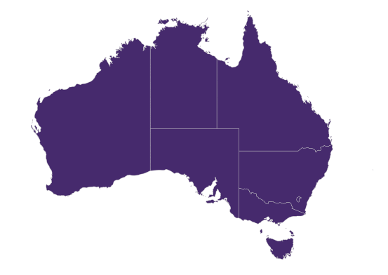
ZOrder index for layers
The BaseMapIndex property allows drill-down from main layer to another layer.
In the ShapeSelected event, the BaseMapIndex property has been used to change the layer when Australia shape is selected.
<Grid>
        <Grid.RowDefinitions>
            <RowDefinition/>
            <RowDefinition Height="Auto"/>
        </Grid.RowDefinitions>
        <Grid.DataContext>
            <local:DrilldownViewModel/>
        </Grid.DataContext>

        <maps:SfMap x:Name="map">
            <maps:SfMap.Layers>
                <maps:ShapeFileLayer EnableSelection="True" x:Name="layer1" Uri="DataMarkers.ShapeFiles.world1.shp"
                                     ItemsSource="{Binding DataSource}" ShapeIDPath="Country"
                                     ShapeIDTableField="NAME"
                                     ShapesSelected="layer1_ShapesSelected">
                    <maps:ShapeFileLayer.ShapeSettings>
                        <maps:ShapeSetting  ShapeColorValuePath="Country" ShapeValuePath="Country">
                        </maps:ShapeSetting>
                    </maps:ShapeFileLayer.ShapeSettings>
                    <maps:ShapeFileLayer.ItemsTemplate>
                        <DataTemplate>
                            <TextBlock Text="{Binding Data.Country}" IsHitTestVisible="False"/>
                        </DataTemplate>
                    </maps:ShapeFileLayer.ItemsTemplate>
                </maps:ShapeFileLayer>
                <maps:ShapeFileLayer x:Name="layer2" Uri="DataMarkers.ShapeFiles.australia.shp">
                    <maps:ShapeFileLayer.ShapeSettings>
                        <maps:ShapeSetting ShapeFill="#462A6D"/>
                    </maps:ShapeFileLayer.ShapeSettings>
                </maps:ShapeFileLayer>
            </maps:SfMap.Layers>
        </maps:SfMap>
        <Label x:Name="label" Grid.Row="1"
               HorizontalAlignment="Center" Background="LightGray" Margin="10"
               Content="Click on an Australia shape to drill down"/>
    </Grid>
private void layer1_ShapesSelected(object sender, SelectionEventArgs args)
{
MapShape mapShape = (args.Items as ObservableCollection<MapShape>)[0];
if (mapShape != null)
{
if (mapShape.ShapeValue.ToString() == "Australia")
{
this.map.BaseMapIndex = 1;
label.Visibility = Visibility.Collapsed;
}
}
}
public class DrilldownViewModel
{
public DrilldownViewModel()
{
DataSource = new ObservableCollection<DrilldownModel>();
DataSource.Add(new DrilldownModel("Afghanistan", "Asia"));
DataSource.Add(new DrilldownModel("Albania", "Europe"));
DataSource.Add(new DrilldownModel("United Arab Emirates", "Asia"));
DataSource.Add(new DrilldownModel("Argentina", "South America"));
DataSource.Add(new DrilldownModel("Armenia", "Asia"));
DataSource.Add(new DrilldownModel("French Southern and Antarctic Lands", "Seven seas (open ocean)"));
DataSource.Add(new DrilldownModel("Australia", "Australia"));
//..
//..
DataSource.Add(new DrilldownModel("Zambia", "Africa"));
DataSource.Add(new DrilldownModel("Zimbabwe", "Africa"));
}
public ObservableCollection<DrilldownModel> DataSource { get; set; }
}
public class DrilldownModel
{
public DrilldownModel(string country, string con)
{
this.Country = country;
this.Continent = con;
}
public string Continent
{
get;
set;
}
public string Country
{
get;
set;
}
}
Events
The ShapeSelected event will be triggered when a map shape is selected. A corresponding model data is passed as an argument.
The ShapesUnSelected event will be triggered when a map shape is unselected. A corresponding model data is passed as an argument.
<syncfusion:SfMap >
            <syncfusion:SfMap.Layers>
                <syncfusion:ShapeFileLayer EnableSelection="True"  Uri="GettingStarted.ShapeFiles.usa_state.shp"  ShapesSelected="ShapeFileLayer_ShapesSelected" ShapesUnSelected="ShapeFileLayer_ShapesUnSelected">
                 </syncfusion:ShapeFileLayer>
            </syncfusion:SfMap.Layers>
        </syncfusion:SfMap>
public partial class MainWindow : Window
{
public MainWindow()
{
InitializeComponent();
SfMap maps = new SfMap();
ShapeFileLayer shapeLayer = new ShapeFileLayer();
shapeLayer.ShapesUnSelected += ShapeFileLayer_ShapesUnSelected;
shapeLayer.ShapesSelected += ShapeFileLayer_ShapesSelected;
shapeLayer.EnableSelection = true;
shapeLayer.Uri = "GettingStarted.ShapeFiles.usa_state.shp";
maps.Layers.Add(shapeLayer);
this.Content = maps;
}
private void ShapeFileLayer_ShapesSelected(object sender, SelectionEventArgs args)
{
var data = args.Items;
}
private void ShapeFileLayer_ShapesUnSelected(object sender, SelectionEventArgs args)
{
var data = args.Items;
}
}NOTE
You can also explore our WPF Map example to know how to render and configure the map.
See also
How to customize the markers in maps