Maps Providers in Xamarin.Forms Maps (SfMaps)
8 Jan 202524 minutes to read
Xamarin maps control supports map providers such as OpenStreetMap and Bing Maps that can be added to an imagery layer in maps.
OpenStreetMap
The OpenStreetMap (OSM) is a world map; it was built by a community of mappers. It is free to use under an open license. This allows you to view geographical data in a collaborative way from anywhere on the earth. The OSM provides small tile images based on your requests and combines them into a single image to display the map area in the maps control.
Adding OSM in maps
The maps control uses ImageryLayer to display the tile images from the OSM service. To use OSM, add an ImageryLayer in maps’ layers collection.
<maps:SfMaps.Layers>
            <maps:ImageryLayer/>
        </maps:SfMaps.Layers>
SfMaps maps = new SfMaps();
ImageryLayer layer = new ImageryLayer();
maps.Layers.Add(layer);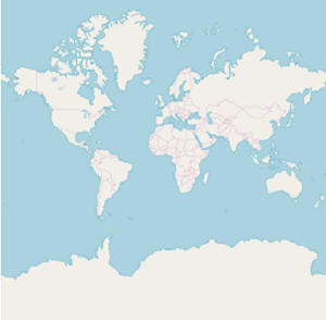
NOTE
Both the
ShapeFileLayerandImageryLayerhave been derived commonly from MapsLayer.
Bing Maps
The Bing Maps is a world map owned by Microsoft. As OSM, Bing Maps also provides the map tile images based on your requests and combines them into a single image to display the map area. To use Bing maps, set the LayerType property of ImageryLayer to “Bing”. Then, set the Bing Maps key, which is obtained from Bing Maps Key.
<maps:SfMaps.Layers>
        <maps:ImageryLayer LayerType="Bing" BingMapKey="Your bing map key"/>
    </maps:SfMaps.Layers>
SfMaps maps = new SfMaps();
ImageryLayer layer = new ImageryLayer();
layer.LayerType = LayerType.Bing;
layer.BingMapKey = "Your bing map key";
maps.Layers.Add(layer);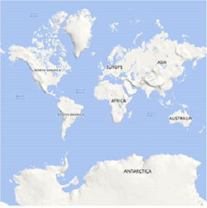
NOTE
The
LayerTypeproperty ofImageryLayerprovides the support toOSMandBing Maps. The default value of theLayerTypeproperty is OSM.
Set different bing map style
The ImageryLayer provides the support to the following types of Bing Maps:
RoadAerialAerialWithLabels
The desired style for the Bing Maps can be set using the BingMapStyle property of ImageryLayer. The default value of BingMapStyle is Road.
Road
The Road view displays the default map view of roads, buildings, and geography. The default value of the BingMapStyle property of imagery layer is Road.
Aerial
The Aerial view displays the satellite images to highlight the roads and major landmarks for easy identification. The aerial view can be applied to maps by setting the BingMapStyle to Aerial.
<maps:SfMaps.Layers>
            <maps:ImageryLayer LayerType="Bing"
                            BingMapStyle="Aerial"
                            BingMapKey=" Your bing map key "/>
        </maps:SfMaps.Layers>
SfMaps maps = new SfMaps();
ImageryLayer layer = new ImageryLayer();
layer.LayerType = LayerType.Bing;
layer.BingMapStyle = BingMapStyle.Aerial;
layer.BingMapKey = "Your bing map key ";
maps.Layers.Add(layer);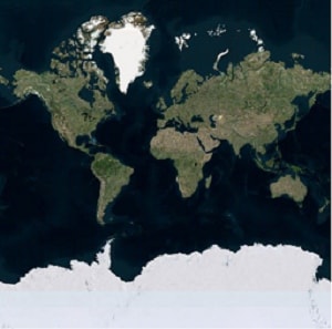
AerialWithLabel
The AerialWithLabel view displays the Aerial map with labels for continent, country, ocean, etc. This view can be applied to maps by setting the BingMapStyle to AerialWithLabel.
<maps:SfMaps.Layers>
            <maps:ImageryLayer LayerType="Bing"
                            BingMapStyle="AerialWithLabels"
                            BingMapKey=" Your bing map key "/>
        </maps:SfMaps.Layers>
SfMaps maps = new SfMaps();
ImageryLayer layer = new ImageryLayer();
layer.LayerType = LayerType.Bing;
layer.BingMapStyle = BingMapStyle.AerialWithLabels;
layer.BingMapKey = "Your bing map key ";
maps.Layers.Add(layer);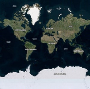
Zooming and panning
The maps control provides the interactive zooming and panning supports to OSM and Bing Maps.
Zooming helps you to get a closer look of an area on maps for in-depth analysis. Panning helps you to move a map around to focus the targeted area. You can perform zooming and panning with the pinching gesture in a map area.
Reset zooming
The ImageryLayer provides the support to reset the maps to the default view when you double tap the imagery layer by setting the ResetOnDoubleTap property to true. The default value of this property is true. This behavior can be restricted by setting the ResetOnDoubleTap property to false.
<maps:SfMaps>
        <maps:SfMaps.Layers>
                <maps:ImageryLayer ResetOnDoubleTap="True"/>
            </maps:SfMaps.Layers>
        </maps:SfMaps>
SfMaps maps = new SfMaps();
ImageryLayer layer = new ImageryLayer();
layer.ResetOnDoubleTap = true;
maps.Layers.Add(layer);Set Geo coordinates points(center position)
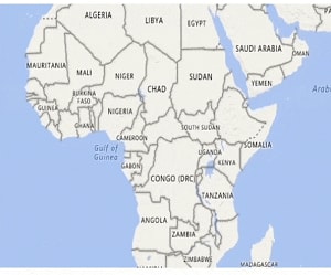
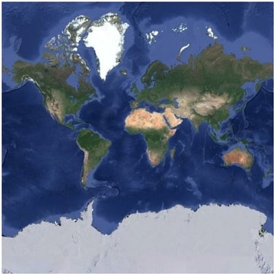
The GeoCoordinates (center) property allows you view the desired area at the center on loading. By default, the GeoCoordinates value is (0,0). So, first parameter of the latitude value “0” and second parameter of the longitude value “0” are shown at the center.
On changing the GeoCoordinates point dynamically, map will provide transition animation from the previous geo coordinates to the new geo coordinates value.
<maps:SfMaps ZoomLevel="2">
                <maps:SfMaps.Layers>
                    <maps:ImageryLayer GeoCoordinates="69.07,-37.08"/>
                </maps:SfMaps.Layers>
            </maps:SfMaps>
SfMaps maps = new SfMaps();
maps.ZoomLevel = 2;
ImageryLayer layer = new ImageryLayer();
layer.GeoCoordinates = new Point(69.07, -37.08);
maps.Layers.Add(layer);
<maps:SfMaps ZoomLevel="2">
            <maps:SfMaps.Layers>
                <maps:ImageryLayer GeoCoordinates="0,0"/>
            </maps:SfMaps.Layers>
        </maps:SfMaps>
SfMaps maps = new SfMaps();
maps.ZoomLevel = 2;
ImageryLayer layer = new ImageryLayer();
layer.GeoCoordinates = new Point(0,0);
maps.Layers.Add(layer);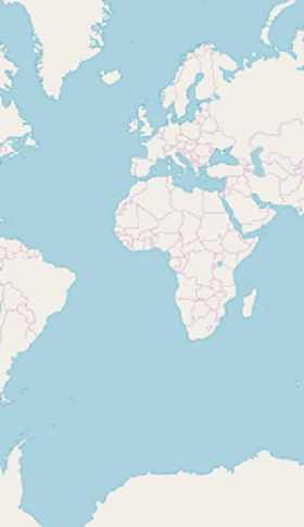
Set markers in imagery layer
As ShapeFileLayer, markers also can be added to imagery layer. Markers can be customized using the MarkerSettings property in ImageryLayer.
The detailed explanation of marker and its customization have been provided in Markers section.
<maps:ImageryLayer  >
            <maps:ImageryLayer.MarkerSettings>
                <maps:MapMarkerSetting IconColor="Red"
                                    IconSize="13" MarkerIcon="Diamond"/>
            </maps:ImageryLayer.MarkerSettings>
                        <maps:ImageryLayer.Markers>
                            <maps:MapMarker  Label="United States" Latitude="40"
                                            Longitude= "-101"/>
                            <maps:MapMarker Label="Brazil" Latitude="-15.7833"
                                            Longitude= "-52" />
                            <maps:MapMarker Label="Congo" Latitude="-1.6"
                                            Longitude= "24.4" />
                            <maps:MapMarker Label="Kazakhstan" Latitude="49.9"
                                            Longitude= "72.23" />
                            <maps:MapMarker Label="Australia" Latitude="-20.54"
                                            Longitude= "134.10" />
                    </maps:ImageryLayer.Markers>
                </maps:ImageryLayer>
ImageryLayer layer = new ImageryLayer();
layer.MarkerSettings = new MapMarkerSetting();
layer.MarkerSettings.IconColor = Color.Red;
layer.MarkerSettings.MarkerIcon = MapMarkerIcon.Diamond;
layer.MarkerSettings.IconSize = 13;
MapMarker marker1 = new MapMarker();
marker1.Label = "United States";
marker1.Latitude = "40";
marker1.Longitude = "-101";
layer.Markers.Add(marker1);
MapMarker marker2 = new MapMarker();
marker2.Label = "Brazil";
marker2.Latitude = "-15.7833";
marker2.Longitude = "-52";
layer.Markers.Add(marker2);
MapMarker marker3 = new MapMarker();
marker3.Label = "Congo";
marker3.Latitude = "-1.6";
marker3.Longitude = "24.4";
layer.Markers.Add(marker3);
MapMarker marker4 = new MapMarker();
marker4.Label = "Kazakhstan";
marker4.Latitude = "49.9";
marker4.Longitude = "72.23";
layer.Markers.Add(marker4);
MapMarker marker5 = new MapMarker();
marker5.Label = "Australia";
marker5.Latitude = "-20.54";
marker5.Longitude = "134.10";
layer.Markers.Add(marker5);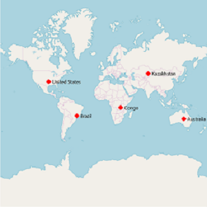
Load custom map
You can load the custom map providers map such as Google Maps, TomTom using the RequestTileUri event of ImageryLayer. For more details about RequestTileUri, refer the Events of ImageryLayer.
<maps:SfMaps>
   <maps:SfMaps.Layers>
         <maps:ImageryLayer RequestTileUri="ImageryLayer_RequestTileUri">
          </maps:ImageryLayer>
    </maps:SfMaps.Layers>
</maps:SfMaps>
SfMaps maps = new SfMaps();
ImageryLayer layer = new ImageryLayer();
layer.RequestTileUri += ImageryLayer_RequestTileUri;
maps.Layers.Add(layer);
private void ImageryLayer_RequestTileUri(object sender, Syncfusion.SfMaps.XForms.TileUriArgs e)
{
var link = "http://mt1.google.com/vt/lyrs=y&x=" + e.X.ToString() + "&y=" + e.Y.ToString() + "&z=" + e.ZoomLevel.ToString();
e.Uri = link;
}See also this KB article to load the google map.
Cache a tile images in application memory
The CanCacheTiles property used to decide whether the tile images should be cached in application memory or not.
ImageryLayer imageryLayer = new ImageryLayer();

       imageryLayer.CanCacheTiles = true;
Calculate a zoom level based on map geo-bounds or distance
This feature is used to calculate the initial zoom level automatically in two ways:
- Distance in radius(Meter/KiloMeter/Mile)
- Geo-bounds(Northeast, Southwest)
Distance in radius
Calculate the initial zoom level automatically based on the Radius and DistanceType properties of imagery layer class.
NOTE
DistanceTypeproperty default value is KiloMeter.
<ContentPage.Resources>
            <ResourceDictionary>
                <DataTemplate x:Key="markerTemplate">
                    <StackLayout IsClippedToBounds="false" HorizontalOptions="StartAndExpand" VerticalOptions="Center" HeightRequest="35">
                    <Image Source="pin.png" Scale="1" Aspect="AspectFit " HorizontalOptions="StartAndExpand" VerticalOptions="Center"  HeightRequest="35" WidthRequest="25" />
                    </StackLayout>
                </DataTemplate>
            </ResourceDictionary>
        </ContentPage.Resources>

    <maps:SfMaps  x:Name="Map" >
        <maps:SfMaps.Layers >
            <maps:ImageryLayer MarkerSelected="Layer_MarkerSelected" GeoCoordinates = "38.909804, -77.043442" Radius="5" DistanceType="KiloMeter" MarkerTemplate="{StaticResource Key=markerTemplate}">
                <maps:ImageryLayer.Markers>
                    <maps:MapMarker Latitude= "38.909804" Longitude= "-77.043442"/>
                </maps:ImageryLayer.Markers>
            </maps:ImageryLayer>
        </maps:SfMaps.Layers>
    </maps:SfMaps>
SfMaps maps = new SfMaps();
ImageryLayer layer = new ImageryLayer();
layer.GeoCoordinates = new Point(38.909804, -77.043442);
layer.Radius = 5;
layer.DistanceType = DistanceType.KiloMeter;
MapMarker marker = new MapMarker();
marker.Latitude = "38.909804";
marker.Longitude = "-77.043442";
layer.MarkerTemplate = this.Resources["markerTemplate"] as DataTemplate;
layer.Markers.Add(marker);
maps.Layers.Add(layer);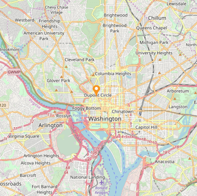
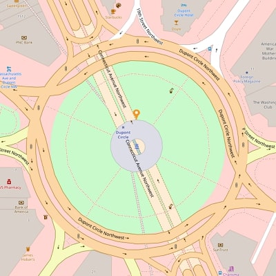
Geo-bounds
Calculate the initial zoom level automatically based on the LatLngBounds(Northeast, Southwest) of ImageryLayer class.
<ContentPage.Resources>
        <ResourceDictionary>
            <DataTemplate x:Key="markerTemplate">
                <StackLayout IsClippedToBounds="false" HorizontalOptions="StartAndExpand" VerticalOptions="Center" HeightRequest="35">
                    <Image Source="pin.png" Scale="1" Aspect="AspectFit " HorizontalOptions="StartAndExpand" VerticalOptions="Center"  HeightRequest="35" WidthRequest="25" />
                </StackLayout>
            </DataTemplate>
        </ResourceDictionary>
    </ContentPage.Resources>

    <maps:SfMaps>
        <maps:SfMaps.Layers>
            <maps:ImageryLayer MarkerTemplate="{StaticResource Key=markerTemplate}">
                <maps:ImageryLayer.Markers>
                    <maps:MapMarker Latitude= "38.909804" Longitude= "-77.043442"/>
                </maps:ImageryLayer.Markers>
                <maps:ImageryLayer.LatLngBounds>
                    <maps:LatLngBounds>
                        <maps:LatLngBounds.Northeast>
                            <maps:Position>
                                <x:Arguments>
                                    <x:Double>38.909804</x:Double>
                                    <x:Double>-77.043442</x:Double>
                                </x:Arguments>
                            </maps:Position>
                        </maps:LatLngBounds.Northeast>
                        <maps:LatLngBounds.Southwest>
                            <maps:Position>
                                <x:Arguments>
                                    <x:Double>38.909804</x:Double>
                                    <x:Double>-77.043442</x:Double>
                                </x:Arguments>
                            </maps:Position>
                        </maps:LatLngBounds.Southwest>
                    </maps:LatLngBounds>
                </maps:ImageryLayer.LatLngBounds>
            </maps:ImageryLayer>
        </maps:SfMaps.Layers>
    </maps:SfMaps>
SfMaps maps = new SfMaps();
ImageryLayer layer = new ImageryLayer();
LatLngBounds bounds = new LatLngBounds();
bounds.Northeast = new Position(38.909804, -77.043442);
bounds.Southwest = new Position(38.909804, -77.043442);
layer.LatLngBounds = bounds;
MapMarker marker = new MapMarker();
marker.Latitude = "38.909804";
marker.Longitude = "-77.043442";
layer.MarkerTemplate = this.Resources["markerTemplate"] as DataTemplate;
maps.Layers.Add(layer);NOTE
When setting
LatLngBoundsandDistanceRadiusat the same time, the priority isDistanceRadiusand calculate zoom level based radius value.
Get the map tile layer bounds
You can get imagery layer pixel bounds by using MapBounds property while zooming, panning, and changing Geo-Coordinate value in imagery layer.
<maps:SfMaps >
        <maps:SfMaps.Layers>
            <maps:ImageryLayer x:Name="layer"  GeoCoordinates="30.9709225, -100.2187212" GeoCoordinateChanged="layer_GeoCoordinateChanged">
            </maps:ImageryLayer>
        </maps:SfMaps.Layers>
    </maps:SfMaps>
public partial class MapBound : ContentPage
{
ImageryLayer layer = new ImageryLayer();
public MapBound()
{
InitializeComponent();
SfMaps maps = new SfMaps();
layer.GeoCoordinates = new Point(30.9709225, -100.2187212);
layer.GeoCoordinateChanged += Layer_GeoCoordinateChanged;
maps.Layers.Add(layer);
this.Content = maps;
}
private void Layer_GeoCoordinateChanged(object sender, GeoCoordinateChangedEventArgs e)
{
var pixelBounds = layer.MapBounds;
}
}Clear a cached tile images from application memory
The DeleteTilesFromCache method used to clear the cached tile images from application cache memory.
<maps:SfMaps>
            <maps:SfMaps.Layers>
                <maps:ImageryLayer x:Name="imageryLayer" />
            </maps:SfMaps.Layers>
</maps:SfMaps>imageryLayer.DeleteTilesFromCache();Events
The RequestTileUriArgs event is triggered whenever new tile required for map(such as zooming, panning and initial time).
The following arguments can be obtained from the RequestTileUri event:
-
Uri– Provide the option to set the desired Uri to load the custom map. -
UriRequestTask– Used to gets or sets the requested uri task asynchronously to load the custom map. -
X– Used to gets the X Co-ordinate value of the tile image. -
Y– Used to gets the Y Co-ordinate value of the tile image. -
ZoomLevel– Used to gets the current zoom level value of the tile image.
<maps:SfMaps>
   <maps:SfMaps.Layers>
         <maps:ImageryLayer RequestTileUri="ImageryLayer_RequestTileUri">
          </maps:ImageryLayer>
    </maps:SfMaps.Layers>
</maps:SfMaps>
private void ImageryLayer_RequestTileUri(object sender, Syncfusion.SfMaps.XForms.TileUriArgs e)
{
var link = "http://mt1.google.com/vt/lyrs=y&x=" + e.X.ToString() + "&y=" + e.Y.ToString() + "&z=" + e.ZoomLevel.ToString();
e.Uri = link;
}The ZoomLevelChanging event triggers when zoom level changed. Following arguments can be get from the ZoomLevelChanging event .
-
Cancel: Used to cancel the zooming. -
PreviousLevel: Returns the previous level after the zooming. -
CurrentLevel: Returns the current level to be zoomed.
<maps:SfMaps>
            <maps:SfMaps.Layers>
                <maps:ImageryLayer  ZoomLevelChanging="Layer_ZoomLevelChanging" />
            </maps:SfMaps.Layers>
        </maps:SfMaps>
private void Layer_ZoomLevelChanging(object sender, ZoomLevelChangingEventArgs e)
{
if(e.PreviousLevel == 10) // Returns the previous zoom level
{
e.Cancel = true; // Cancels the zooming event
var CurrentLevel = e.CurrentLevel; // Returns the current zoomed level
}
}The GeoCoordinateChanged event is triggered while zooming and panning the maps.
The following arguments can be gotten from the ImageryLayer_GeoCoordinateChanged event:
-
Center: Returns the center Geo coordinate point of the visual tiles while zooming and panning. -
TopLeft: Returns the top-left Geo coordinate point of the visual tiles while zooming and panning. -
TopRight: Returns the top-right Geo coordinate point of the visual tiles while zooming and panning. -
BottomLeft: Returns the bottom-left Geo coordinate point of the visual tiles while zooming and panning. -
BottomRight: Returns the bottom-right Geo coordinate point of the visual tiles while zooming and panning.
<maps:SfMaps >
    <maps:SfMaps.Layers >
        <maps:ImageryLayer GeoCoordinateChanged="ImageryLayer_GeoCoordinateChanged"/>
    </maps:SfMaps.Layers>
</maps:SfMaps>
private void ImageryLayer_GeoCoordinateChanged(object sender, GeoCoordinateChangedEventArgs e)
{
var topLeft = e.TopLeft;
var topRight = e.TopRight;
var bottomLeft = e.BottomLeft;
var bottomRight = e.BottomRight;
var center = e.Center;
}NOTE
You can also explore our Xamarin.Forms Maps example to knows the functionalities of each feature.
See Also
How to show the current GPS location in Xamarin.Forms SfMaps
How to use Google Maps API to show Google Maps in Xamarin.Forms SfMaps control
How to group the markers based on zoom level in the imagery layer of the SfMaps control
How to add sub shape file layer for ImageryLayer in Xamarin.Forms SfMaps