How can I help you?
Bubble Marker in Xamarin.Forms Maps (SfMaps)
8 Jan 202519 minutes to read
Bubbles in the Xamarin Maps control represent the underlying data values of the maps. Bubbles are scattered throughout the map shapes that contain bound values.
Bubble data
Bubbles are included when the data binding and BubbleMarkerSettings are set to the shape layers.
The following code sample explains data binding provided for bubble.
<maps:SfMaps x:Name="map">
    <maps:SfMaps.Layers>
        <maps:ShapeFileLayer
            Uri="usa_state.shp"
            ShapeIDPath="Name"
            ShapeIDTableField="STATE_NAME"
            ItemsSource="{Binding DataSource}" />
    </maps:SfMaps.Layers>
</maps:SfMaps>
ShapeFileLayer layer = new ShapeFileLayer()
{
Uri = "usa_state.shp",
ItemsSource = viewModel.DataSource,
ShapeIDTableField = "STATE_NAME",
ShapeIDPath = "Name"
};
map.Layers.Add(layer);Adding bubbles
To add bubbles to maps, the bubble marker setting should be added to the shape file layer. The ShowBubbles property should be enabled for making the bubbles visible.
The ValuePath represents the field value to be fetched from the data for each bubble.
<maps:ShapeFileLayer.BubbleMarkerSettings>
    <maps:BubbleMarkerSetting ShowBubbles="True"  ValuePath="index" />
</maps:ShapeFileLayer.BubbleMarkerSettings>
BubbleMarkerSetting bubbleSetting = new BubbleMarkerSetting()
{
ShowBubbles = true,
ValuePath = "index"
};
shapeLayer.BubbleMarkerSettings = bubbleSetting;Customizing bubble marker
Customizing fill color
The fill color and opacity of the bubbles can be customized using the Fill and Opacity properties.
<maps:ShapeFileLayer.BubbleMarkerSettings>
  <maps:BubbleMarkerSetting ShowBubbles="True" ValuePath="index"  Fill="Orange" Opacity="0.8" />
</maps:ShapeFileLayer.BubbleMarkerSettings>
BubbleMarkerSetting bubbleSetting = new BubbleMarkerSetting()
{
ShowBubbles = true,
ValuePath = "index",
Fill = Color.Orange,
Opacity = 0.8
};
shapeLayer.BubbleMarkerSettings = bubbleSetting;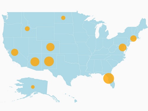
Bubble color can be customized using the ColorMappings property.
Maps provide the following two types of color mapping to bubble marker:
- Equal color mapping
- Range color mapping
Range color mapping
It is used to differentiate the bubble fill based on its under-bound value and color ranges.
The From and To properties are used to define the color range and color for the range that can be specified using the Color property.
<maps:ShapeFileLayer.BubbleMarkerSettings>
    <maps:BubbleMarkerSetting  ValuePath="index" ColorValuePath="index" >
        <maps:BubbleMarkerSetting.ColorMappings>
            <maps:RangeColorMapping Color="#2E769F" From="0" To="15" />
            <maps:RangeColorMapping Color="#D84444" To="30" From="15" />
            <maps:RangeColorMapping Color="#816F28" To="45" From="30" />
            <maps:RangeColorMapping Color="#7F38A0" To="50" From="45" />
        </maps:BubbleMarkerSetting.ColorMappings>
    </maps:BubbleMarkerSetting>
</maps:ShapeFileLayer.BubbleMarkerSettings>
BubbleMarkerSetting bubbleSetting = new BubbleMarkerSetting()
{
ValuePath = "index",
ColorValuePath = "index"
};
bubbleSetting.ColorMappings.Add(new RangeColorMapping() { Color = Color.FromHex("#2E769F"), From = 0, To = 15 });
bubbleSetting.ColorMappings.Add(new RangeColorMapping() { Color = Color.FromHex("#D84444"), From = 15, To = 30 });
bubbleSetting.ColorMappings.Add(new RangeColorMapping() { Color = Color.FromHex("#816F28"), From = 30, To = 45 });
bubbleSetting.ColorMappings.Add(new RangeColorMapping() { Color = Color.FromHex("#7F38A0"), From = 45, To = 50 });
shapeLayer.BubbleMarkerSettings = bubbleSetting;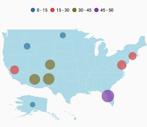
Equal color mapping
It is used to differentiate the bubble fill based on its underlying value and color using the Value and Color properties.
<maps:ShapeFileLayer.BubbleMarkerSettings>
<maps:BubbleMarkerSetting ValuePath="index" ColorValuePath="Type" >
<maps:BubbleMarkerSetting.ColorMappings>
<maps:EqualColorMapping Color="#2E769F" Value="Vegetables" />
<maps:EqualColorMapping Color="#D84444" Value="Rice" />
<maps:EqualColorMapping Color="#816F28" Value="Wheat" />
<maps:EqualColorMapping Color="#7F38A0" Value="Grains" />
</maps:BubbleMarkerSetting.ColorMappings>
</maps:BubbleMarkerSetting>
</maps:ShapeFileLayer.BubbleMarkerSettings>BubbleMarkerSetting bubbleSetting = new BubbleMarkerSetting()
{
ValuePath = "index",
ColorValuePath = "Type"
};
bubbleSetting.ColorMappings.Add(new EqualColorMapping() { Color = Color.FromHex("#2E769F"), Value = "Vegetables" });
bubbleSetting.ColorMappings.Add(new EqualColorMapping() { Color = Color.FromHex("#D84444"), Value = "Rice" });
bubbleSetting.ColorMappings.Add(new EqualColorMapping() { Color = Color.FromHex("#816F28"), Value = "Wheat" });
bubbleSetting.ColorMappings.Add(new EqualColorMapping() { Color = Color.FromHex("#7F38A0"), Value = "Grains" });
shapeLayer.BubbleMarkerSettings = bubbleSetting;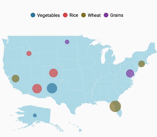
Customizing bubble size
The size of the bubbles depends on the data bound to the ValuePath. The maximum and minimum sizes of the bubbles can be customized using MaxSize and MinSize properties.
IMPORTANT
The
ShowMapItemsshould be enabled to display label on bubble marker.
<maps:ShapeFileLayer.BubbleMarkerSettings>
<maps:BubbleMarkerSetting
ShowBubbles="True"
ValuePath="Electors"
Fill="Orange"
MaxSize="25"
MinSize="20"
Opacity="0.8" />
</maps:ShapeFileLayer.BubbleMarkerSettings>BubbleMarkerSetting bubbleSetting = new BubbleMarkerSetting()
{
ShowBubbles = true,
ValuePath = "Electors",
Fill = Color.Orange,
Opacity = 0.8,
MinSize = 20,
MaxSize = 25
};
shapeLayer.BubbleMarkerSettings = bubbleSetting;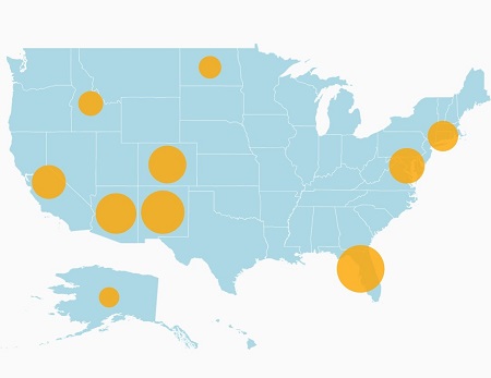
The following code sample demonstrates how to add bubbles to maps and customize them
<maps:SfMaps>
<maps:SfMaps.BindingContext>
<local:ViewModel> </local:ViewModel>
</maps:SfMaps.BindingContext>
<maps:SfMaps.Layers>
<maps:ShapeFileLayer
x:Name="shapeLayer"
Uri="usa_state.shp"
ShapeIDPath="Name"
ShapeIDTableField="STATE_NAME"
ShowMapItems="True"
ItemsSource="{Binding DataSource}">
<maps:ShapeFileLayer.BubbleMarkerSettings>
<maps:BubbleMarkerSetting ValuePath="index" ColorValuePath="index" >
<maps:BubbleMarkerSetting.ColorMappings>
<maps:RangeColorMapping Color="#2E769F" From="0" To="15" />
<maps:RangeColorMapping Color="#D84444" To="30" From="15" />
<maps:RangeColorMapping Color="#816F28" To="45" From="30" />
<maps:RangeColorMapping Color="#7F38A0" To="50" From="45" />
</maps:BubbleMarkerSetting.ColorMappings>
</maps:BubbleMarkerSetting>
</maps:ShapeFileLayer.BubbleMarkerSettings>
<maps:ShapeFileLayer.ShapeSettings>
<maps:ShapeSetting ShapeFill="LightBlue"/>
</maps:ShapeFileLayer.ShapeSettings>
<maps:ShapeFileLayer.LegendSettings>
<maps:MapLegendSetting LegendType="Bubbles" ShowLegend="True"></maps:MapLegendSetting>
</maps:ShapeFileLayer.LegendSettings>
</maps:ShapeFileLayer>
</maps:SfMaps.Layers>
</maps:SfMaps>SfMaps map = new SfMaps()
{
BackgroundColor = Color.White,
};
ShapeFileLayer shapeLayer = new ShapeFileLayer()
{
Uri = "usa_state.shp",
ItemsSource = new ViewModel().DataSource,
ShapeIDTableField = "STATE_NAME",
ShapeIDPath = "Name",
ShowMapItems = true
};
BubbleMarkerSetting bubbleSetting = new BubbleMarkerSetting()
{
    ValuePath = "index",
    ColorValuePath = "index"
};

bubbleSetting.ColorMappings.Add(new RangeColorMapping() { Color = Color.FromHex("#2E769F"), From = 0, To = 15 });
bubbleSetting.ColorMappings.Add(new RangeColorMapping() { Color = Color.FromHex("#D84444"), From = 15, To = 30 });
bubbleSetting.ColorMappings.Add(new RangeColorMapping() { Color = Color.FromHex("#816F28"), From = 30, To = 45 });
bubbleSetting.ColorMappings.Add(new RangeColorMapping() { Color = Color.FromHex("#7F38A0"), From = 45, To = 50 });

shapeLayer.BubbleMarkerSettings = bubbleSetting;
ShapeSetting shapeSetting = new ShapeSetting()
{
ShapeFill = Color.LightBlue
};
shapeLayer.ShapeSettings = shapeSetting;
MapLegendSetting legendSetting = new MapLegendSetting()
{
ShowLegend = true,
LegendType = LegendType.Bubbles
};
shapeLayer.LegendSettings = legendSetting;
map.Layers.Add(shapeLayer);[Model]
public class AgricultureData
{
public AgricultureData(string name, string type, int count)
{
Name = name;
Type = type;
index = count;
}
public string Name
{
get;
set;
}
public string Type
{
get;
set;
}
public int index
{
get;
set;
}
}[ViewModel]
public class ViewModel
{
public ViewModel()
{
DataSource = new ObservableCollection<AgricultureData>();
DataSource.Add(new AgricultureData("Alaska", "Vegetables", 0));
DataSource.Add(new AgricultureData("Arizona", "Rice", 36));
DataSource.Add(new AgricultureData("California", "Wheat", 24));
DataSource.Add(new AgricultureData("Colorado", "Rice", 31));
DataSource.Add(new AgricultureData("North Dakota", "Grains", 4));
DataSource.Add(new AgricultureData("Connecticut", "Wheat", 18));
DataSource.Add(new AgricultureData("District of Columbia", "Grains", 27));
DataSource.Add(new AgricultureData("Florida", "Wheat", 48));
DataSource.Add(new AgricultureData("New Mexico", "Vegetables", 41));
DataSource.Add(new AgricultureData("Idaho", "Rice", 8));
}
public ObservableCollection<AgricultureData> DataSource { get; set; }
}
Showing label on bubble marker.
The ShowMapItems property determines whether the label should be displayed on the bubble marker or not. Set the ShapeValuePath property to get the labels.
NOTE
The default value of
ShowMapItemsproperty is true
<maps:SfMaps>
    <maps:SfMaps.BindingContext>
        <local:ViewModel> </local:ViewModel>
    </maps:SfMaps.BindingContext>
    <maps:SfMaps.Layers>
        <maps:ShapeFileLayer x:Name="shapeLayer" Uri="usa_state.shp" ShapeIDPath="Name" ShapeIDTableField="STATE_NAME" ShowMapItems="True"  ItemsSource="{Binding DataSource}">
            <maps:ShapeFileLayer.BubbleMarkerSettings>
                <maps:BubbleMarkerSetting ValuePath="index" ColorValuePath="index"  MinSize="20" MaxSize="30">
                    <maps:BubbleMarkerSetting.ColorMappings>
                        <maps:RangeColorMapping Color="#2E769F" From="0" To="15" />
                        <maps:RangeColorMapping Color="#D84444" To="30" From="15" />
                        <maps:RangeColorMapping Color="#816F28" To="45" From="30" />
                        <maps:RangeColorMapping Color="#7F38A0" To="50" From="45" />
                    </maps:BubbleMarkerSetting.ColorMappings>
                </maps:BubbleMarkerSetting>
            </maps:ShapeFileLayer.BubbleMarkerSettings>
            <maps:ShapeFileLayer.ShapeSettings>
                <maps:ShapeSetting ShapeFill="LightBlue" ShapeValuePath="index"/>
            </maps:ShapeFileLayer.ShapeSettings>
        </maps:ShapeFileLayer>
    </maps:SfMaps.Layers>
</maps:SfMaps>
SfMaps map = new SfMaps()
{
BackgroundColor = Color.White,
};
ShapeFileLayer shapeLayer = new ShapeFileLayer()
{
Uri = "usa_state.shp",
ItemsSource = new ViewModel().DataSource,
ShapeIDTableField = "STATE_NAME",
ShapeIDPath = "Name",
ShowMapItems = true
};
BubbleMarkerSetting bubbleSetting = new BubbleMarkerSetting()
{
ValuePath = "index",
ColorValuePath = "index",
MinSize = 20,
MaxSize = 30
};
bubbleSetting.ColorMappings.Add(new RangeColorMapping() { Color = Color.FromHex("#2E769F"), From = 0, To = 15 });
bubbleSetting.ColorMappings.Add(new RangeColorMapping() { Color = Color.FromHex("#D84444"), From = 15, To = 30 });
bubbleSetting.ColorMappings.Add(new RangeColorMapping() { Color = Color.FromHex("#816F28"), From = 30, To = 45 });
bubbleSetting.ColorMappings.Add(new RangeColorMapping() { Color = Color.FromHex("#7F38A0"), From = 45, To = 50 });
shapeLayer.BubbleMarkerSettings = bubbleSetting;
ShapeSetting shapeSetting = new ShapeSetting()
{
ShapeFill = Color.LightBlue,
ShapeValuePath = "index"
};
shapeLayer.ShapeSettings = shapeSetting;
shapeLayer.LegendSettings = legendSetting;
map.Layers.Add(shapeLayer);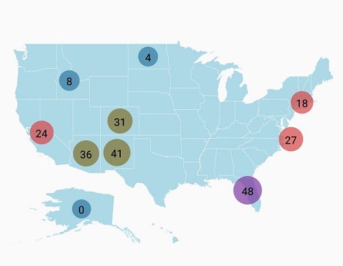
NOTE
You can also explore our Xamarin.Forms Maps example to knows the functionalities of each feature.
See also
How to group the markers based on zoom level in the imagery layer of the SfMaps
How to show the bubble markers in the specific latitude and longitude in SfMaps