Tooltip in Xamarin.Forms Maps (SfMaps)
8 May 202624 minutes to read
Tooltip provides additional information about the shapes in the maps. To enable tooltip, set the ShowTooltip property to true, and set the ValuePath property of tooltip.
Tooltip is displayed by tapping the following elements:
• Shapes
• Bubbles
• Markers
The following code sample shows how to enable tooltip by tapping the shapes.
<maps:SfMaps>
  <maps:SfMaps.Layers >
    <maps:ShapeFileLayer Uri="usa_state.shp" ShapeIDPath="State" ShapeIDTableField="STATE_NAME"                                ItemsSource="{Binding Data}">
    <maps:ShapeFileLayer.TooltipSettings>
        <maps:TooltipSetting ShowTooltip="True" ValuePath="Candidate"/>
    </maps:ShapeFileLayer.TooltipSettings>
    </maps:ShapeFileLayer>
  </maps:SfMaps.Layers>
</maps:SfMaps>
SfMaps sfMaps = new SfMaps();
ShapeFileLayer shapeFileLayer = new ShapeFileLayer();
shapeFileLayer.Uri = "usa_state.shp";
ViewModel model = new ViewModel();
shapeFileLayer.ItemsSource = model.Data;
shapeFileLayer.ShapeIDTableField = "STATE_NAME";
shapeFileLayer.ShapeIDPath = "State";
shapeFileLayer.TooltipSettings.ShowTooltip = true;
shapeFileLayer.TooltipSettings.ValuePath = "Candidate";
sfMaps.Layers.Add(shapeFileLayer);
Content = sfMaps;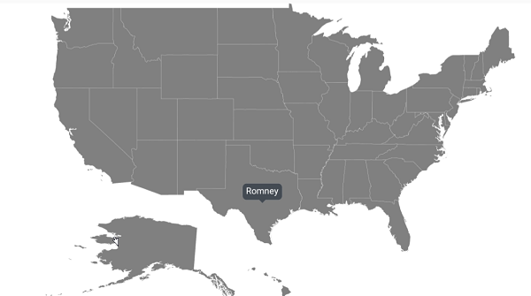
Tooltip customization
The appearance of the tooltip can be customized using the following properties:
-
TextColor: Customizes the text color of tooltip. -
BackgroundColor: Customizes the background color of tooltip. -
StrokeColor: Customizes the stroke color of tooltip. -
StrokeWidth: Customizes the stroke width of tooltip. -
Duration: Specifies the duration of tooltip to be displayed. -
Margin: Sets the margin for tooltip.
The following code sample shows all the above customizations.
<maps:SfMaps>
  <maps:SfMaps.Layers >
    <maps:ShapeFileLayer Uri="usa_state.shp" ShapeIDPath="State" ShapeIDTableField="STATE_NAME"                                ItemsSource="{Binding Data}">
    <maps:ShapeFileLayer.TooltipSettings>
       <maps:TooltipSetting  ShowTooltip="True" ValuePath="Candidate" TextColor="White" Margin="10"                              BackgroundColor="Green"  StrokeColor="Black" StrokeWidth="2"                                        Duration="2000"/>
    </maps:ShapeFileLayer.TooltipSettings>
    </maps:ShapeFileLayer>
  </maps:SfMaps.Layers>
</maps:SfMaps>
SfMaps sfMaps = new SfMaps();
ShapeFileLayer shapeFileLayer = new ShapeFileLayer();
shapeFileLayer.Uri = "usa_state.shp";
ViewModel model = new ViewModel();
shapeFileLayer.ItemsSource = model.Data;
shapeFileLayer.ShapeIDTableField = "STATE_NAME";
shapeFileLayer.ShapeIDPath = "State";
shapeFileLayer.TooltipSettings.ShowTooltip = true;
shapeFileLayer.TooltipSettings.ValuePath = "Candidate";
shapeFileLayer.TooltipSettings.TextColor = Color.White;
shapeFileLayer.TooltipSettings.BackgroundColor = Color.Green;
shapeFileLayer.TooltipSettings.StrokeColor = Color.Black;
shapeFileLayer.TooltipSettings.StrokeWidth = 2;
shapeFileLayer.TooltipSettings.Margin = 10;
shapeFileLayer.TooltipSettings.Duration = 2000;
sfMaps.Layers.Add(shapeFileLayer);
Content = sfMaps;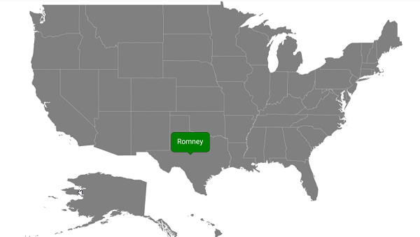
Tooltip font customization
The font can be customized using the FontSize, FontAttributes, and FontFamily properties of tooltip.
<maps:SfMaps>
        <maps:SfMaps.Layers >
            <maps:ShapeFileLayer Uri="usa_state.shp" ShapeIDPath="State" ShapeIDTableField="STATE_NAME" ItemsSource="{Binding Data}">
                <maps:ShapeFileLayer.TooltipSettings>
                    <maps:TooltipSetting  ShowTooltip="True" ValuePath="Candidate" FontSize="15" FontAttributes="Bold">
                        <maps:TooltipSetting.FontFamily>
                            <OnPlatform x:TypeArguments="x:String" iOS="Chalkduster" Android="monospace" WinPhone="Chiller" />
                        </maps:TooltipSetting.FontFamily>
                    </maps:TooltipSetting>
                </maps:ShapeFileLayer.TooltipSettings>
            </maps:ShapeFileLayer>
        </maps:SfMaps.Layers>
</maps:SfMaps>
SfMaps sfMaps = new SfMaps();
ShapeFileLayer shapeFileLayer = new ShapeFileLayer();
shapeFileLayer.Uri = "usa_state.shp";
ViewModel model = new ViewModel();
shapeFileLayer.ItemsSource = model.Data;
shapeFileLayer.ShapeIDTableField = "STATE_NAME";
shapeFileLayer.ShapeIDPath = "State";
shapeFileLayer.TooltipSettings.ShowTooltip = true;
shapeFileLayer.TooltipSettings.ValuePath = "Candidate";
shapeFileLayer.TooltipSettings.FontSize = 15;
shapeFileLayer.TooltipSettings.FontAttributes = FontAttributes.Bold;
shapeFileLayer.TooltipSettings.FontFamily = Device.RuntimePlatform == Device.iOS ? "Chalkduster" : Device.RuntimePlatform == Device.Android ? "monospace" : "Chiller";
sfMaps.Layers.Add(shapeFileLayer);
Content = sfMaps;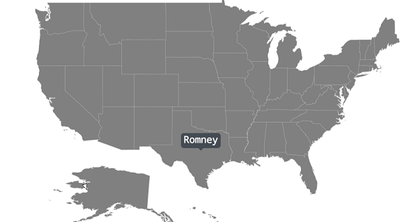
Custom template for tooltip
The maps control provides options to design your own template for tooltip using the TooltipTemplate property.
<maps:SfMaps Margin="20" BackgroundColor="White">
        <maps:SfMaps.Layers >
            <maps:ShapeFileLayer Uri="usa_state.shp" ShapeIDPath="State" ShapeIDTableField="STATE_NAME" ItemsSource="{Binding Data}">
                <maps:ShapeFileLayer.ShapeSettings>
                    <maps:ShapeSetting ShapeValuePath="Candidate" ShapeColorValuePath="Candidate" >
                        <maps:ShapeSetting.ColorMappings>
                            <maps:EqualColorMapping Color="#D84444" Value = "Romney"/>
                            <maps:EqualColorMapping Color="#316DB5" Value="Obama"/>
                        </maps:ShapeSetting.ColorMappings>
                    </maps:ShapeSetting>
                </maps:ShapeFileLayer.ShapeSettings>
                <maps:ShapeFileLayer.TooltipSettings>
                    <maps:TooltipSetting  ShowTooltip="True" ValuePath="State" Duration="2000">
                        <maps:TooltipSetting.TooltipTemplate>
                            <DataTemplate>
                                <StackLayout>
                                    <Label Text="{Binding State}" HorizontalTextAlignment="Center" VerticalTextAlignment="Center" TextColor="#FFFFFF" FontAttributes="Bold" FontFamily="Helvetica" Margin="0" FontSize="12" Grid.Row="0" />
                                    <BoxView Color="#888C91" HeightRequest="1" VerticalOptions="FillAndExpand" HorizontalOptions="FillAndExpand" />
                                    <Label Text="{Binding Candidate}" VerticalTextAlignment="Center" HorizontalOptions="Center" TextColor="#FFFFFF" FontAttributes="Bold" FontFamily="Helvetica" FontSize="12" />
                                </StackLayout>
                            </DataTemplate>
                        </maps:TooltipSetting.TooltipTemplate>
                    </maps:TooltipSetting>
                </maps:ShapeFileLayer.TooltipSettings>
            </maps:ShapeFileLayer>
        </maps:SfMaps.Layers>
</maps:SfMaps>
SfMaps sfMaps = new SfMaps();
ShapeFileLayer shapeFileLayer = new ShapeFileLayer();
shapeFileLayer.Uri = "usa_state.shp";
ViewModel model = new ViewModel();
shapeFileLayer.ItemsSource = model.Data;
shapeFileLayer.ShapeIDTableField = "STATE_NAME";
shapeFileLayer.ShapeIDPath = "State";
EqualColorMapping colorMapping = new EqualColorMapping();
colorMapping.Color = Color.FromHex("#D84444");
colorMapping.Value = "Romney";
EqualColorMapping colorMapping1 = new EqualColorMapping();
colorMapping1.Color = Color.FromHex("#316DB5");
colorMapping1.Value = "Obama";
ShapeSetting shapeSetting = new ShapeSetting();
shapeSetting.ShapeValuePath = "Candidate";
shapeSetting.ShapeColorValuePath = "Candidate";
shapeSetting.ColorMappings.Add(colorMapping);
shapeSetting.ColorMappings.Add(colorMapping1);
shapeFileLayer.ShapeSettings = shapeSetting;
shapeFileLayer.TooltipSettings.ShowTooltip = true;
shapeFileLayer.TooltipSettings.ValuePath = "State";
DataTemplate template = new DataTemplate(() =>
{
StackLayout categoryLayout = new StackLayout();
Label category = new Label();
category.HorizontalTextAlignment = TextAlignment.Center;
category.VerticalTextAlignment = TextAlignment.Center;
category.TextColor = Color.FromHex("#FFFFFF");
category.FontAttributes = FontAttributes.Bold;
category.FontFamily = "Helvetica";
category.Margin = 0;
category.FontSize = 12;
category.SetBinding(Label.TextProperty, "State");
categoryLayout.Children.Add(category);
BoxView boxView = new BoxView();
boxView.Color = Color.FromHex("#888C91");
boxView.HeightRequest = 1;
boxView.VerticalOptions = LayoutOptions.FillAndExpand;
boxView.HorizontalOptions = LayoutOptions.FillAndExpand;
categoryLayout.Children.Add(boxView);
Label category1 = new Label();
category1.HorizontalTextAlignment = TextAlignment.Center;
category1.VerticalTextAlignment = TextAlignment.Center;
category1.TextColor = Color.FromHex("#FFFFFF");
category1.FontAttributes = FontAttributes.Bold;
category1.FontFamily = "Helvetica";
category1.Margin = 0;
category1.FontSize = 12;
category1.SetBinding(Label.TextProperty, "Candidate");
categoryLayout.Children.Add(category1);
return categoryLayout;
});
shapeFileLayer.TooltipSettings.TooltipTemplate = template;
sfMaps.Layers.Add(shapeFileLayer);
Content = sfMaps;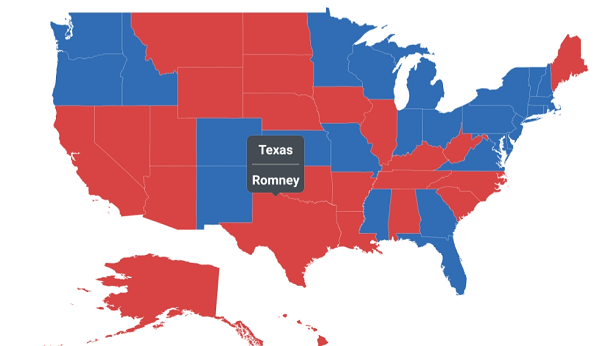
Setting animation for tooltip
You can enable or disable the animation of tooltip using the EnableAnimation property.
<maps:ShapeFileLayer.TooltipSettings>
        <maps:TooltipSetting  ShowTooltip="True" ValuePath="State"  EnableAnimation="False"/>
</maps:ShapeFileLayer.TooltipSettings>shapeFileLayer.TooltipSettings.ShowTooltip = true;
shapeFileLayer.TooltipSettings.ValuePath = "State";
shapeFileLayer.TooltipSettings.EnableAnimation = false;
sfMaps.Layers.Add(shapeFileLayer);Setting pointer length for tooltip
You can customize the pointer length of the tooltip using the PointerLength property.
<maps:SfMaps>
            <maps:SfMaps.Layers >
                <maps:ShapeFileLayer Uri="usa_state.shp" ShapeIDPath="State" ShapeIDTableField="STATE_NAME" ItemsSource="{Binding Data}">
                    <maps:ShapeFileLayer.TooltipSettings>
                        <maps:TooltipSetting  ShowTooltip="True" ValuePath="Candidate" PointerLength="18"/>
                    </maps:ShapeFileLayer.TooltipSettings>
                </maps:ShapeFileLayer>
            </maps:SfMaps.Layers>
  </maps:SfMaps>
SfMaps sfMaps = new SfMaps();
ShapeFileLayer shapeFileLayer = new ShapeFileLayer();
shapeFileLayer.Uri = "usa_state.shp";
ViewModel model = new ViewModel();
shapeFileLayer.ItemsSource = model.Data;
shapeFileLayer.ShapeIDTableField = "STATE_NAME";
shapeFileLayer.ShapeIDPath = "State";
shapeFileLayer.TooltipSettings.ShowTooltip = true;
shapeFileLayer.TooltipSettings.ValuePath = "Candidate";
shapeFileLayer.TooltipSettings.PointerLength = 18;
sfMaps.Layers.Add(shapeFileLayer);
Content = sfMaps;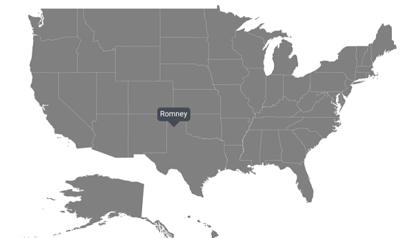
Events
Tooltip opening event
This event occurs whenever you select a shape, bubble, or marker. You will get the Data and TooltipType properties as arguments from TooltipOpeningEventArgs handler, and you can cancel the event for a particular shape using the Cancel property.
<maps:SfMaps  TooltipOpening="SfMaps_TooltipOpening">
            <maps:SfMaps.Layers >
                <maps:ShapeFileLayer Uri="usa_state.shp" ShapeIDPath="State" ShapeIDTableField="STATE_NAME" ItemsSource="{Binding Data}">
                    <maps:ShapeFileLayer.TooltipSettings>
                        <maps:TooltipSetting  ShowTooltip="True" ValuePath="State" />
                    </maps:ShapeFileLayer.TooltipSettings>
                </maps:ShapeFileLayer>
            </maps:SfMaps.Layers>
</maps:SfMaps>
private void SfMaps_TooltipOpening(object sender, TooltipOpeningEventArgs e)
{
if ((e.Data is ElectionData) && (e.Data as ElectionData).State == "Montana")
{
e.Cancel = true;
}
}Tooltip for bubbles
You can get tooltip by tapping the bubbles in the shapes.
<maps:SfMaps>
        <maps:SfMaps.Layers >
            <maps:ShapeFileLayer Uri="usa_state.shp" ShapeIDPath="State" ShapeIDTableField="STATE_NAME" ItemsSource="{Binding Data}">
                <maps:ShapeFileLayer.BubbleMarkerSettings>
                    <maps:BubbleMarkerSetting ValuePath="Electors" ColorValuePath="Electors"  Fill="#7F38A0">
                        <maps:BubbleMarkerSetting.TooltipSettings>
                            <maps:TooltipSetting ShowTooltip="True" ValuePath="Electors"/>
                        </maps:BubbleMarkerSetting.TooltipSettings>
                    </maps:BubbleMarkerSetting>
                </maps:ShapeFileLayer.BubbleMarkerSettings>
                <maps:ShapeFileLayer.ShapeSettings>
                    <maps:ShapeSetting ShapeFill="LightGray"/>
                </maps:ShapeFileLayer.ShapeSettings>
            </maps:ShapeFileLayer>
        </maps:SfMaps.Layers>
</maps:SfMaps>
SfMaps sfMaps = new SfMaps();
ShapeFileLayer shapeFileLayer = new ShapeFileLayer();
shapeFileLayer.Uri = "usa_state.shp";
ViewModel model = new ViewModel();
shapeFileLayer.ItemsSource = model.Data;
shapeFileLayer.ShapeIDTableField = "STATE_NAME";
shapeFileLayer.ShapeIDPath = "State";
BubbleMarkerSetting bubbleMarkerSetting = new BubbleMarkerSetting();
bubbleMarkerSetting.ColorValuePath = "Electors";
bubbleMarkerSetting.ValuePath = "Electors";
bubbleMarkerSetting.Fill = Color.FromHex("#7F38A0");
bubbleMarkerSetting.TooltipSettings.ShowTooltip = true;
bubbleMarkerSetting.TooltipSettings.ValuePath = "Electors";
shapeFileLayer.BubbleMarkerSettings = bubbleMarkerSetting;
ShapeSetting shapeSetting = new ShapeSetting();
shapeSetting.ShapeFill = Color.LightGray;
shapeFileLayer.ShapeSettings = shapeSetting;
sfMaps.Layers.Add(shapeFileLayer);
Content = sfMaps;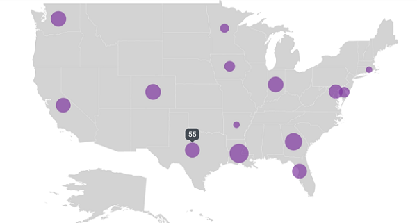
Bubble tooltip customization
To customize the tooltip in the bubbles, refer to this link.
<maps:SfMaps>
        <maps:SfMaps.Layers >
            <maps:ShapeFileLayer Uri="usa_state.shp" ShapeIDPath="State" ShapeIDTableField="STATE_NAME" ItemsSource="{Binding Data}">
                <maps:ShapeFileLayer.BubbleMarkerSettings>
                    <maps:BubbleMarkerSetting ValuePath="Electors" ColorValuePath="Electors"  Fill="#7F38A0">
                        <maps:BubbleMarkerSetting.TooltipSettings>
                            <maps:TooltipSetting ShowTooltip="True" ValuePath="Electors" TextColor="White" Margin="10" BackgroundColor="Violet"  StrokeColor="Black" StrokeWidth="2" Duration="2000"/>
                        </maps:BubbleMarkerSetting.TooltipSettings>
                    </maps:BubbleMarkerSetting>
                </maps:ShapeFileLayer.BubbleMarkerSettings>
                <maps:ShapeFileLayer.ShapeSettings>
                    <maps:ShapeSetting ShapeFill="LightGray"/>
                </maps:ShapeFileLayer.ShapeSettings>
            </maps:ShapeFileLayer>
        </maps:SfMaps.Layers>
</maps:SfMaps>
SfMaps sfMaps = new SfMaps();
ShapeFileLayer shapeFileLayer = new ShapeFileLayer();
shapeFileLayer.Uri = "usa_state.shp";
ViewModel model = new ViewModel();
shapeFileLayer.ItemsSource = model.Data;
shapeFileLayer.ShapeIDTableField = "STATE_NAME";
shapeFileLayer.ShapeIDPath = "State";
BubbleMarkerSetting bubbleMarkerSetting = new BubbleMarkerSetting();
bubbleMarkerSetting.ColorValuePath = "Electors";
bubbleMarkerSetting.ValuePath = "Electors";
bubbleMarkerSetting.Fill = Color.FromHex("#7F38A0");
bubbleMarkerSetting.TooltipSettings.ShowTooltip = true;
bubbleMarkerSetting.TooltipSettings.TextColor = Color.White;
bubbleMarkerSetting.TooltipSettings.BackgroundColor = Color.Violet;
bubbleMarkerSetting.TooltipSettings.StrokeColor = Color.Black;
bubbleMarkerSetting.TooltipSettings.StrokeWidth = 2;
bubbleMarkerSetting.TooltipSettings.Margin = 10;
bubbleMarkerSetting.TooltipSettings.Duration = 2000;
bubbleMarkerSetting.TooltipSettings.ValuePath = "Electors";
shapeFileLayer.BubbleMarkerSettings = bubbleMarkerSetting;
ShapeSetting shapeSetting = new ShapeSetting();
shapeSetting.ShapeFill = Color.LightGray;
shapeFileLayer.ShapeSettings = shapeSetting;
sfMaps.Layers.Add(shapeFileLayer);
Content = sfMaps;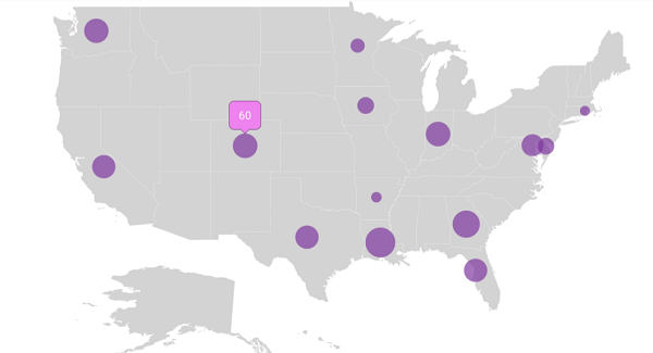
Tooltip for markers
You can get the tooltip by tapping the markers in the shapes and markers in the imagery layer.
Marker tooltip in shape layer
<maps:SfMaps>
        <maps:SfMaps.Layers >
            <maps:ShapeFileLayer Uri="usa_state.shp" ShapeIDPath="State" ShapeIDTableField="STATE_NAME" ItemsSource="{Binding Data}">
                <maps:ShapeFileLayer.Markers>
                    <maps:MapMarker Label="Texas" Latitude="31.267153" Longitude="-97.7430608"/>
                    <maps:MapMarker Label="California" Latitude="37" Longitude="-120"/>
                </maps:ShapeFileLayer.Markers>
                <maps:ShapeFileLayer.MarkerSettings>
                    <maps:MapMarkerSetting>
                        <maps:MapMarkerSetting.TooltipSettings>
                            <maps:TooltipSetting ShowTooltip="True" ValuePath="Label" />
                        </maps:MapMarkerSetting.TooltipSettings>
                    </maps:MapMarkerSetting>
                </maps:ShapeFileLayer.MarkerSettings>
            </maps:ShapeFileLayer>
        </maps:SfMaps.Layers>
</maps:SfMaps>
SfMaps sfMaps = new SfMaps();
ShapeFileLayer shapeFileLayer = new ShapeFileLayer();
shapeFileLayer.Uri = "usa_state.shp";
ViewModel model = new ViewModel();
shapeFileLayer.ItemsSource = model.Data;
shapeFileLayer.ShapeIDTableField = "STATE_NAME";
shapeFileLayer.ShapeIDPath = "State";
MapMarker mapMarker = new MapMarker();
mapMarker.Label = "Texas";
mapMarker.Latitude = "31.267153";
mapMarker.Longitude = "-97.7430608";
shapeFileLayer.Markers.Add(mapMarker);
MapMarker mapMarker1 = new MapMarker();
mapMarker1.Label = "California";
mapMarker1.Latitude = "37";
mapMarker1.Longitude = "-120";
shapeFileLayer.Markers.Add(mapMarker1);
MapMarkerSetting mapMarkerSetting = new MapMarkerSetting();
mapMarkerSetting.TooltipSettings.ShowTooltip = true;
mapMarkerSetting.TooltipSettings.ValuePath = "Label";
mapMarkerSetting.TooltipSettings.Duration = 2000;
shapeFileLayer.MarkerSettings = mapMarkerSetting;
sfMaps.Layers.Add(shapeFileLayer);
Content = sfMaps;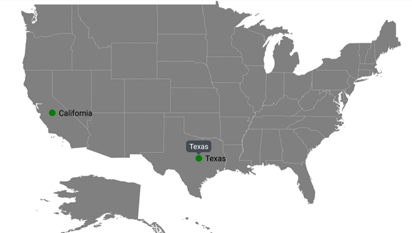
Marker tooltip in imagery layer
<maps:SfMaps BackgroundColor="White" Margin="10">
        <maps:SfMaps.Layers >
            <maps:ImageryLayer>
                <maps:ImageryLayer.Markers>
                    <maps:MapMarker Label="India" Latitude="20.593683" Longitude="78.962883" />
                </maps:ImageryLayer.Markers>
                <maps:ImageryLayer.MarkerSettings>
                    <maps:MapMarkerSetting MarkerIcon="Image" ImageSource="pin.png" IconSize="15">
                        <maps:MapMarkerSetting.TooltipSettings>
                            <maps:TooltipSetting ShowTooltip="True" ValuePath="Label" TextColor="White"
                                                 Margin="10" BackgroundColor="Navy"
                                                 StrokeColor="Black" StrokeWidth="2" />
                        </maps:MapMarkerSetting.TooltipSettings>
                    </maps:MapMarkerSetting>
                </maps:ImageryLayer.MarkerSettings>
            </maps:ImageryLayer>
        </maps:SfMaps.Layers>
</maps:SfMaps>
SfMaps sfMaps = new SfMaps();
ImageryLayer imageryLayer = new ImageryLayer();
MapMarker mapMarker = new MapMarker();
mapMarker.Label = "India";
mapMarker.Latitude = "20.593683";
mapMarker.Longitude = "78.962883";
imageryLayer.Markers.Add(mapMarker);
MapMarkerSetting mapMarkerSetting = new MapMarkerSetting();
mapMarkerSetting.MarkerIcon = MapMarkerIcon.Image;
mapMarkerSetting.ImageSource = "pin.png";
mapMarkerSetting.IconSize = 15;
mapMarkerSetting.TooltipSettings.ShowTooltip = true;
mapMarkerSetting.TooltipSettings.ValuePath = "Label";
mapMarkerSetting.TooltipSettings.TextColor = Color.White;
mapMarkerSetting.TooltipSettings.BackgroundColor = Color.Navy;
mapMarkerSetting.TooltipSettings.StrokeColor = Color.Black;
mapMarkerSetting.TooltipSettings.StrokeWidth = 2;
mapMarkerSetting.TooltipSettings.Margin = 10;
imageryLayer.MarkerSettings = mapMarkerSetting;
sfMaps.Layers.Add(imageryLayer);
Content = sfMaps;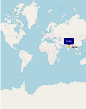
Marker tooltip customization
To customize the tooltip in the marker, refer to this link.
<maps:SfMaps BackgroundColor="White" Margin="10">
        <maps:SfMaps.Layers >
            <maps:ShapeFileLayer Uri="usa_state.shp" ShapeIDPath="State" ShapeIDTableField="STATE_NAME" ItemsSource="{Binding Data}">
                <maps:ShapeFileLayer.Markers>
                    <maps:MapMarker Label="Texas" Latitude="31.267153" Longitude="-97.7430608"/>
                    <maps:MapMarker Label="California" Latitude="37" Longitude="-120"/>
                </maps:ShapeFileLayer.Markers>
                <maps:ShapeFileLayer.MarkerSettings>
                    <maps:MapMarkerSetting>
                        <maps:MapMarkerSetting.TooltipSettings>
                            <maps:TooltipSetting ShowTooltip="True" ValuePath="Label" TextColor="White"
                                                 Margin="10" BackgroundColor="Blue"
                                                 StrokeColor="Black" StrokeWidth="2" Duration="2000"/>
                        </maps:MapMarkerSetting.TooltipSettings>
                    </maps:MapMarkerSetting>
                </maps:ShapeFileLayer.MarkerSettings>
            </maps:ShapeFileLayer>
        </maps:SfMaps.Layers>
</maps:SfMaps>
SfMaps sfMaps = new SfMaps();
ShapeFileLayer shapeFileLayer = new ShapeFileLayer();
shapeFileLayer.Uri = "usa_state.shp";
ViewModel model = new ViewModel();
shapeFileLayer.ItemsSource = model.Data;
shapeFileLayer.ShapeIDTableField = "STATE_NAME";
shapeFileLayer.ShapeIDPath = "State";
MapMarker mapMarker = new MapMarker();
mapMarker.Label = "Texas";
mapMarker.Latitude = "31.267153";
mapMarker.Longitude = "-97.7430608";
shapeFileLayer.Markers.Add(mapMarker);
MapMarker mapMarker1 = new MapMarker();
mapMarker1.Label = "California";
mapMarker1.Latitude = "37";
mapMarker1.Longitude = "-120";
shapeFileLayer.Markers.Add(mapMarker1);
MapMarkerSetting mapMarkerSetting = new MapMarkerSetting();
mapMarkerSetting.TooltipSettings.ShowTooltip = true;
mapMarkerSetting.TooltipSettings.ValuePath = "Label";
mapMarkerSetting.TooltipSettings.TextColor = Color.White;
mapMarkerSetting.TooltipSettings.BackgroundColor = Color.Blue;
mapMarkerSetting.TooltipSettings.StrokeColor = Color.Black;
mapMarkerSetting.TooltipSettings.StrokeWidth = 2;
mapMarkerSetting.TooltipSettings.Margin = 10;
mapMarkerSetting.TooltipSettings.Duration = 2000;
shapeFileLayer.MarkerSettings = mapMarkerSetting;
sfMaps.Layers.Add(shapeFileLayer);
Content = sfMaps;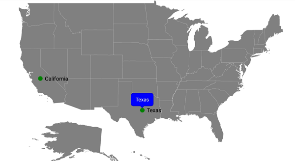
NOTE
You can refer to our Xamarin Maps feature tour page for its groundbreaking feature representations.
You can also explore our Xamarin.Forms Maps example to knows the functionalities of each feature.