User Interaction
20 Jun 201820 minutes to read
Options like zooming, panning, and map selection enables the effective interaction on Map elements.
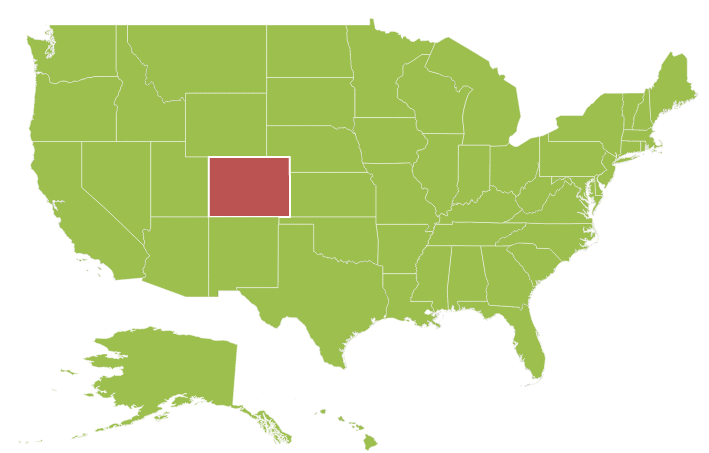
Map Selection
Each shape in the Map can be selected and deselected during interaction with the shapes.
The selectionColor property is used to get or set the selected shape color. The selectionStroke and selectionStrokeWidth properties are used to customize the selected shape border.
You can select the shape by tapping the shape. The Single selection is enabled by the enableSelection property of shape layer. When enableSelection is set to false, the shapes cannot be selected.
jQuery(function($) {
            $("#mapContainer").ejMap({
                layers: [
                    {
                        shapeData: usMap,
                        shapeSettings: {
                            fill: "#9CBF4E",
                            strokeThickness: "0.5",
                            stroke: "White",
                            selectionStrokeWidth: 2,
                            selectionStroke:"white",
                            selectionColor: "#BC5353"
                        },
                        enableSelection: true
                    }
                ]
            });
        });
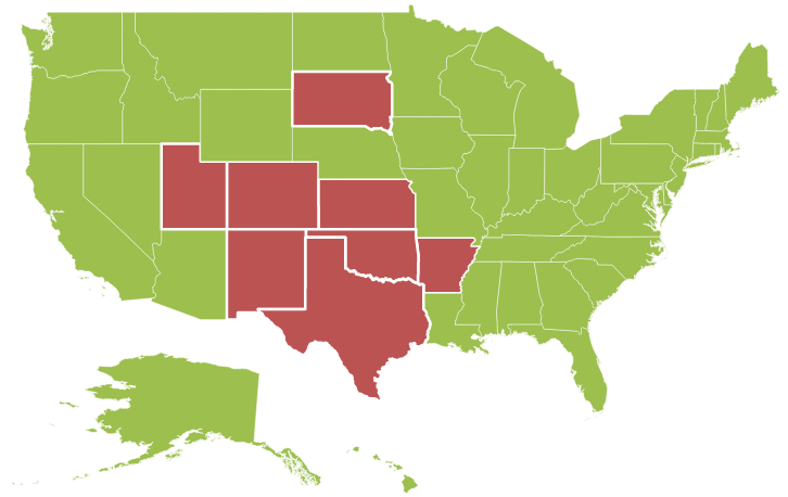
MultiSelection
This feature enables you to select multiple Map shapes on mouse taps accompanied by the “Control” key press. To enable this feature, set the selectionMode property as “multiple” along with the enableSelection property.
jQuery(function($) {
            $("#mapContainer").ejMap({
                layers: [
                    {
                        shapeData: usMap,
                        // ...
                        enableSelection: true,
                        selectionMode: "multiple",
                        // ..
                    }
                ]
            });
        });
Dragging On Selection
This feature enables you to select the shapes by dragging over the shapes. While dragging over the shapes, a rectangle is generated and the shapes that comes within the rectangle is selected.
You can enable this feature by setting the draggingOnSelection property in the layers to true.
jQuery(function($) {
            $("#mapContainer").ejMap({
                layers: [
                    {
                        // ...
                        draggingOnSelection: true
                        // ...
                    }
                ]
            });
        });
Enable Mouse hover
Enables or disables the shape mouse hover.
jQuery(function($) {
            $("#mapContainer").ejMap({
                layers: [
                    {
                        // ...
                        enableMouseHover: true
                        // ...
                    }
                ]
            });
        });
Zooming
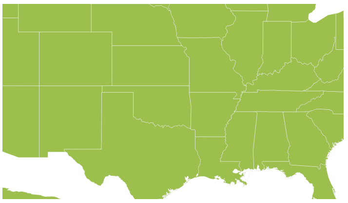
The zooming feature enables you to zoom in and out the Map to show in-depth information. It is controlled by the level property of the Map. When the zoom level of the Map control is increased, the Map is zoomed in. When the zoom level is decreased, then the Map is zoomed out.
Properties
The following properties are related to the zooming feature of the Maps control:
-
level
-
enableZoom
-
minValue
-
maxValue
Level
The level property determines the Map’s scale size when zooming. The default value of level is 1.
NOTE
level cannot be less than 1
EnableZoom
The enableZoom property enables or disables the zooming feature.
MinValue
The minValue property is used to set the minimum zoom level of the Map.
MaxValue
The maxValue property is used to set the maximum zoom level of the Map.
jQuery(function($) {
            $("#mapContainer").ejMap({
                layers: [
                    {
                        shapeData: usMap
                    }
                ],
                zoomSettings:{
                    enableZoom: true,
                    minValue: 1,
                    maxValue: 20,
                    level: 1
                }
            });
        });
Factor
Specifies the zoom factor for map zoom value, you can use factor property.
jQuery(function($) {
            $("#mapContainer").ejMap({
                layers: [
                    {
                        shapeData: usMap
                    }
                ],
                zoomSettings:{
                    enableZoom: true,
                    factor: 1
                }
            });
        });
Additional Options to Zoom the Map
Maps can be zoomed by using the following options also,
- Zoom method.
- mouse scroll.
- mouse double tap.
- shape selection
- Position
Zoom method
You can zoom the Maps by using zoom method. The zoom method contains parameter zoom value. The Map can be zoomed or scaled based on zoom value parameter.
$("#map").ejMap("zoom", 2);Mouse scroll
You can zoom the Map with mouse events by using mouse scroll. When the mouse is scrolled up, the Map is zoomed in and when the mouse is scrolled down, the Map is zoomed out.
Mouse double tap
When the Map is double-tapped by using mouse, the zoom in operation is performed.
Shape Selection
Map shape is zoomed to the whole Map area on the shape selected. Animation can be applied for that zooming by using the enableAnimation property as true.
You can enable this feature by setting enableZoomOnSelection property value as ‘true’.
When enableZoomOnSelection property is set to true, then zooming by double click is muted.
jQuery(function($) {
            $("#mapContainer").ejMap({
                // ...
                zoomSettings:
                {
                     enableZoomOnSelection: true
                },
                // ...
            });
        });
Positioning
Depending on the latitude and longitude, you can zoom the Map to the exact position. All locations are considered as latitude and longitude values and the exact location is considered as Map coordinates.
The navigateTo is a method that allows you to zoom the Map control to the given location. This method contains three attributes as follows.
| Attribute | Type | Description |
|---|---|---|
| Latitude | Double | Latitude point of the position |
| Longitude | Double | Longitude point of the position |
| level | Double | Zoom level of the map |
<script type="text/javascript">
        function buttonClick() {
            $("#map").ejMap("navigateTo", 13, 80, 5);
        }
    </script>
Panning
The panning feature enables the Map navigation. The enablePan property is used to enable or disable the panning support.
jQuery(function($) {
            $("#mapContainer").ejMap({
                // ...
                enablePan: true
                // ...
            });
        });
Mouse Wheel Zoom
You can zoom the Map with mouse by using mouse wheel. When the mouse is wheeled, the Map is zoomed in.
You can enable this feature by setting enableMouseWheelZoom property value as ‘true’.
jQuery(function($) {
$("#mapContainer").ejMap({
// ...
zoomSettings:
{
enableMouseWheelZoom: true
},
// ...
});
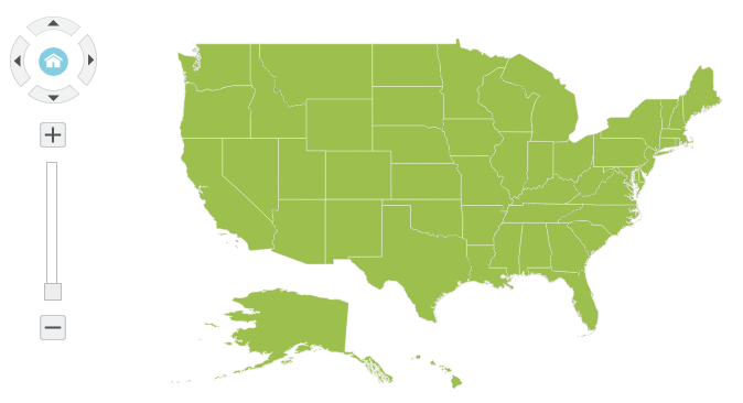
});Navigation Control
Navigation control is built-in with Maps control. With Navigation control, Maps can be panned in any direction and zoomed. It is possible to show or hide the NavigationControl by enableNavigation property.
jQuery(function($) {
            $("#mapContainer").ejMap({
                // ...
                navigationControl:{enableNavigation:true},
                // ...
            });
        });
Positions
The Navigation control can be positioned in two ways.
- Absolute Position
- Dock Position
Absolute Position
Based on the margin values of X and Y-axes, the navigation control can be positioned with the help of the x and y properties available in absolutePosition. For positioning the navigation control based on margins corresponding to a Map, dockPosition value is set as ‘none’.
Dock Position
The navigation control can be positioned in the following locations within the container.
- topLeft
- topCenter
- topRight
- centerLeft
- center
- centerRight
- bottomLeft
- bottomRight
- bottomCenter
- bottomRight
- none
You can set this option by using dockPosition property in navigationControl.
jQuery(function($) {
            $("#mapContainer").ejMap({
                // ...
                navigationControl:{enableNavigation:true,orientation:'vertical',absolutePosition:{x:5,y:16},dockPosition:'none'},
                // ...
            });
        });
Orientation
Set the orientation value for navigation control.
| Name | Description |
|---|---|
| horizontal | specifies the horizontal position |
| vertical | specifies the vertical position |
//To set orientation value during initialization
   $("#container").ejMap(navigationControl:{orientation:'vertical'});
Content
Specifies the navigation control template for map, you can use content property.
//To set navigation control template for map during initialization
   $("#container").ejMap(navigationControl:{content:null});
Animation
Animation is enabled or disabled using enable animation property.
$("#Map").ejMap({
        enableAnimation: true,
    });
Enable Layer Change Animation
Enables or Disables the animation for layer change in map, you can use enableLayerChangeAnimation property and the default value is false.
//To set enableLayerChangeAnimation API value during initialization
   $("#container").ejMap({enableLayerChangeAnimation:true});
Responsiveness during browser resize
Map is made responsive when resizing the browser by using isResponsive property.
$("#Map").ejMap({
        isResponsive: true,
});
Responsiveness of the map is controlled by using enableResize property.
$("#Map").ejMap({
        enableResize: true,
});
Localization
Name of the culture based on which map should be localized. Labels are localized with respect to the culture name.String type properties like template text are not localized automatically. Provide localized text as value to string type properties.
$("#Map").ejMap({
        locale: "en-US",
});