How can I help you?
Data Labels
3 Sep 20206 minutes to read
Data labels are used to display the values of the shapes.
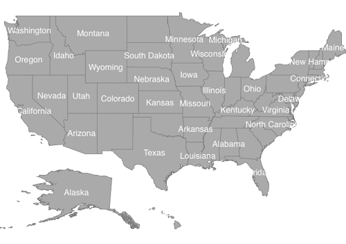
Adding data labels
ShowMapItems property is a boolean property that displays or hides the data labels in shapes. You must set the ValuePath property to get the data labels which is bound for each shape.
SFMap map = new SFMap();

SFShapeFileLayer layer = new SFShapeFileLayer();

layer.Uri = (NSString)NSBundle.MainBundle.PathForResource("usa_state", "shp");

layer.ShowMapItems = true;

layer.DataSource = GetDataSource();

layer.ShapeIDTableField = (NSString)"STATE_NAME";

layer.ShapeIDPath = (NSString)"Name";

layer.ShapeSettings.ValuePath = (NSString)"Type";

layer.ShapeSettings.Fill = UIColor.LightGray;

layer.DataLabelSettings.SmartLabelMode = IntersectAction.Hide;

map.Layers.Add(layer);

this.View.AddSubview(map);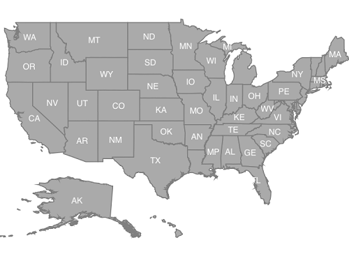
Setting contrast color
Based on the shape background color, contrast color will be applied for the data labels.
SFMap map = new SFMap();

SFShapeFileLayer layer = new SFShapeFileLayer();

layer.Uri = (NSString)NSBundle.MainBundle.PathForResource("usa_state", "shp");

layer.ShowMapItems = true;

layer.DataSource = GetDataSource();

layer.ShapeIDTableField = (NSString)"STATE_NAME";

layer.ShapeIDPath = (NSString)"Name";

layer.ShapeSettings.ValuePath = (NSString)"Type";

layer.ShapeSettings.ColorValuePath = (NSString)"Count";

layer.ShapeSettings.StrokeColor = UIColor.White;

layer.ShapeSettings.StrokeThickness = (nfloat)0.5;

SFRangeColorMapping rangeColorMapping = new SFRangeColorMapping();

rangeColorMapping.From = 0;

rangeColorMapping.To = 25;

rangeColorMapping.Color = UIColor.FromRGB(255, 216, 79);

SFRangeColorMapping rangeColorMapping1 = new SFRangeColorMapping();

rangeColorMapping1.From = 25;

rangeColorMapping1.To = 50;

rangeColorMapping1.Color = UIColor.FromRGB(49, 109, 181);

layer.ShapeSettings.ColorMappings.Add(rangeColorMapping);

layer.ShapeSettings.ColorMappings.Add(rangeColorMapping1);

layer.DataLabelSettings.SmartLabelMode = IntersectAction.Hide;

map.Layers.Add(layer);

this.View.AddSubview(map);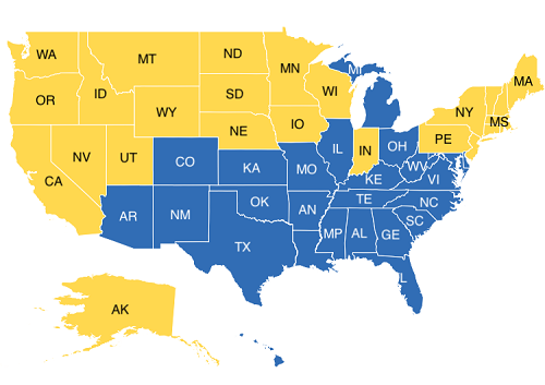
Customizing data labels
Data labels can be customized using the SFDataLabelSetting property in shape file layer. The font, and color can be customized using Font, TextColor properties.
SFMap map = new SFMap();

SFShapeFileLayer layer = new SFShapeFileLayer();

layer.Uri = (NSString)NSBundle.MainBundle.PathForResource("usa_state", "shp");

layer.ShowMapItems = true;

layer.DataSource = GetDataSource();

layer.ShapeIDTableField = (NSString)"STATE_NAME";

layer.ShapeIDPath = (NSString)"Name";

layer.ShapeSettings.ValuePath = (NSString)"Type";

layer.ShapeSettings.ColorValuePath = (NSString)"Count";

layer.ShapeSettings.Fill = UIColor.LightGray;

layer.ShapeSettings.StrokeThickness = (nfloat)0.5;

layer.DataLabelSettings.TextColor = UIColor.Blue;

layer.DataLabelSettings.Font = UIFont.FromName("Chalkduster", 10f);

layer.DataLabelSettings.SmartLabelMode = IntersectAction.Hide;

map.Layers.Add(layer);

this.View.AddSubview(map);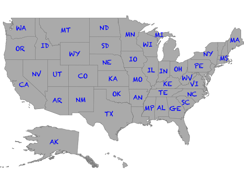
To smartly align data label
SmartLabelMode smartly aligns labels within shape boundaries and avoids label overlap. Labels can be customized using the Hide, Trim and None options.
SFMap map = new SFMap();

SFShapeFileLayer layer = new SFShapeFileLayer();

layer.Uri = (NSString)NSBundle.MainBundle.PathForResource("usa_state", "shp");

layer.ShowMapItems = true;

layer.DataSource = GetDataSource();

layer.ShapeIDTableField = (NSString)"STATE_NAME";

layer.ShapeIDPath = (NSString)"Name";

layer.ShapeSettings.ValuePath = (NSString)"Name";

layer.ShapeSettings.Fill = UIColor.LightGray;

layer.ShapeSettings.StrokeThickness = (nfloat)0.5;

layer.DataLabelSettings.SmartLabelMode = IntersectAction.Trim;

map.Layers.Add(layer);

this.View.AddSubview(map);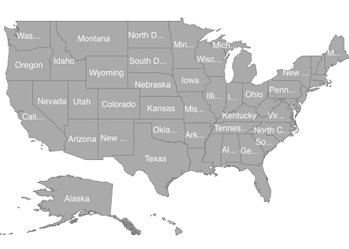
To avoid overlap in data label
IntersectionAction smartly aligns labels which is overlapped with another label. Labels can be customized using the Hide, Trim and None options. First, you should set the SmartLabelMode property as None.
SFMap map = new SFMap();

SFShapeFileLayer layer = new SFShapeFileLayer();

layer.Uri = (NSString)NSBundle.MainBundle.PathForResource("usa_state", "shp");

layer.ShowMapItems = true;

layer.DataSource = GetDataSource();

layer.ShapeIDTableField = (NSString)"STATE_NAME";

layer.ShapeIDPath = (NSString)"Name";

layer.ShapeSettings.ValuePath = (NSString)"Name";

layer.ShapeSettings.Fill = UIColor.LightGray;

layer.ShapeSettings.StrokeThickness = (nfloat)0.5;

layer.DataLabelSettings.SmartLabelMode = IntersectAction.None;

layer.DataLabelSettings.IntersectionAction = IntersectAction.Hide;

map.Layers.Add(layer);

this.View.AddSubview(map);