How can I help you?
Legend
3 Sep 202017 minutes to read
A legend is a key used on a map that contains swatches of symbols with descriptions. A legend interprets what the map displays; it can be represented in various colors, shapes, or other identifiers based on the data. It gives a breakdown of what each symbol represents throughout the map.
Legends can be added with the help of LegendSetting in the shape file layer.
Visibility
The legends can be made visible by setting the ShowLegend property in LegendSetting class to true.
LegendSetting legendSetting = new LegendSetting();
  legendSetting.ShowLegend = true;
  layer.LegendSetting = legendSetting;
Legend type
The LegendType property is used to display the shapes and bubble legends in maps.
- Layers
- Bubbles
Legend position
Based on the values of x and y, the legends can be positioned using the LegendPosition property of the LegendSetting lass. Legends will be positioned in the range of 0 to 100 (screen size ratio). By default, the LegendPosition is (50,10).
The legend items will be placed in multiple rows if size of the total legend exceeds the available size.
LegendSetting legendSetting = new LegendSetting();

            legendSetting.ShowLegend = true;

            legendSetting.LegendType = LegendType.Bubbles;

            legendSetting.LegendPosition = new Point(80, 60);

            legendSetting.HorizontalAlignment = HorizontalAlignment.Start;

            layer.LegendSetting = legendSetting;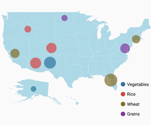
Legend alignment
Legends can be aligned using the HorizontalAlignment and VerticalAlignment Properties. By default, the legends will be aligned in center.
LegendSetting legendSetting = new LegendSetting();

            legendSetting.ShowLegend = true;

            legendSetting.LegendType = LegendType.Bubbles;

            legendSetting.LegendPosition = new Point(5, 20);

            legendSetting.HorizontalAlignment = HorizontalAlignment.Start;

            legendSetting.VerticalAlignment = VerticalAlignment.Center;

            layer.LegendSetting = legendSetting;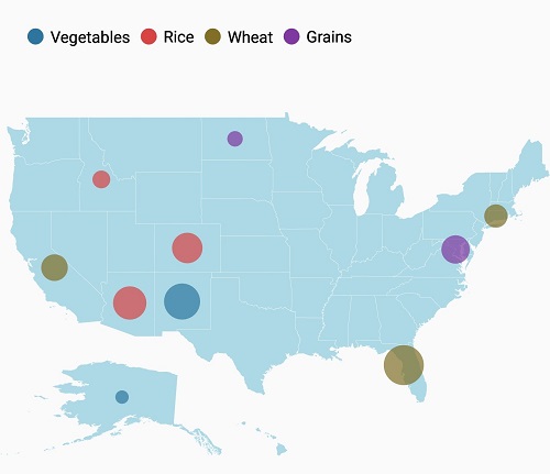
Icon customization
The icon size of a legend can be customized using the IconHeight and IconWidth properties.
LegendSetting legendSetting = new LegendSetting();
  legendSetting.ShowLegend = true;
  legendSetting.LegendPosition = new Point(75, 90);
  legendSetting.IconHeight = 20;
  legendSetting.IconWidth = 20;
  layer.LegendSetting = legendSetting;
The icon shape can be customized using the LegendIcon property. By default, this property is set to circle for bubbles and rectangle for shapes.
LegendSetting legendSetting = new LegendSetting();

legendSetting.ShowLegend = true;

legendSetting.LegendType = LegendType.Bubbles;

legendSetting.LegendIcon = LegendIcon.Diamond;

layer.LegendSetting = legendSetting;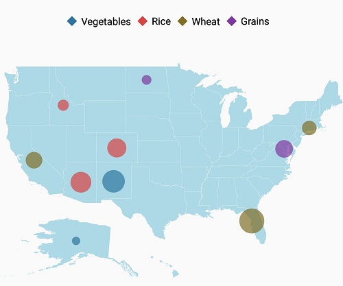
Item margin
The ItemMargin property is used to set spacing between the legend items.
LegendSetting legendSetting = new LegendSetting();

            legendSetting.ShowLegend = true;

            legendSetting.LegendType = LegendType.Bubbles;

            legendSetting.ItemMargin = 30;

            layer.LegendSetting = legendSetting;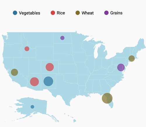
Legend label
TheLegendLabel provides an information about the maps. It is specified under color mapping. If LegendLabel is not specified, ColorMapping values will be applied as legend label.
The following properties are used to customize the label of the legends:
-
TextColor: used to change the color of the legend text. -
Typeface: used to change the font family,font weight of the legend label. -
TextSize: used to change the text size of the legend label.
LegendSetting legendSetting = new LegendSetting();

            legendSetting.ShowLegend = true;

            legendSetting.LegendType = LegendType.Bubbles;

            legendSetting.Typeface = Typeface.CreateFromAsset(Assets, "Algerian.ttf");

            legendSetting.TextColor = Color.Maroon;

            layer.LegendSettings = legendSetting;
The following code snippet explains the complete code for adding legend along with its customization.
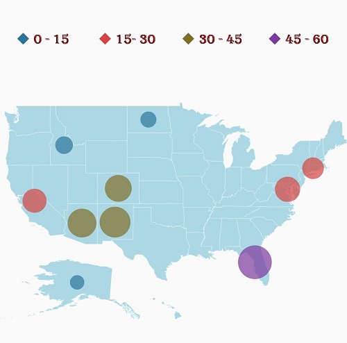
Legend for bubbles
ViewModel viewModel = new ViewModel();

            SfMaps maps = new SfMaps(this);
            maps.SetBackgroundColor(Color.White);

            ShapeFileLayer layer = new ShapeFileLayer();
            layer.Uri = "usa_state.shp";
            layer.DataSource = viewModel.DataSource;
            layer.ShapeIdTableField = "STATE_NAME";
            layer.ShapeIdPath = "Name";
            maps.Layers.Add(layer);

            BubbleMarkerSetting bubbleSetting = new BubbleMarkerSetting();
            bubbleSetting.ValuePath = "index";
            bubbleSetting.ColorValuePath = "index";
            RangeColorMapping colorMapping1 = new RangeColorMapping() { Color = Color.ParseColor("#2E769F"), From = 0, To = 15 };
            RangeColorMapping colorMapping2 = new RangeColorMapping() { Color = Color.ParseColor("#D84444"), From = 15, To = 30 };
            RangeColorMapping colorMapping3 = new RangeColorMapping() { Color = Color.ParseColor("#816F28"), From = 30, To = 45 };
            RangeColorMapping colorMapping4 = new RangeColorMapping() { Color = Color.ParseColor("#7F38A0"), From = 45, To = 50 };
            bubbleSetting.ColorMapping.Add(colorMapping1);
            bubbleSetting.ColorMapping.Add(colorMapping2);
            bubbleSetting.ColorMapping.Add(colorMapping3);
            bubbleSetting.ColorMapping.Add(colorMapping4);
            layer.BubbleMarkerSetting = bubbleSetting;

            LegendSetting legendSetting = new LegendSetting();
            legendSetting.ShowLegend = true;
            legendSetting.LegendPosition = new Point(5, 20);
            legendSetting.LegendType = LegendType.Bubbles;
            legendSetting.Typeface = Typeface.CreateFromAsset(Assets, "Algerian.ttf");
            legendSetting.TextColor = Color.Maroon;
            legendSetting.ItemMargin = 30;
            legendSetting.LegendIcon = LegendIcon.Diamond;
            legendSetting.HorizontalAlignment = HorizontalAlignment.Start;
            layer.LegendSetting = legendSetting;

            ShapeSetting shapeSetting = new ShapeSetting();
            shapeSetting.ShapeFill = Color.LightBlue;
            layer.ShapeSettings = shapeSetting;

            map.Layers.Add(layer);

            SetContentView(maps);

    public class AgricultureData
    {
        public AgricultureData(string name, string type, int count)
        {
            Name = name;
            Type = type;
            index = count;
        }

        public string Name
        {
            get;
            set;
        }

        public string Type
        {
            get;
            set;
        }

        public int index
        {
            get;
            set;
        }
    }

    public class ViewModel
    {
        public ViewModel()
        {
            DataSource = new ObservableCollection<AgricultureData>();

            DataSource.Add(new AgricultureData("Alaska", "Vegetables", 0));
            DataSource.Add(new AgricultureData("Arizona", "Rice", 36));
            DataSource.Add(new AgricultureData("California", "Wheat", 24));
            DataSource.Add(new AgricultureData("Colorado", "Rice", 31));
            DataSource.Add(new AgricultureData("North Dakota", "Grains", 4));
            DataSource.Add(new AgricultureData("Connecticut", "Wheat", 18));
            DataSource.Add(new AgricultureData("District of Columbia", "Grains", 27));
            DataSource.Add(new AgricultureData("Florida", "Wheat", 48));
            DataSource.Add(new AgricultureData("New Mexico", "Vegetables", 41));
            DataSource.Add(new AgricultureData("Idaho", "Rice", 8));

        }
        public ObservableCollection<AgricultureData> DataSource { get; set; }

    }
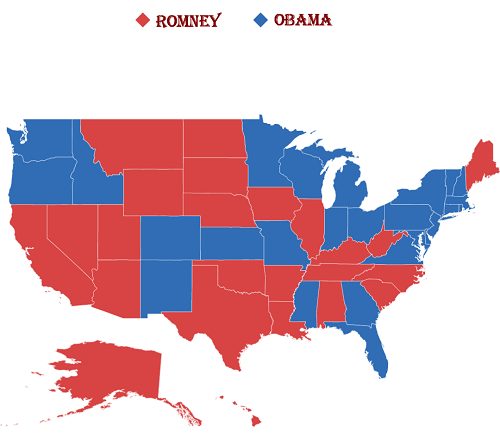
Legend for shapes
ViewModel can be retrieved from Populate data
SfMaps maps = new SfMaps(this);
            maps.SetBackgroundColor(Color.White);
            ViewModel viewModel = new ViewModel();
            ShapeFileLayer layer = new ShapeFileLayer();
            layer.Uri = "usa_state.shp";
            layer.DataSource = viewModel.Data;
            layer.ShapeIdTableField = "STATE_NAME";
            layer.ShapeIdPath = "State";

            LegendSetting legendSetting = new LegendSetting();
            legendSetting.ShowLegend = true;
            legendSetting.LegendPosition = new Point(50, 20);
            legendSetting.LegendType = LegendType.Layers;
            legendSetting.Typeface = Typeface.CreateFromAsset(Assets, "Algerian.ttf");
            legendSetting.TextColor = Color.Maroon;
            legendSetting.ItemMargin = 30;
            legendSetting.LegendIcon = LegendIcon.Diamond;
            layer.LegendSetting = legendSetting;

            EqualColorMapping colorMapping = new EqualColorMapping();
            colorMapping.Color = Color.ParseColor("#D84444");
            colorMapping.LegendLabel = "Romney";
            colorMapping.Value = "Romney";

            EqualColorMapping colorMapping1 = new EqualColorMapping();
            colorMapping1.Color = Color.ParseColor("#316DB5");
            colorMapping1.LegendLabel = "Obama";
            colorMapping1.Value = "Obama";

            ShapeSetting shapeSetting = new ShapeSetting();
            shapeSetting.ShapeValuePath = "Candidate";
            shapeSetting.ShapeColorValuePath = "Candidate";
            shapeSetting.ColorMapping.Add(colorMapping);
            shapeSetting.ColorMapping.Add(colorMapping1);

            layer.ShapeSettings = shapeSetting;
            maps.Layers.Add(layer);
            SetContentView(maps);