How can I help you?
Layers
3 Sep 202016 minutes to read
The maps control is maintained through Layers ;a map can accommodate one or more layers.
The maps control consists the following two layers:
-
Imagery layer
-
Shape file layer
Imagery layer
The MapsProvider section explains about the imagery layer.
Shape file layer
Using shape file layer, custom shape files can be rendered and the shapes can be customized.
Shape settings
This section defines how to customize the shapes in a map.
You can customize a shape’s fill, stroke, and stroke thickness using the ShapeFill,
ShapeStroke,
ShapeStrokeThickess
Refer to the following code sample for customizing shapes.
ShapeSetting shapeSetting = new ShapeSetting();
    shapeSetting.ShapeFill = Color.LightBlue;
    shapeSetting.ShapeStroke = Color.Black;
    shapeSetting.ShapeStrokeThickess = 2;
    layer.ShapeSettings = shapeSetting;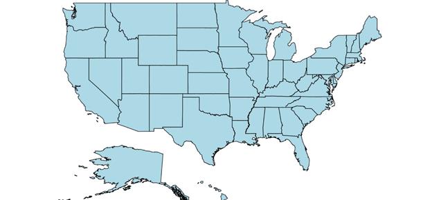
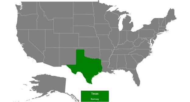
To customize the shapes based on the bound values, use the following properties:
ShapeValuePath: Field value that has to be bound for each shape.
ShapeColorValuePath: Field value that has to be bound to determine the color.
SfMaps maps = new SfMaps(this);
        maps.SetBackgroundColor(Color.White);

        ShapeFileLayer layer = new ShapeFileLayer();
        layer.Uri = "usa_state.shp";
        layer.DataSource = viewModel.Data;
        layer.ShapeIdTableField = "STATE_NAME";
        layer.ShapeIdPath = "State";
        maps.Layers.Add(layer);

        EqualColorMapping colorMapping = new EqualColorMapping();
        colorMapping.Color = Color.ParseColor("#D84444");
        colorMapping.LegendLabel = "Romney";
        colorMapping.Value = "Romney";

        EqualColorMapping colorMapping1 = new EqualColorMapping();
        colorMapping1.Color = Color.ParseColor("#316DB5");
        colorMapping1.LegendLabel = "Obama";
        colorMapping1.Value = "Obama";

        ShapeSetting shapeSetting = new ShapeSetting();
        shapeSetting.ShapeValuePath = "Candidate";
        shapeSetting.ShapeColorValuePath = "Candidate";
        shapeSetting.ColorMapping.Add(colorMapping);
        shapeSetting.ColorMapping.Add(colorMapping1);
        layer.ShapeSettings = shapeSetting;

        SetContentView(maps);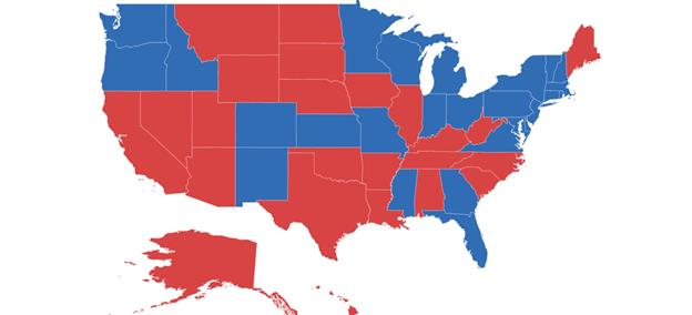
Customize selected shapes
Selection can be enabled with the help of EnableSelection property in shape file layer.
To customize the selected shapes alone, use the following properties:
SelectedShapeColor: Sets the color for selected shapes in a map.
SelectedShapeStroke: Sets the border color for selected shapes in a map.
SelectedShapeStrokeThickness: Sets the border thickness for selected shapes in a map.
ShapeFileLayer layer = new ShapeFileLayer();
        layer.Uri = "usa_state.shp";
        layer.DataSource = viewModel.Data;
        layer.ShapeIdTableField = "STATE_NAME";
        layer.ShapeIdPath = "State";
        layer.EnableSelection = true;
        maps.Layers.Add(layer);

        ShapeSetting shapeSetting = new ShapeSetting();
        shapeSetting.SelectedShapeColor = Color.DarkGreen;
        layer.ShapeSettings = shapeSetting;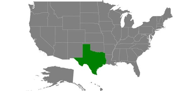
Events
The ShapeSelected event will be triggered when changing the the map shapes selection with corresponding argument as model P0 of the shape will be changed using the IsSelected property
layer.EnableSelection = true;
        layer.ShapeSelected += Layer_ShapeSelected;

        private void Layer_ShapeSelected(object sender, ShapeFileLayer.ShapeSelectedEventArgs e)
        {
                    var data = e.P0;
                    if(data !=null)
                    {
                        bool IsSelected = e.IsSelected;
                    }
        }
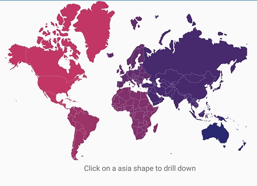
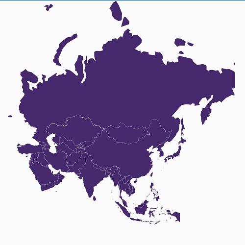
Sublayer
The shape layers are the core layers of the maps. Multiple layers can be added to the shape layers as sublayers within the shape layers.
Adding multiple layers in the map
The multiple layer can be added in the maps using Sublayer.
Displaying layer in the view
The BaseMapIndex property allows drill-down from main layer to another layer.
In the ShapeSelected event, BaseMapIndex property has been used to change the layer when Asia shape selected.
LinearLayout layout = new LinearLayout(this);
            linearLayout = new LinearLayout(this);
            TextView text3 = new TextView(this);
            text3.SetTextColor(Color.Black);
            layout.Orientation = Orientation.Vertical;
            text3.TextSize = 16;
            text3.SetPadding(10, 20, 0, 0);
            text3.Text = "Tap on a shape to drilldown";
            text3.TextAlignment = Android.Views.TextAlignment.Center;
            linearLayout.SetBackgroundColor(Color.White);
            linearLayout.AddView(text3);
            maps = new SfMaps(this);
            maps.SetBackgroundColor(Color.White);
            DrilldownViewModel viewModel = new DrilldownViewModel();
            ShapeFileLayer layer = new ShapeFileLayer();
            layer.Uri = "world-map.shp";
            layer.DataSource = viewModel.DataSource;
            layer.ShapeIdTableField = "admin";
            layer.ShapeIdPath = "Country";
            layer.EnableSelection = true;
            EqualColorMapping colorMapping = new EqualColorMapping();
            colorMapping.Color = Color.ParseColor("#C13664");
            colorMapping.Value = "North America";

            EqualColorMapping colorMapping1 = new EqualColorMapping();
            colorMapping1.Color = Color.ParseColor("#9C3367");
            colorMapping1.Value = "South America";

            EqualColorMapping colorMapping2 = new EqualColorMapping();
            colorMapping2.Color = Color.ParseColor("#80306A");
            colorMapping2.Value = "Africa";

            EqualColorMapping colorMapping3 = new EqualColorMapping();
            colorMapping3.Color = Color.ParseColor("#622D6C");
            colorMapping3.Value = "Europe";

            EqualColorMapping colorMapping4 = new EqualColorMapping();
            colorMapping4.Color = Color.ParseColor("#462A6D");
            colorMapping4.Value = "Asia";

            EqualColorMapping colorMapping5 = new EqualColorMapping();
            colorMapping5.Color = Color.ParseColor("#2A2870");
            colorMapping5.Value = "Australia";

            ShapeSetting shapeSetting = new ShapeSetting();
            shapeSetting.ShapeColorValuePath = "Continent";
            shapeSetting.ColorMapping.Add(colorMapping);
            shapeSetting.ColorMapping.Add(colorMapping1);
            shapeSetting.ColorMapping.Add(colorMapping2);
            shapeSetting.ColorMapping.Add(colorMapping3);
            shapeSetting.ColorMapping.Add(colorMapping4);
            shapeSetting.ColorMapping.Add(colorMapping5);
            layer.ShapeSettings = shapeSetting;

            ShapeFileLayer layer1 = new ShapeFileLayer();
            layer1.Uri = "asia.shp";
            layer1.ShapeSettings.ShapeFill = Color.ParseColor("#462A6D");

            layer.ShapeSelected += Layer_ShapeSelected;

            maps.Layers.Add(layer);
            maps.Layers.Add(layer1);
            layout.AddView(linearLayout);
            layout.AddView(maps);
            SetContentView(layout);

        private void Layer_ShapeSelected(object sender, ShapeFileLayer.ShapeSelectedEventArgs e)
        {
            maps.BaseMapIndex = 1;
            linearLayout.Visibility = Android.Views.ViewStates.Invisible;
        }

        public class DrilldownViewModel
        {
          public DrilldownViewModel()
          {
              DataSource = new ObservableCollection<DrilldownModel>();
              DataSource.Add(new DrilldownModel("Afghanistan", "Asia"));
              DataSource.Add(new DrilldownModel("Angola", "Africa"));
              DataSource.Add(new DrilldownModel("Albania", "Europe"));
              DataSource.Add(new DrilldownModel("United Arab Emirates", "Asia"));
              DataSource.Add(new DrilldownModel("Argentina", "South America"));
              DataSource.Add(new DrilldownModel("Armenia", "Asia"));
              DataSource.Add(new DrilldownModel("French Southern and Antarctic Lands", "Seven seas (open ocean)"));
              DataSource.Add(new DrilldownModel("Australia", "Australia"));

              //...
              //...

              DataSource.Add(new DrilldownModel("Zambia", "Africa"));
              DataSource.Add(new DrilldownModel("Zimbabwe", "Africa"));
          }
          public ObservableCollection<DrilldownModel> DataSource { get; set; }
        }

    public class DrilldownModel
    {
        public DrilldownModel(string country, string con)
        {
            this.Country = country;
            this.Continent = con;
        }
        public string Continent
        {
            get;
            set;
        }
        public string Country
        {
            get;
            set;
        }

    }