Shape Types in UWP Maps (SfMaps)
20 Oct 202224 minutes to read
This feature allows you to draw a polygon, polyline, or circle on the map. You can provide input as Geo points to draw shapes in two different ways:
1.Add shapes using map element collection
2.Add shapes using point collection
Add shapes using map element collection
You can provide input as a Geo points collection to add multiple shapes in a single layer by using the MapElements property of shape layer. There are three types of shapes available in map element.
1.MapPolygon
2.MapPolyline
3.MapCircle
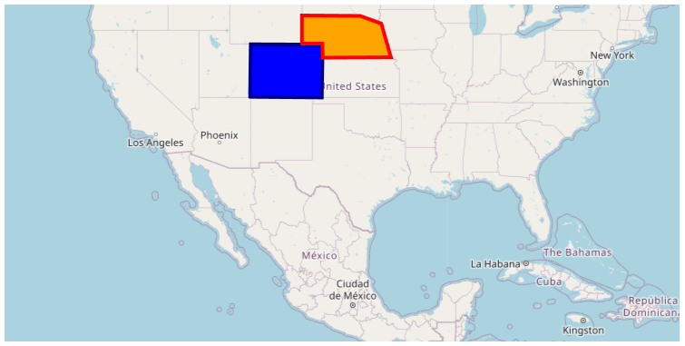
MapPolygon
You can add polygon shape on map using MapPolygon class and provide Geo points collection to Points property. Polygon shape type is used to defines a group of land, water bodies, and other features with a spatial extent.
<Grid Margin="20">
        <Grid.Resources>
            <local:ViewModel x:Key="viewModel"/>
        </Grid.Resources>
        <maps:SfMap x:Name="Maps" ZoomLevel="4" DataContext="{StaticResource viewModel}">
            <maps:SfMap.Layers>
                <maps:ImageryLayer  x:Name="layer" GeoCoordinates="30.9709225,-100.2187212">
                    <maps:ImageryLayer.SubShapeFileLayers>
                        <maps:SubShapeFileLayer x:Name="subLayer">
                            <maps:SubShapeFileLayer.MapElements>

                                <maps:MapPolygon Points="{Binding PolygonPoints1, Source={StaticResource viewModel}}" Fill="Blue" Stroke="DarkBlue"
                                               StrokeThickness="4"/>

                                <maps:MapPolygon Points="{Binding PolygonPoints2, Source={StaticResource viewModel}}" Fill="Orange" Stroke="Red"
                                               StrokeThickness="4"/>

                            </maps:SubShapeFileLayer.MapElements>
                        </maps:SubShapeFileLayer>
                    </maps:ImageryLayer.SubShapeFileLayers>
                </maps:ImageryLayer>
            </maps:SfMap.Layers>
        </maps:SfMap>
    </Grid>
public partial class MyPage : ContentPage
{
public MyPage()
{
InitializeComponent();
ViewModel viewModel = new ViewModel();
SfMap maps = new SfMap();
maps.ZoomLevel = 4;
ImageryLayer layer = new ImageryLayer();
SubShapeFileLayer subLayer = new SubShapeFileLayer();
layer.GeoCoordinates = new Point(30.9709225, -100.2187212);
MapPolygon mapPolygon = new MapPolygon();
mapPolygon.Fill = new SolidColorBrush(Colors.Blue);
mapPolygon.Stroke = new SolidColorBrush(Colors.DarkBlue);
mapPolygon.StrokeThickness = 4;
mapPolygon.Points = viewModel.PolygonPoints1;
subLayer.MapElements.Add(mapPolygon);
mapPolygon = new MapPolygon();
mapPolygon.Fill = new SolidColorBrush(Colors.Orange);
mapPolygon.Stroke = new SolidColorBrush(Colors.Red);
mapPolygon.StrokeThickness = 4;
mapPolygon.Points = viewModel.PolygonPoints2;
subLayer.MapElements.Add(mapPolygon);
layer.SubShapeFileLayers.Add(subLayer);
maps.Layers.Add(layer);
this.Content = maps;
}
}
public class ViewModel
{
public ObservableCollection<Point> PolygonPoints1
{
get; set;
}
public ObservableCollection<Point> PolygonPoints2
{
get; set;
}
public ViewModel()
{
PolygonPoints1 = new ObservableCollection<Point>()
{
new Point(37.042972,-109.085003),
new Point(40.992567,-109.021030),
new Point(40.968420,-102.048065),
new Point(36.991893,-102.144024),
new Point(37.042972,-109.085003)
};
PolygonPoints2 = new ObservableCollection<Point>()
{
new Point(41.04621681452063, -104.0625),
new Point(41.04621681452063, -102.0849609375),
new Point(40.01078714046552, -102.041015625),
new Point(40.04443758460856, -95.44921875),
new Point(42.48830197960227, -96.3720703125),
new Point(43.03677585761058, -98.4375),
new Point(43.068887774169625, -104.0625),
new Point(41.04621681452063, -104.0625),
};
}
}
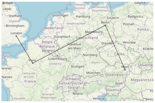
MapPolyline
You can add polyline shape on map using MapPolyline class and provide Geo points collection to Points. Polylines are frequently used to define linear features such as roads, rivers, and power lines.
<maps:SfMap x:Name="Maps" ZoomLevel="5">
            <maps:SfMap.Layers>
                <maps:ImageryLayer  x:Name="layer" GeoCoordinates="49.9709225,10.2187212">
                    <maps:ImageryLayer.SubShapeFileLayers>
                        <maps:SubShapeFileLayer x:Name="subLayer" >
                            <maps:SubShapeFileLayer.MapElements>

                                <maps:MapPolyline Stroke="Black">
                                    <maps:MapPolyline.Points>
                                        <p:Point>51.5008, -0.1224</p:Point>
                                        <p:Point>48.8567, 2.3508</p:Point>
                                        <p:Point>52.5166, 13.3833</p:Point>
                                        <p:Point>48.21327949272514, 16.388290236693138</p:Point>
                                    </maps:MapPolyline.Points>
                                </maps:MapPolyline>

                            </maps:SubShapeFileLayer.MapElements>
                        </maps:SubShapeFileLayer>
                    </maps:ImageryLayer.SubShapeFileLayers>
                </maps:ImageryLayer>
            </maps:SfMap.Layers>
        </maps:SfMap>
public partial class MyPage : ContentPage
{
public MyPage()
{
InitializeComponent();
SfMap maps = new SfMap();
maps.ZoomLevel = 5;
ImageryLayer layer = new ImageryLayer();
layer.GeoCoordinates = new Point(49.9709225, 10.2187212);
SubShapeFileLayer subLayer = new SubShapeFileLayer();
MapPolyline mapPolyline = new MapPolyline();
mapPolyline.Stroke = new SolidColorBrush(Colors.Black);
mapPolyline.Points = new ObservableCollection<Point>()
{
new Point(51.5008, -0.1224),
new Point(48.8567, 2.3508),
new Point(52.5166, 13.3833),
new Point(48.21327949272514, 16.388290236693138)
};
subLayer.MapElements.Add(mapPolyline);
layer.SubShapeFileLayers.Add(subLayer);
maps.Layers.Add(layer);
this.Content = maps;
}
}
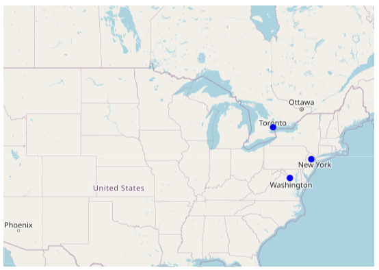
MapCircle
A circle has a single Geo coordinate value and it can be positioned on map using Center property of MapCircle. The circles are often used to define features such as oil wells, landmarks, and elevations.
-
Center- Holds latitude and longitude values that defines the center of the circle.<maps:SfMap x:Name="Maps" ZoomLevel="4"> <maps:SfMap.Layers> <maps:ImageryLayer x:Name="layer" GeoCoordinates="42.9709225,-90.2187212"> <maps:ImageryLayer.SubShapeFileLayers> <maps:SubShapeFileLayer x:Name="subLayer" > <maps:SubShapeFileLayer.MapElements> <maps:MapCircle Fill="Blue"> <maps:MapCircle.Center> <p:Point>43.76140927456403, -79.35451013248883</p:Point> </maps:MapCircle.Center> </maps:MapCircle> <maps:MapCircle Fill="Blue"> <maps:MapCircle.Center> <p:Point>40.7324105, -74.4416047</p:Point> </maps:MapCircle.Center> </maps:MapCircle> <maps:MapCircle Fill="Blue"> <maps:MapCircle.Center> <p:Point>38.8781708, -77.1889971</p:Point> </maps:MapCircle.Center> </maps:MapCircle> </maps:SubShapeFileLayer.MapElements> </maps:SubShapeFileLayer> </maps:ImageryLayer.SubShapeFileLayers> </maps:ImageryLayer> </maps:SfMap.Layers> </maps:SfMap>public partial class MyPage : ContentPage { public MyPage() { InitializeComponent(); SfMap maps = new SfMap(); maps.ZoomLevel = 4; ImageryLayer layer = new ImageryLayer(); layer.GeoCoordinates = new Point(42.9709225, -90.2187212); SubShapeFileLayer subLayer = new SubShapeFileLayer(); MapCircle mapCircle = new MapCircle(); mapCircle.Fill = new SolidColorBrush(Colors.Blue); mapCircle.Center = new Point(43.76140927456403, -79.35451013248883); subLayer.MapElements.Add(mapCircle); mapCircle = new MapCircle(); mapCircle.Fill = new SolidColorBrush(Colors.Blue); mapCircle.Center = new Point(40.7324105, -74.4416047); subLayer.MapElements.Add(mapCircle); mapCircle = new MapCircle(); mapCircle.Fill = new SolidColorBrush(Colors.Blue); mapCircle.Center = new Point(38.8781708, -77.1889971); subLayer.MapElements.Add(mapCircle); layer.SubShapeFileLayers.Add(subLayer); maps.Layers.Add(layer); this.Content = maps; } }
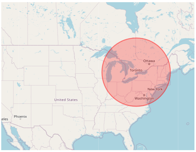
Customization of map elements
The following properties are used to customize MapPolygon, MapPolyline, and MapCircle.
-
Fill,Stroke,StrokeThickness- Used to customize the appearance of the map element’s shape UI. -
Radius- Used to customize radius or range of the map circle. This property is available only forMapCircle.
<maps:SfMap x:Name="Maps" ZoomLevel="4">
            <maps:SfMap.Layers>
                <maps:ImageryLayer  x:Name="layer" GeoCoordinates="42.9709225,-90.2187212">
                    <maps:ImageryLayer.SubShapeFileLayers>
                        <maps:SubShapeFileLayer x:Name="subLayer" >
                            <maps:SubShapeFileLayer.MapElements>

                                <maps:MapCircle Fill="#3eFF0000" Stroke="#73FF0000"
                                                StrokeThickness="3" Radius="110">
                                    <maps:MapCircle.Center>
                                        <p:Point>43.76140927456403, -79.35451013248883</p:Point>
                                    </maps:MapCircle.Center>
                                </maps:MapCircle>

                            </maps:SubShapeFileLayer.MapElements>
                        </maps:SubShapeFileLayer>
                    </maps:ImageryLayer.SubShapeFileLayers>
                </maps:ImageryLayer>
            </maps:SfMap.Layers>
        </maps:SfMap>
public partial class MyPage : ContentPage
{
public MyPage()
{
InitializeComponent();
SfMap maps = new SfMap();
maps.ZoomLevel = 4;
ImageryLayer layer = new ImageryLayer();
layer.GeoCoordinates = new Point(42.9709225, -90.2187212);
SubShapeFileLayer subLayer = new SubShapeFileLayer();
MapCircle mapCircle = new MapCircle();
mapCircle.Fill = new SolidColorBrush(Color.FromArgb(115, 255, 0, 0));
mapCircle.StrokeThickness = 3;
mapCircle.Stroke = new SolidColorBrush(Color.FromArgb(62, 255, 0, 0));
mapCircle.Radius = 110;
mapCircle.Center = new Point(43.76140927456403, -79.35451013248883);
subLayer.MapElements.Add(mapCircle);
layer.SubShapeFileLayers.Add(subLayer);
maps.Layers.Add(layer);
this.Content = maps;
}
}
Add shapes using point collection
You can add more number of shapes on map by using SubShapeFileLayer and Points collection property which contains the Geo coordinate points to draw a shape. In shape file layer, there are three type of shapes available and it can be changed by using the ShapeType property.
1.Polygon
2.Polyline
3.Point icon
You can customize the appearance of the shape UI by setting ShapeFill, ShapeStroke, and ShapeStrokeThickness properties in ShapeSetting.
Polygon
You can add polygon shape on map by using Points collection property of shape layer or sub layer and set ShapeType as Polygon. Polygon shape type defines a group of land, water bodies, and other features with a spatial extent.
<maps:SfMap x:Name="maps" ZoomLevel="4">
            <maps:SfMap.Layers>
                <maps:ImageryLayer GeoCoordinates="30.9709225,-100.2187212" >
                    <maps:ImageryLayer.SubShapeFileLayers>
                        <maps:SubShapeFileLayer  x:Name="sublayer1" ShapeType="Polygon" Points="{Binding SubLayer1}">
                            <maps:SubShapeFileLayer.ShapeSettings>
                                <maps:ShapeSetting ShapeFill="Blue" ShapeStroke="DarkBlue"
                                               ShapeStrokeThickness="4" />
                            </maps:SubShapeFileLayer.ShapeSettings>
                        </maps:SubShapeFileLayer>
                        <maps:SubShapeFileLayer  x:Name="sublayer2" ShapeType="Polygon" Points="{Binding SubLayer2}">
                            <maps:SubShapeFileLayer.ShapeSettings>
                                <maps:ShapeSetting ShapeFill="Orange" ShapeStroke="Red"
                                               ShapeStrokeThickness="4" />
                            </maps:SubShapeFileLayer.ShapeSettings>
                        </maps:SubShapeFileLayer>
                    </maps:ImageryLayer.SubShapeFileLayers>
                </maps:ImageryLayer>
            </maps:SfMap.Layers>
        </maps:SfMap>
public partial class MainPage : ContentPage
{
ViewModel obj = new ViewModel();
public MainPage()
{
InitializeComponent();
this.DataContext = obj;
SfMap maps = new SfMap();
maps.ZoomLevel = 4;
ImageryLayer layer = new ImageryLayer();
layer.GeoCoordinates = new Point(30.9709225, -100.2187212);
SubShapeFileLayer subLayer1 = new SubShapeFileLayer();
subLayer1.ShapeType = ShapeType.Polygon;
subLayer1.Points = obj.SubLayer1;
layer.SubShapeFileLayers.Add(subLayer1);
SubShapeFileLayer subLayer2 = new SubShapeFileLayer();
subLayer2.ShapeType = ShapeType.Polygon;
subLayer1.Points = obj.SubLayer2;
layer.SubShapeFileLayers.Add(subLayer2);
ShapeSetting subLayerSetting1 = new ShapeSetting();
subLayerSetting1.ShapeStrokeThickness = 4;
subLayerSetting1.ShapeFill = new SolidColorBrush(Colors.Blue);
subLayerSetting1.ShapeStroke = new SolidColorBrush(Colors.DarkBlue);
subLayer1.ShapeSettings = subLayerSetting1;
ShapeSetting subLayerSetting2 = new ShapeSetting();
subLayerSetting2.ShapeStrokeThickness = 4;
subLayerSetting2.ShapeFill = new SolidColorBrush(Colors.Orange);
subLayerSetting2.ShapeStroke = new SolidColorBrush(Colors.Red);
subLayer2.ShapeSettings = subLayerSetting2;
subLayer1.Points = obj.SubLayer1;
subLayer2.Points = obj.SubLayer2;
maps.Layers.Add(layer);
this.Content = maps;
}
}
public class ViewModel
{
public ObservableCollection<Point> SubLayer1
{
get;set;
}
public ObservableCollection<Point> SubLayer2
{
get; set;
}
public ViewModel()
{
SubLayer1 = new ObservableCollection<Point>()
{
new Point(37.042972,-109.085003),
new Point(40.992567,-109.021030),
new Point(40.968420,-102.048065),
new Point(36.991893,-102.144024),
new Point(37.042972,-109.085003)
};
SubLayer2 = new ObservableCollection<Point>()
{
new Point(41.04621681452063, -104.0625),
new Point(41.04621681452063, -102.0849609375),
new Point(40.01078714046552, -102.041015625),
new Point(40.04443758460856, -95.44921875),
new Point(42.48830197960227, -96.3720703125),
new Point(43.03677585761058, -98.4375),
new Point(43.068887774169625, -104.0625),
new Point(41.04621681452063, -104.0625),
};
}
}
Polyline
You can add polyline shape on map by using Points collection property of shape layer or sub layer and set ShapeType as Polyline. Polylines are frequently used to define linear features such as roads, rivers, and power lines.
<maps:SfMap x:Name="Maps" ZoomLevel="5">
            <maps:SfMap.Layers>
                <maps:ImageryLayer  x:Name="layer" GeoCoordinates="49.9709225,10.2187212">
                    <maps:ImageryLayer.SubShapeFileLayers>
                        <maps:SubShapeFileLayer x:Name="subLayer" ShapeType="Polyline">
                            <maps:SubShapeFileLayer.Points>
                                <p:Point>51.5008, -0.1224</p:Point>
                                <p:Point>48.8567, 2.3508</p:Point>
                                <p:Point>52.5166, 13.3833</p:Point>
                                <p:Point>48.21327949272514, 16.388290236693138</p:Point>

                            </maps:SubShapeFileLayer.Points>
                            <maps:SubShapeFileLayer.ShapeSettings>
                                <maps:ShapeSetting x:Name="settings" ShapeFill="Black" ShapeStrokeThickness="1"/>
                            </maps:SubShapeFileLayer.ShapeSettings>
                        </maps:SubShapeFileLayer>
                    </maps:ImageryLayer.SubShapeFileLayers>
                </maps:ImageryLayer>
            </maps:SfMap.Layers>
        </maps:SfMap>
public partial class MyPage : ContentPage
{
public MyPage()
{
InitializeComponent();
SfMap maps = new SfMap();
maps.ZoomLevel = 5;
ImageryLayer layer = new ImageryLayer();
layer.GeoCoordinates = new Point(49.9709225, 10.2187212);
SubShapeFileLayer subLayer = new SubShapeFileLayer();
subLayer.Points = new ObservableCollection<Point>()
{
new Point(51.5008, -0.1224),
new Point(48.8567, 2.3508),
new Point(52.5166, 13.3833),
new Point(48.21327949272514, 16.388290236693138)
};
subLayer.ShapeType = ShapeType.Polyline;
ShapeSetting subLayerSetting = new ShapeSetting();
subLayerSetting.ShapeStrokeThickness = 1;
subLayerSetting.ShapeFill = new SolidColorBrush(Colors.Black);
subLayer.ShapeSettings = subLayerSetting;
layer.SubShapeFileLayers.Add(subLayer);
maps.Layers.Add(layer);
this.Content = maps;
}
}
Point icon
A point icon has a single Geo coordinate value and you can add multi point icon shapes on map by using Points collection property of shape layer or sub layer and set ShapeType as PointIcon. The point icons are often used to define features such as oil wells, landmarks, and elevations.
The size, shape, and alignment of the map points can be customized using the MapPointIconSize, MapPointIcon, MapPointHorizontalAlignment, and MapPointVerticalAlignment properties of the shape file layer.
<maps:SfMap x:Name="Maps" ZoomLevel="4">
            <maps:SfMap.Layers>
                <maps:ImageryLayer  x:Name="layer" GeoCoordinates="42.9709225,-90.2187212">
                    <maps:ImageryLayer.SubShapeFileLayers>
                        <maps:SubShapeFileLayer x:Name="subLayer" MapPointIconSize="10"
                                                ShapeType="PointIcon">
                            <maps:SubShapeFileLayer.Points>
                                <p:Point>43.96140927456403, -79.85451013248883</p:Point>
                                <p:Point>41.1324105, -74.4416047</p:Point>
                                <p:Point>39.2781708, -77.5889971</p:Point>
                            </maps:SubShapeFileLayer.Points>
                            <maps:ShapeFileLayer.ShapeSettings>
                                <maps:ShapeSetting ShapeFill="Blue"/>
                            </maps:ShapeFileLayer.ShapeSettings>
                        </maps:SubShapeFileLayer>
                    </maps:ImageryLayer.SubShapeFileLayers>
                </maps:ImageryLayer>
            </maps:SfMap.Layers>
        </maps:SfMap>
public partial class MyPage : ContentPage
{
public MyPage()
{
InitializeComponent();
SfMap maps = new SfMap();
maps.ZoomLevel = 4;
ImageryLayer layer = new ImageryLayer();
layer.GeoCoordinates = new Point(42.9709225, -90.2187212);
SubShapeFileLayer subLayer = new SubShapeFileLayer();
subLayer.Points.Add(new Point(43.96140927456403, -79.85451013248883));
subLayer.Points.Add(new Point(41.1324105, -74.4416047));
subLayer.Points.Add(new Point(39.2781708, -77.5889971));
subLayer.MapPointIconSize = 10;
subLayer.ShapeType = ShapeType.PointIcon;
subLayer.MapPointIconSize = 10;
ShapeSetting subLayerSetting = new ShapeSetting();
subLayerSetting.ShapeFill = new SolidColorBrush(Colors.Blue);
subLayer.ShapeSettings = subLayerSetting;
layer.SubShapeFileLayers.Add(subLayer);
maps.Layers.Add(layer);
this.Content = maps;
}
}