Multilayer Support in UWP Map (SfMaps)
10 May 202124 minutes to read
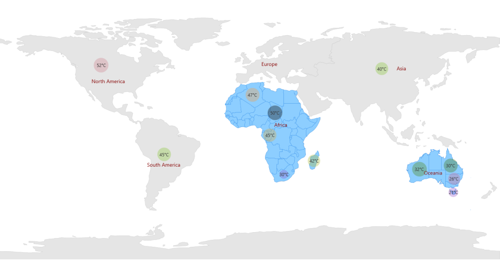
Multilayer support allows you to load multiple shapefiles in a single container, enabling maps to display more detail.
Loading Multiple Shapefiles in a Single Container
This feature enables the map to load multiple types of shapefiles in a single container. Basically, shape files contain point shapes in a single container.
Situations arise where, any combination of available shapefiles needs to be loaded in a single container. In such situations this feature enables the map to load multiple shape layers in a single container.
Adding Multiple Layers in the Map
ShapeFileLayer is the core layer for the map. Multiple layers can be added in the ShapeFileLayer itself. They have to be added in SubShapeFileLayers within the ShapeFileLayer.
SubShapeFileLayers
SubShapeFileLayers is the collection of SubShapeFileLayer. SubShapeFileLayer is also a type of shapefile layer. The following code adds multiple layers in the ShapeFileLayer.
<syncfusion:SfMap>
           <syncfusion:SfMap.Layers>
               <syncfusion:ShapeFileLayer ShapeIDPath="NAME"  ShapeIDTableField="Continent"
                                    EnableSelection="True”
                                    Uri=" MapApp.ShapeFiles.continent.shp">
                     <syncfusion:ShapeFileLayer.ItemsTemplate>
                           <DataTemplate>
                                <Border Visibility="{Binding Data.ItemsVisibility}" Background="Transparent">
                                    <StackPanel Orientation="Horizontal">
                                         <TextBlock FontFamily="Segoe UI" Foreground="#FF333333" FontSize="12" Text="{Binding Data.Weather}"/>
                                         <TextBlock FontFamily="Segoe UI" Foreground="#FF333333" FontSize="12"
                                              Text="°C"/>
                                     </StackPanel>
                                 </Border>
                           </DataTemplate>
                  </syncfusion:ShapeFileLayer.ItemsTemplate>
            <syncfusion:ShapeFileLayer.ShapeSettings>
                <syncfusion:ShapeSetting ShapeStroke="#C1C1C1" ShapeStrokeThickness="0.5"
                        ShapeValuePath="Weather" ShapeFill="#E5E5E5"/>
                </syncfusion:ShapeFileLayer.ShapeSettings>
            <syncfusion:ShapeFileLayer.SubShapeFileLayers>
               <syncfusion:SubShapeFileLayer ShapeIDPath="NAME" ItemsSource="{Binding AfricaList}"
                                              ShapeIDTableField="Country"
                                              Uri=” MapApp.ShapeFiles.Africa.shp">
                    <syncfusion:SubShapeFileLayer.ItemsTemplate>
                        <DataTemplate>
                            <Border  Background="Transparent">
                                <StackPanel Orientation="Horizontal">
                                     <TextBlock FontFamily="Segoe UI" Foreground="#FF333333"
                                                FontSize="12"  Text="{Binding Data.Weather}"/>
                                     <TextBlock FontFamily="Segoe UI" Foreground="#FF333333"
                                                FontSize="12"  Text="°C"/>
                                </StackPanel>
                              </Border>
                         </DataTemplate>
                    </syncfusion:SubShapeFileLayer.ItemsTemplate>
                         <syncfusion:SubShapeFileLayer.ShapeSettings>
                             <syncfusion:ShapeSetting ShapeStroke="#2F8CEA"
                                                      ShapeValuePath="Weather" ShapeFill="#8DCEFF">
                             </syncfusion:ShapeSetting>
                         </syncfusion:SubShapeFileLayer.ShapeSettings>
                   </syncfusion:SubShapeFileLayer>
                   <syncfusion:SubShapeFileLayer ShapeIDPath="NAME" ShapeIDTableField="ADMIN_NAME"
                                               ItemsSource="{Binding OceaniaList}"
                                               Uri=" MapApp.ShapeFiles.Australia.shp">
                       <syncfusion:SubShapeFileLayer.ShapeSettings>
                           <syncfusion:ShapeSetting ShapeStroke="#2F8CEA" ShapeValuePath="Weather"
                                                                             ShapeFill="#8DCEFF"/>
                           </syncfusion:SubShapeFileLayer.ShapeSettings>
                           <syncfusion:SubShapeFileLayer.ItemsTemplate>
                                    <DataTemplate>
                                        <Border Background="Transparent">
                                            <StackPanel Orientation="Horizontal">
                                                <TextBlock FontFamily="Segoe UI"
                                                           Foreground="#FF333333" FontSize="12"
                                                           Text="{Binding Data.Weather}"/>
                                                <TextBlock FontFamily="Segoe UI"
                                                            Foreground="#FF333333" FontSize="12"
                                                           Text="°C"/>
                                            </StackPanel>
                                        </Border>
                                    </DataTemplate>
                                </syncfusion:SubShapeFileLayer.ItemsTemplate>
                           </syncfusion:SubShapeFileLayer>
                       </syncfusion:ShapeFileLayer.SubShapeFileLayers>
                    </syncfusion:ShapeFileLayer>
            </syncfusion:SfMap.Layers>
        </syncfusion:SfMap>
public class Country : INotifyPropertyChanged
{
public string NAME { get; set; }
private Visibility visibility = Visibility.Visible;
public Visibility ItemsVisibility
{
get { return visibility; }
set { visibility = value; }
}
private double weather { get; set; }
public double Weather
{
get
{
return weather;
}
set
{
weather = value;
}
}
private double population { get; set; }
public double Population
{
get
{
return population;
}
set
{
population = value;
OnPropertyChanged(new PropertyChangedEventArgs("Population"));
}
}
public string PopulationFormat { get; set; }
public event PropertyChangedEventHandler PropertyChanged;
public void OnPropertyChanged(PropertyChangedEventArgs e)
{
this.PopulationFormat = (String.Format("{0:0,0}", this.Population).Trim('$'));
if (PropertyChanged != null)
{
PropertyChanged(this, e);
}
}
}
public class MapViewModel
{
public ObservableCollection<Country> Multilayer { get; set; }
public ObservableCollection<Country> AfricaList { get; set; }
public ObservableCollection<Country> OceaniaList { get; set; }
public MapViewModel()
{
this.OceaniaList.Add(new Country() { NAME = "New South Wales", Weather = 26 });
this.OceaniaList.Add(new Country() { NAME = "Queensland", Weather = 30 });
this.OceaniaList.Add(new Country() { NAME = "Tasmania", Weather = 21 });
this.OceaniaList.Add(new Country() { NAME = "Western Australia", Weather = 32 });
this.AfricaList = new ObservableCollection<Country>();
this.AfricaList.Add(new Country() { NAME = "Algeria", Weather = 47 });
this.AfricaList.Add(new Country() { NAME = "Congo (Brazzaville)", Weather = 45 });
this.AfricaList.Add(new Country() { NAME = "Ethiopia", Weather = 50 });
this.AfricaList.Add(new Country() { NAME = "South Africa", Weather = 30 });
this.Multilayer = new ObservableCollection<Country>();
this.Multilayer.Add(new Country() { NAME = "Asia", Weather = 40 });
this.Multilayer.Add(new Country() { NAME = "South America", Weather = 45 });
this.Multilayer.Add(new Country() { NAME = "North America", Weather = 52 });
this.Multilayer.Add(new Country() { NAME = "Antarctica", ItemsVisibility = Visibility.Collapsed });
this.Multilayer.Add(new Country() { NAME = "Oceania", ItemsVisibility = Visibility.Collapsed });
this.Multilayer.Add(new Country() { NAME = "Europe", ItemsVisibility = Visibility.Collapsed });
this.Multilayer.Add(new Country() { NAME = "Africa", ItemsVisibility = Visibility.Collapsed });
}
}
Layout type
The LayoutType defines how to project the map. This can be categorized into the following types:
- Default
- Tile
Default
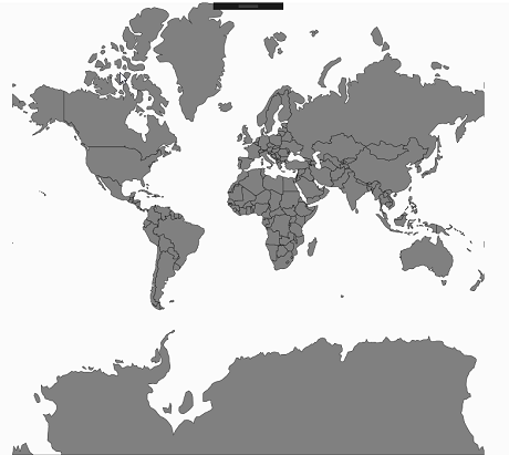
In the default layout, the maps will be rendered based on the given points of shape file without any further manipulation of maps scale.
<syncfusion:ShapeFileLayer  x:Name="shapelayer" Uri="Maps.Assets.world1.shp" LayoutType="Default">
                    <syncfusion:ShapeFileLayer.ShapeSettings>
                        <syncfusion:ShapeSetting ShapeFill="Gray" ShapeStroke="Black"
                                                 ShapeStrokeThickness="0.5"></syncfusion:ShapeSetting>
                    </syncfusion:ShapeFileLayer.ShapeSettings>
</syncfusion:ShapeFileLayer>ShapeFileLayer layer = new ShapeFileLayer();
layer.Uri = "Maps.Assets.world1.shp";
layer.LayoutType = LayoutType.Default;
ShapeSetting setting = new ShapeSetting();
setting.ShapeFill = new SolidColorBrush(Colors.Gray);
setting.ShapeStroke= new SolidColorBrush(Colors.Black);
setting.ShapeStrokeThickness = 0.5;
layer.ShapeSettings = setting;
map.Layers.Add(layer);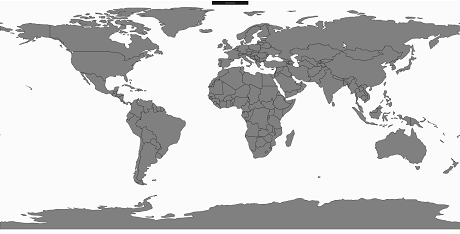
Tile
In the tile layout, the maps scale value is maintained in every direction around a point. Therefore, the shapes are represented accurately and without distortion for small areas
<syncfusion:ShapeFileLayer  x:Name="shapelayer" Uri="Maps.Assets.world1.shp" LayoutType="Tile">
                    <syncfusion:ShapeFileLayer.ShapeSettings>
                        <syncfusion:ShapeSetting ShapeFill="Gray" ShapeStroke="Black"
                                                 ShapeStrokeThickness="0.5"></syncfusion:ShapeSetting>
                    </syncfusion:ShapeFileLayer.ShapeSettings>
</syncfusion:ShapeFileLayer>ShapeFileLayer layer = new ShapeFileLayer();
layer.Uri = "Maps.Assets.world1.shp";
layer.LayoutType = LayoutType.Tile;
ShapeSetting setting = new ShapeSetting();
setting.ShapeFill = new SolidColorBrush(Colors.Gray);
setting.ShapeStroke= new SolidColorBrush(Colors.Black);
setting.ShapeStrokeThickness = 0.5;
layer.ShapeSettings = setting;
map.Layers.Add(layer);