Annotations in Windows Forms Maps
18 Nov 20189 minutes to read
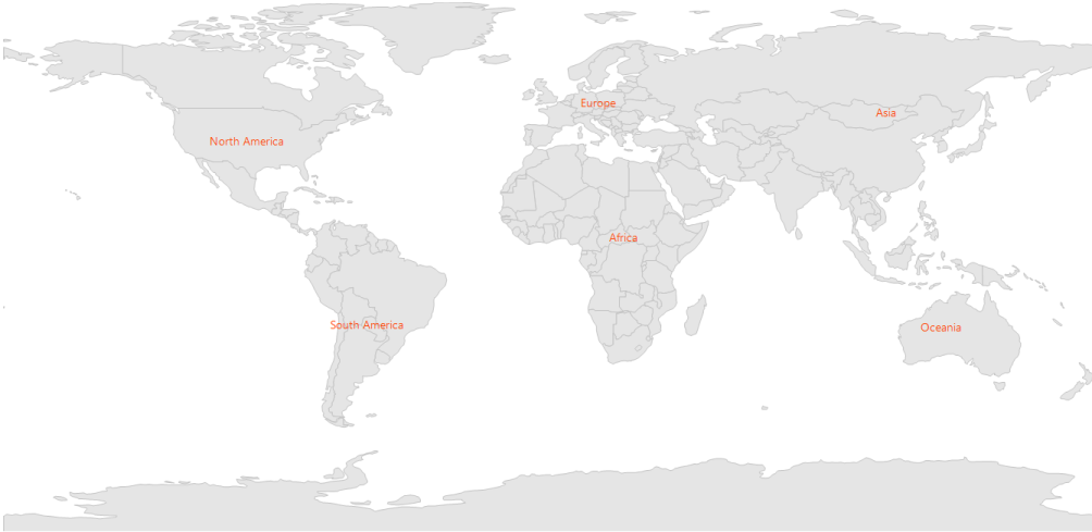
Annotations are used to add messages on the map. In Maps control, annotations are denoted using the following major properties:
-
AnnotationLabel: Shows some information in text format. -
AnnotationStroke: Applies specific color to annotations. -
LatitudeandLongitude: Position the annotations anywhere on the map based on latitude and longitude, which are string types, used to set coordinates of the MapAnnotation in the form of latitude and longitude.
Code sample:
partial class Form1
{
    private Syncfusion.Windows.Forms.Maps.Maps mapsControl1;

    private void InitializeComponent()
    {
        this.mapsControl1 = new Syncfusion.Windows.Forms.Maps.Maps();
        this.mapsControl1.Name = "mapsControl1";
        this.mapsControl1.Size = new System.Drawing.Size(880, 585);
        this.Controls.Add(this.mapsControl1);
        this.ClientSize = new System.Drawing.Size(880, 585);
        this.Load += new System.EventHandler(this.Form1_Load);
    }
}
Partial Class Form1
Private mapsControl1 As Syncfusion.Windows.Forms.Maps.Maps
Private Sub InitializeComponent()
Me.mapsControl1 = New Syncfusion.Windows.Forms.Maps.Maps()
Me.mapsControl1.Name = "mapsControl1"
Me.mapsControl1.Size = New System.Drawing.Size(880, 585)
Me.Controls.Add(Me.mapsControl1)
Me.ClientSize = New System.Drawing.Size(880, 585)
AddHandler Me.Load, New System.EventHandler(AddressOf Me.Form1_Load)
End Sub
End Classpublic partial class Form1 : Form
{
private void Form1_Load(object sender, EventArgs e)
{
this.mapsControl1.Dock = DockStyle.Fill;
this.mapsControl1.Margin = new Padding(0, 0, 4, 0);
this.mapsControl1.MapBackgroundBrush = new SolidBrush(Color.White);
this.mapsControl1.MapItemsShape = Syncfusion.Windows.Forms.Maps.MapItemShapes.None;
MapViewModel model = new MapViewModel();
ShapeFileLayer shapeLayer = new ShapeFileLayer();
shapeLayer.Uri = "world1.shp";
shapeLayer.ItemSource = model.Countries;
shapeLayer.ShapeSetting.ShapeFill = "#E5E5E5";
shapeLayer.ShapeSetting.ShapeStrokeThickness = 1.5;
shapeLayer.ShapeSetting.ShapeStroke = "#C1C1C1";
shapeLayer.Annotations.Add(new Annotation() { AnnotationLabel = "North America", Latitude = 40.4230, Longitude = -112.7372, AnnotationStroke = new SolidBrush(Color.OrangeRed) });
shapeLayer.Annotations.Add(new Annotation() { AnnotationLabel = "Africa", Latitude = 9.1021, Longitude = 18.2812, AnnotationStroke = new SolidBrush(Color.OrangeRed) });
shapeLayer.Annotations.Add(new Annotation() { AnnotationLabel = "Europe", Latitude = 53.0000, Longitude = 9.0000, AnnotationStroke = new SolidBrush(Color.OrangeRed) });
shapeLayer.Annotations.Add(new Annotation() { AnnotationLabel = "South America", Latitude = -19.6048, Longitude = -73.0625, AnnotationStroke = new SolidBrush(Color.OrangeRed) });
shapeLayer.Annotations.Add(new Annotation() { AnnotationLabel = "Asia", Latitude = 49.8380, Longitude = 105.8203, AnnotationStroke = new SolidBrush(Color.OrangeRed) });
shapeLayer.Annotations.Add(new Annotation() { AnnotationLabel = "Oceania", Latitude = -20.3456, Longitude = 120.4346, AnnotationStroke = new SolidBrush(Color.OrangeRed) });
this.mapsControl1.Layers.Add(shapeLayer);
}
}Public Partial Class Form1
Inherits Form
Private Sub Form1_Load(sender As Object, e As EventArgs)
Me.mapsControl1.Dock = DockStyle.Fill
Me.mapsControl1.Margin = New Padding(0, 0, 4, 0)
Me.mapsControl1.MapBackgroundBrush = New SolidBrush(Color.White)
Me.mapsControl1.MapItemsShape = Syncfusion.Windows.Forms.Maps.MapItemShapes.None
Dim model As New MapViewModel()
Dim shapeLayer As New ShapeFileLayer()
shapeLayer.Uri = "world1.shp"
shapeLayer.ItemSource = model.Countries
shapeLayer.ShapeSetting.ShapeFill = "#E5E5E5"
shapeLayer.ShapeSetting.ShapeStrokeThickness = 1.5
shapeLayer.ShapeSetting.ShapeStroke = "#C1C1C1"
shapeLayer.Annotations.Add(New Annotation() With {.AnnotationLabel = "North America", .Latitude = 40.4230, .Longitude = -112.7372, .AnnotationStroke = New SolidBrush(Color.OrangeRed)})
shapeLayer.Annotations.Add(New Annotation() With {.AnnotationLabel = "Africa", .Latitude = 9.1021, .Longitude = 18.2812, .AnnotationStroke = New SolidBrush(Color.OrangeRed)})
shapeLayer.Annotations.Add(New Annotation() With {.AnnotationLabel = "Europe", .Latitude = 53.0000, .Longitude = 9.0000, .AnnotationStroke = New SolidBrush(Color.OrangeRed)})
shapeLayer.Annotations.Add(New Annotation() With {.AnnotationLabel = "South America", .Latitude = -19.6048, .Longitude = -73.0625, .AnnotationStroke = New SolidBrush(Color.OrangeRed)})
shapeLayer.Annotations.Add(New Annotation() With {.AnnotationLabel = "Asia", .Latitude = 49.8380, .Longitude = 105.8203, .AnnotationStroke = New SolidBrush(Color.OrangeRed)})
shapeLayer.Annotations.Add(New Annotation() With {.AnnotationLabel = "Oceania", .Latitude = -20.3456, .Longitude = 120.4346, .AnnotationStroke = New SolidBrush(Color.OrangeRed)})
Me.mapsControl1.Layers.Add(shapeLayer)
End Sub
End Class